

Adina Sommer
Antique and Contemporary Art
Winzerer Str. 154
80797 München
telephone
+49 89 304714
business hours:
by appointment
Email
![]()


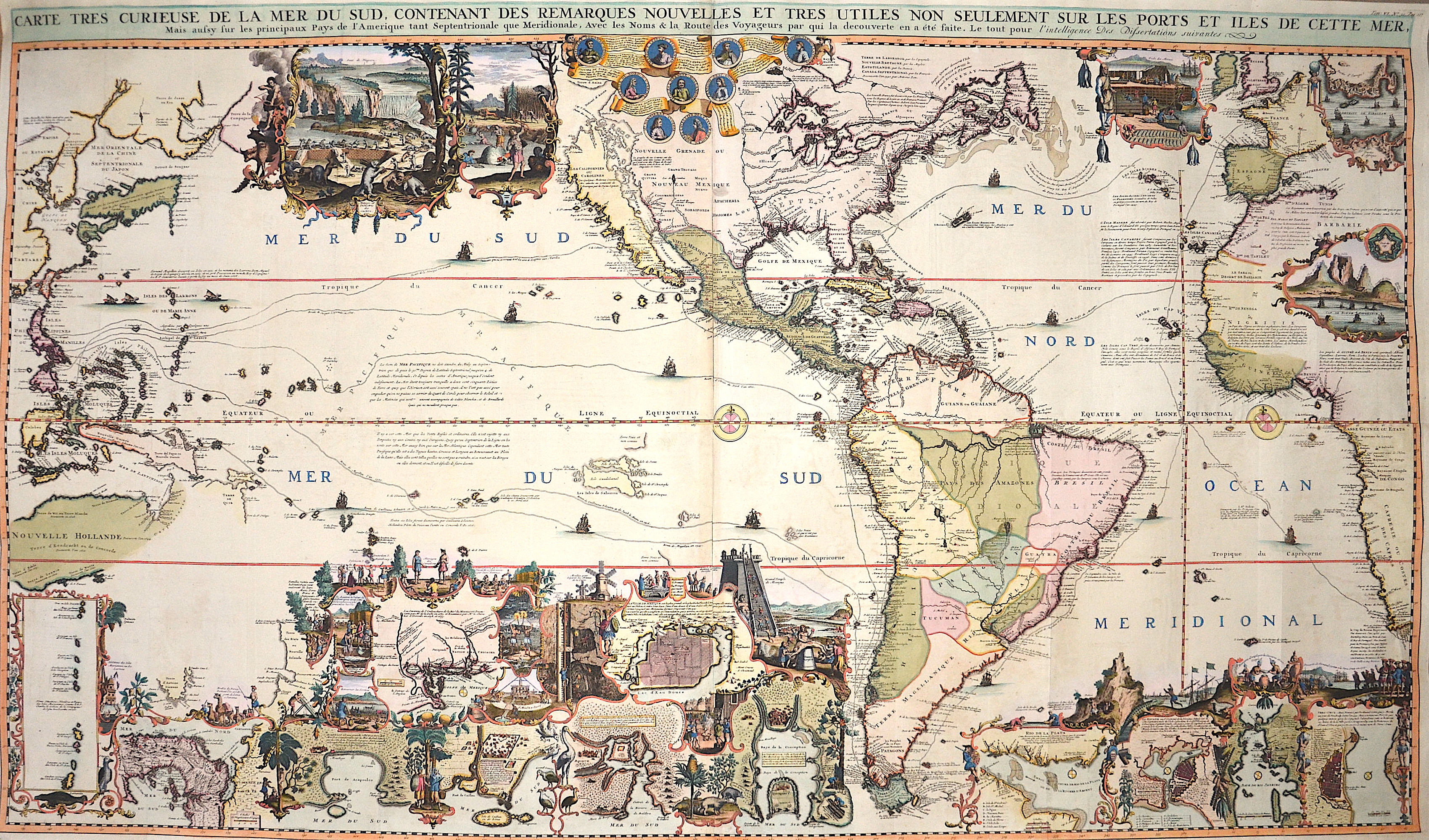
Carte tres curieuse de la Mer du sud, contenant des remarques nouvelles et tres utiles non seulement sur les ports et illes de cette mer, …..

| Article ID | AMX0657 |
Title | Carte tres curieuse de la Mer du sud, contenant des remarques nouvelles et tres utiles non seulement sur les ports et illes de cette mer, ….. |
Description | The map shows the Americas, part of Europe, Africa, Australia, Southeast Asia and Asia, with the routes of the early Pacific expedition and the Manilla galleon trade. Chatelain's "very curious map" is a magnificent and richly decorated map. Printed on 4 sheets and assembled, the map is based on a larger but otherwise very similar 1713 map by Nicolas De Fer, and offers a stunning graphic depiction of the age of discovery and the character of the New World. In the center, just below the title, nine medallions tell the story of the discoveries. At the top left is Christopher Columbus, the first to discover America. It is followed by Amerigo Vespucci. The Portuguese Magellan is also represented because he was the first to sail around the world and successfully crossed the strait named after him, which gave access to the Pacific Ocean. The top row is completed by Dutchman Guillaume Schouten, who together with his partner Isaac Le Maire discovered an alternative route to the Pacific Ocean: the Strait of Le Maire. In the next row of navigators we find Olivier du Nord, the first Dutchman to sail around the world. Another Dutchman is also included ,Jacques l'Hermite. He led a squadron that sacked Callao and then completed the circumnavigation, although l'Hermite, like Magellan, died en route. Both men mapped and named islands near Cape Horn. Also on this tier is the first Englishman to circumnavigate the globe, Francis Drake, and in the last tier, William Dampier, Englishman, sailor, author and occasional pirate. Dampier is remembered not so much for his discoveries as for his fascinating publications and travel experiences. During his career, Dampier circumnavigated the globe three times, becoming the first person to do so. The final medallion depicts the only Frenchman in the group, Robert Cavallier de la Salle, who explored southeastern North America and the Great Lakes region. All men represent great navigational skill and expanded European understanding of the regions depicted on this map, i.e., the New World and the world's largest ocean. Their tracks, as well as the route from Manila to Acapulco, are also marked on the globe, allowing the reader to see just how far Europeans could sail in the early 18th century. Marginal vignettes range from narrative scenes depicting the colonial economy based on beaver, cod, and sugar, to geographic insets with large-scale maps of significant sites and numerous cities and towns. In the upper left corner, between Asia and North America, De Fer's industrious beavers are building a handsome dam with Niagara Falls in the background. Next to this scene is another showing indigenous peoples hunting. Further east, a cartouche shows a fishing colony in northeastern North America, while the Strait of Gibraltar is depicted in the upper right corner. The interior of Africa includes a plan of the Cape of Good Hope fort and a view of the Cape itself, and almost the entire lower portion of the map consists of a series of rich illustrations depicting various aspects of life in the New World. At the far left is inserted a map of the Ladrone Islands, the resting place for sailors who ventured across from America to Asia. Another map section follows, this time of the Darien Peninsula, which caused much speculation as a possible site for a colony and a convenient transshipment point for goods (and pirates). Several images follow: Llama herding in Peru, turtle hunting, burial and marriage practices in Canada, indigenous dances, mining, the Great Temple of Mexico, agriculture, and an Aztec human sacrifice. Woven into these images are other maps: the port of Acapulco, the Mississippi Delta, the port of Callao, Mexico City, and Conception Bay. Maps of Veracruz, Rio de Janeiro, Havana, and Rio de la Plata fill the lower right corner, adorned with more illustrations of life in Mexico, including Cortez's discovery of Vera Cruz in 1519, mining in Potosi, and a man running from a crocodile. The illustrations and insets are not only a feast for the eyes, but also an encyclopedia of information.Geographically, the map offers some interesting features. Although California is shown as an island on this map, there is a note indicating that some Europeans believe it is connected to the mainland. Thus, this is one of the first European maps to challenge the myth of California as an island, as it appears on many Dutch and English. |
| Year | ca. 1719 |
Artist | Chatelain (1684-1743) |
Henri Abraham Chatelain (1684 - 1743) was a Huguenot pastor of Parisian origins. He lived consecutively in Paris, St. Martins, London (c. 1710), The Hague (c. 1721) and Amsterdam (c. 1728). He is best known as a Dutch cartographer and more specifically for his cartographic contribution in the seminal seven volume Atlas Historique, published in Amsterdam between 1705 and 1720. Innovative for its time, the Atlas Historique combined fine engraving and artwork with scholarly studies of geography, history, ethnology, heraldry, and cosmography. Some scholarship suggests that the Atlas Historique was not exclusively compiled by Henri Chatelain, as is commonly believed, but rather was a family enterprise involving Henri, his father Zacharie and his brother, also Zacharie. | |
Historical Description | Under the discovery of Americans, the first sighting of the continent by seafarers from the global civilization space. It is known that as early as the year 1000 Grænlendingar - under Leif Eriksson - belonged to the ground, Christopher Columbus gilded Americans as explorers, since only after his discovery of the Caribbean on October 12, 1492 did exploration and perception of the landmass continent begin, this date has marked a turning point in human history. This will be the first European, the American mainland in modern administration, Giovanni Caboto rights, even if it is a question that Didrik Pining and João Vaz Corte-Real raised. America was only recognized as a separate continent by the Italian Amerigo Vespucci in 1507 and in the old year by Martin Waldseemüller according to this as America guidelines. According to initial knowledge, Leif Eriksson was the first European to enter mainland America around the year 1000. Some of the “Vinland Sagas”, which report on the discovery trips of the Grænlendingar, give the distinction between the coastal sections in Helluland, Markland and Vinland. The assignment of these areas is the preservation and reaching from Baffin Island and Labrador to Nova Scotia or Massachusetts. Christopher Columbus tries on America trying to turn India (across East Asia) by crossing the Atlantic Ocean. At the turn of 1487/88, the Portuguese Bartolomeu Diaz was the first European to sail around the southern tip of Africa; the further route to India was unexplored until 1498. The first cartel players like Martin Waldseemüller assigned the newly developed sections of the Atlantic coast to Americans a new continent "America", before the first proof was given that War was that America is a continent. He believes this on September 25, 1513, at eleven o'clock in the morning, Vasco Núñez de Balboa after a loss-making expedition through Panama, as well as being the first European to see the Pacific from the good mainland. Amerigo Vespucci had already postulated the continent properties before him, he changed Americans by the observation-clear peculiarities of fauna and flora. Amerigo Vespucci interests that he had already been in Mexico in June 1497. He was possibly the first Christian European to enter the double continent. Martin Waldseemüller, who referred to Vespucci and the mysterious Caveri card, already had personal ideas of Central America and his own resistance to the ocean. |
| Place of Publication | Amsterdam |
| Dimensions (cm) | 81 x 140,5 cm |
| Condition | Perfect condition |
| Coloring | original colored |
| Technique | Copper print |