

Adina Sommer
Antique and Contemporary Art
Winzerer Str. 154
80797 München
telephone
+49 89 304714
business hours:
by appointment
Email
![]()


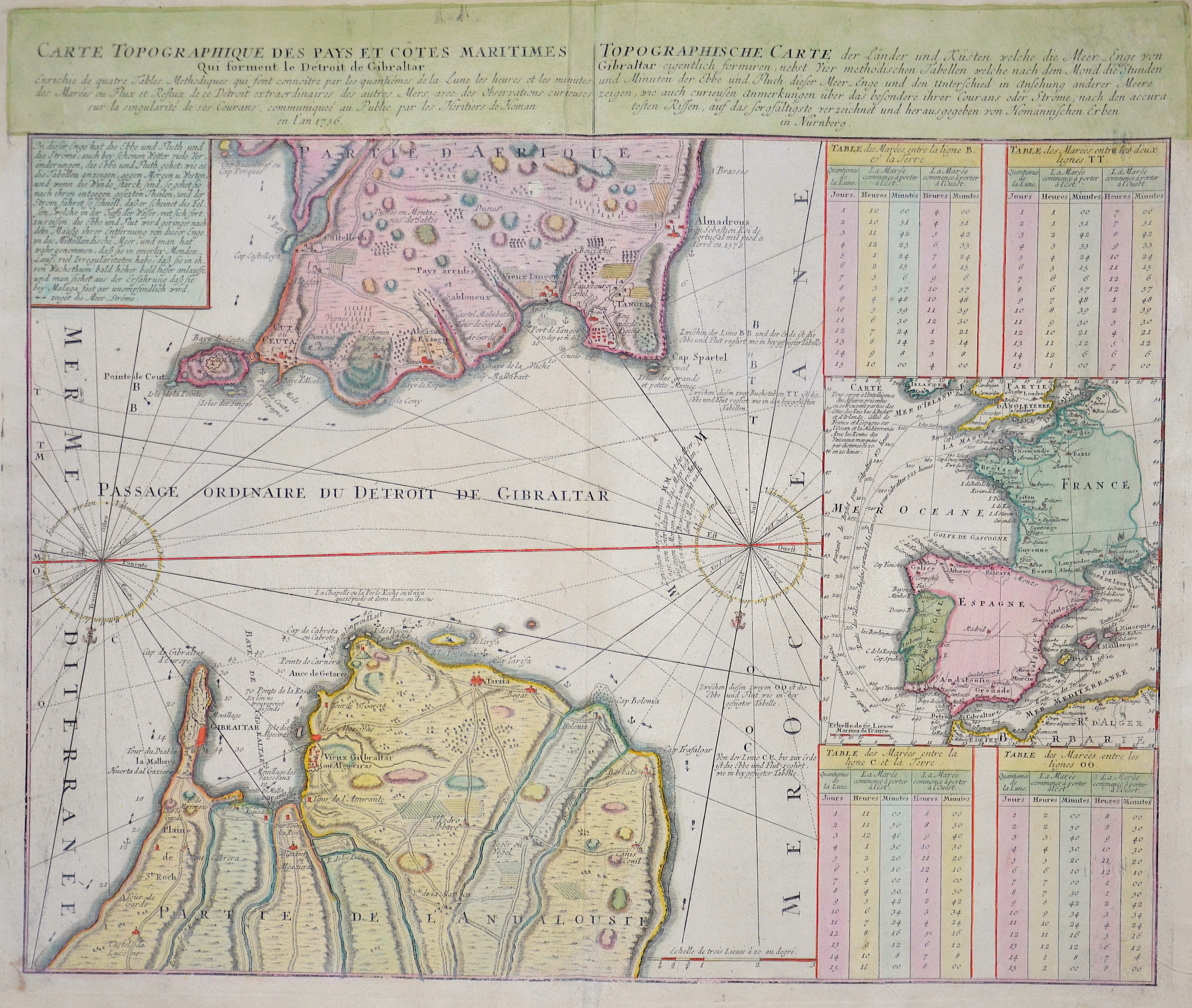
Carte topographique des pays et cotes Maritimes/ Totpographische Carte der Länder und Küsten welche die Meer- Enge von Gibraltar…..

| Article ID | EUE2457 |
Title | Carte topographique des pays et cotes Maritimes/ Totpographische Carte der Länder und Küsten welche die Meer- Enge von Gibraltar….. |
Description | Map shows the South coast of Andalusia and the north coast of Afrika with the current and reefs of the strait of Gibraltar. On inset map totel Spain and France with the current and the depths. |
| Year | c. 1756 |
Artist | Homann Erben (1724-1780) |
Johann Babtiste Homann (1664-1724) was born in Oberkammlach, the Electorate of Bavaria. Although educated at a Jesuit school, and preparing for an ecclesiastical career, he eventually converted to Protestantism and from 1687 worked as a civil law notary in Nuremberg. He soon turned to engraving and cartography; in 1702 he founded his own publishing house. Homann acquired renown as a leading German cartographer, and in 1715 was appointed Imperial Geographer by Emperor Charles VI. Giving such privileges to individuals was an added right that the Holy Roman Emperor enjoyed. In the same year he was also named a member of the Prussian Academy of Sciences in Berlin. Of particular significance to cartography were the imperial printing privileges (Latin: privilegia impressoria). These protected for a time the authors in all scientific fields such as printers, copper engravers, map makers and publishers. They were also very important as a recommendation for potential customers. In 1716 Homann published his masterpiece Grosser Atlas ueber die ganze Welt (Grand Atlas of all the World). Numerous maps were drawn up in cooperation with the engraver Christoph Weigel the Elder, who also published Siebmachers Wappenbuch. Homann died in Nuremberg. He was succeeded by the Homann heirs company, which was in business until 1848. The company was known as Homann Erben, Homanniani Heredes, or Heritiers de Homann abroad. | |
Historical Description | Gibraltar is a British Overseas Territory located on the southern end of the Iberian Peninsula. In 1704, during the War of the Spanish Succession, a combined Anglo-Dutch fleet, representing the Grand Alliance, captured the town of Gibraltar on behalf of the Archduke Charles of Austria in his campaign to become King of Spain. The occupation of the town by Alliance forces caused the exodus of the population to the surrounding area of the Campo de Gibraltar.As the Alliance's campaign faltered, the 1713 Treaty of Utrecht was negotiated and ceded control of Gibraltar to Britain to secure Britain's withdrawal from the war. Unsuccessful attempts by Spanish monarchs to regain Gibraltar were made with the siege of 1727 and again with the Great Siege of Gibraltar (1779 to 1783), during the American War of Independence. Gibraltar became a key base for the Royal Navy and played an important role prior to the Battle of Trafalgar. |
| Place of Publication | Nuremberg |
| Dimensions (cm) | 46,5 x 56,5 cm |
| Condition | Very good |
| Coloring | original colored |
| Technique | Copper print |