

Adina Sommer
Antique and Contemporary Art
Winzerer Str. 154
80797 München
telephone
+49 89 304714
business hours:
by appointment
Email
![]()


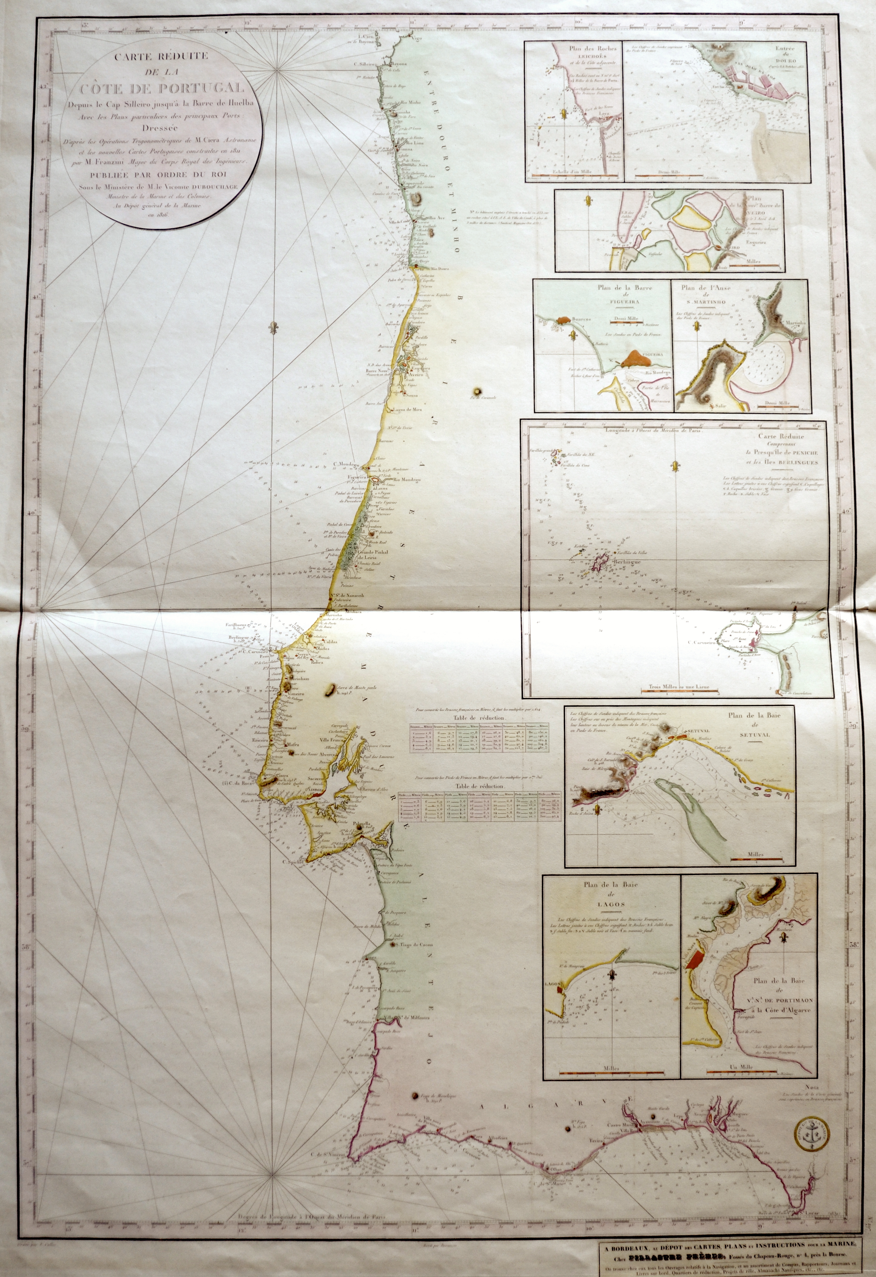
Carte Réduite de la Còte de Portugal

| Article ID | EUE4135 |
Title | Carte Réduite de la Còte de Portugal |
Description | Detailed sea chart of the coast of Portugal with 9 inset maps showing Setúbal, Leça do Balio,delta of Duero near Porto, Aveiro, Figueira da Foz, São Martinho do Porto, Berlengas Archipel ati Peniche, Lagos and Portimão. Das Jahr 1419 gilt als Jahr der Wiederentdeckung durch den portugiesischen Seefahrer João Gonçalves Zarco. Es ist jedoch bekannt, dass schon im 14. Jahrhundert Schiffe auf ihrer Rückfahrt von den Kanaren regelmäßig hier anlegten. Ab 1420 wurde Madeira auf Betreiben Heinrichs des Seefahrers von den Portugiesen besiedelt. |
| Year | ca. 1816 |
Artist | Depot de la Marine |
The Dépôt de Cartes and plans for the navy and cartography of the service were created in 1720. It is a direct analysis of the hydrography and the océanographique Actuel de la Marine. In 1720, a Navy service was ordered to collect, maps, newspapers, and memoirs about Navy . The storage of maps and plans quickly becomes a place for the tasks of cards to play their role in the storage of documents. In 1773 he became the monopoly for the task of nautical charts à France. | |
Historical Description | Portugal is the oldest state on the Iberian Peninsula and one of the oldest in Europe, its territory having been continuously settled, invaded and fought over since prehistoric times. The pre-Celtic people, Celts, Carthaginians and Romans were followed by the invasions of the Visigoths and Suebi Germanic peoples. In the 15th and 16th centuries, Portugal established the first global empire, becoming one of the world's major economic, political and military powers. During this period, today referred to as the Age of Discovery, Portuguese explorers pioneered maritime exploration, notably under royal patronage of Prince Henry the Navigator and King John II, with such notable voyages as Bartolomeu Dias' sailing beyond the Cape of Good Hope (1488), Vasco da Gama's discovery of the sea route to India (1497–98) and the European discovery of Brazil (1500). During this time Portugal monopolized the spice trade, divided the world into hemispheres of dominion with Castille, and the empire expanded with military campaigns in Asia. However, events such as the 1755 Lisbon earthquake, the country's occupation during the Napoleonic Wars, the independence of Brazil (1822), and a late industrialization compared to other European powers, erased to a great extent Portugal's prior opulence. |
| Place of Publication | Paris |
| Dimensions (cm) | 89,5 x 60 cm |
| Condition | Printed on 2 sheets joined together |
| Coloring | colored |
| Technique | Copper print |