

Adina Sommer
Antique and Contemporary Art
Winzerer Str. 154
80797 München
telephone
+49 89 304714
business hours:
by appointment
Email
![]()


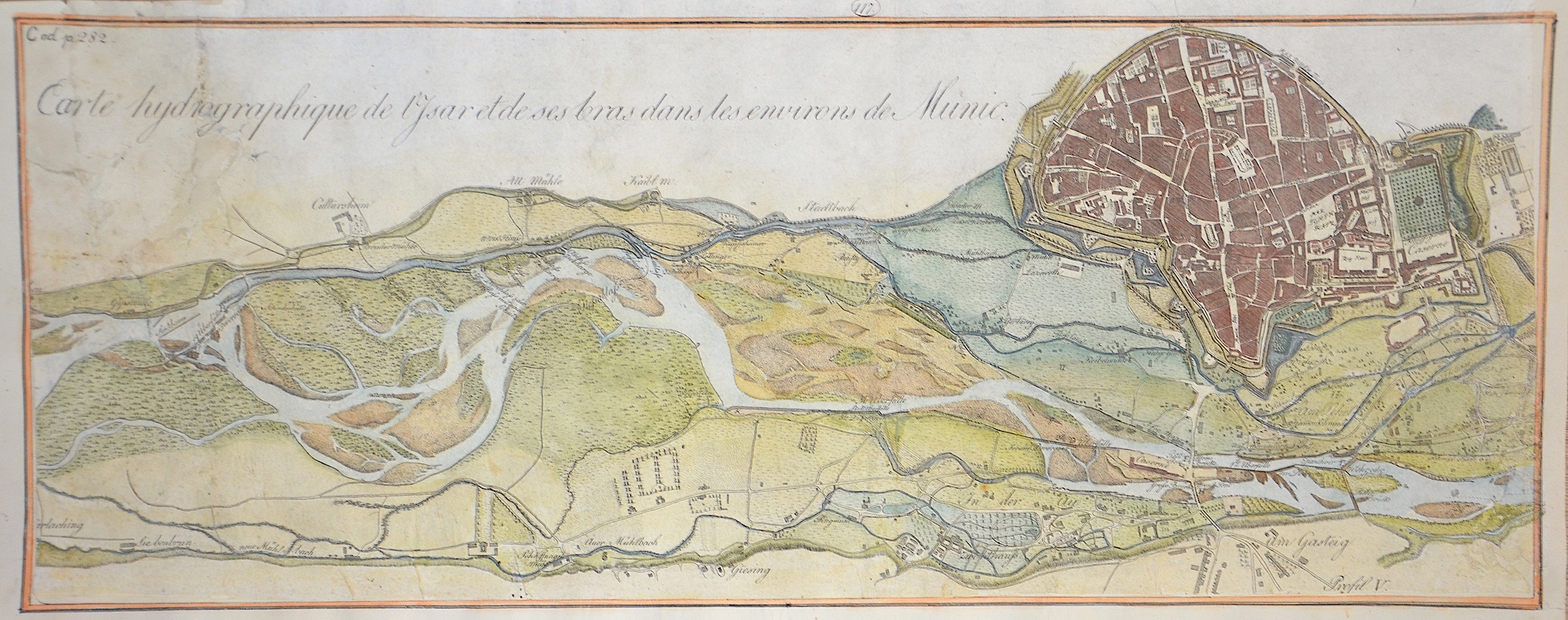
Carte hydrographique de l’Isar et de ses bras dans les environs de Munic.

| Article ID | EUD5019 |
Title | Carte hydrographique de l’Isar et de ses bras dans les environs de Munic. |
Description | Hydrographic map showing the course of the river and the tributaries of the Isar from Thalkirchen to the English Garden. Furthermore, a detailed city map of Munich. From the "Strom Atlas von Bayern" ( river atlas of Bavaria). |
| Year | ca. 1800 |
Artist | Riedl (1746-1809) |
Adrian Franz Xaver Florian Riedl, from 1790 von Riedl (1746-1809) was a German topographer and cartographer, coming from a family of cartographers who determined construction and surveying in Bavaria for over 75 years. In 1764 he fell on the scholars of the Bavarian Academy of Sciences in Munich through his cartographic implementation of the survey results of the French cartographer César François Cassini de Thury (1714–1784), which he had carried out in 1761 and 1762 in Bavaria. After the examination by the academy, Riedl was appointed electoral land geometer in 1766 and commissioned with the recording of the Bavarian road network in 1769. Over the years he followed his father in his positions as court chamber councilor (1771) and water, bridge and road construction commissioner ( 1772) according to. Together with General Building Director Joseph Aloys von Hofstetten, he developed the institutionalization and professionalization of construction and surveying. Adrian von Riedl's cartographic work of the Bavarian colonel and in various offices with road, bridge and especially hydraulic engineering could have been crowned with the Stromatlas if it had not been unfinished due to his sudden death. Nevertheless, the sheets published in several subscription deliveries were and still are the best and most accurate reproduction of Bavarian waters and could only be replaced by the Topographical Bureau 1812-1867 (see Topographical Atlas of Baiern) in the course of the official state survey. | |
Historical Description | Munich- Munchen, the name of the city is derived from the Old/Middle High German term Munichen, meaning "by the monks". It derives from the monks of the Benedictine order who ran a monastery at the place that was later to become the Old Town of Munich; hence the monk depicted on the city's coat of arms. Munich was first mentioned in 1158. From 1255 the city was seat of the Bavarian Dukes. Black and gold — the colours of the Holy Roman Empire — have been the city's official colours since the time of Ludwig the Bavarian, when it was an imperial residence. Following a final reunification of the Wittelsbachian Duchy of Bavaria, previously divided and sub-divided for more than 200 years, the town became the country's sole capital in 1506. Catholic Munich was a cultural stronghold of the Counter-Reformation and a political point of divergence during the resulting Thirty Years' War, but remained physically untouched despite an occupation by the Protestant Swedes; as the townsfolk would rather open the gates of their town than risk siege and almost inevitable destruction. Like wide parts of the Holy Roman Empire, the area recovered slowly economically. Having evolved from a duchy's capital into that of an electorate (1623), and later a sovereign kingdom (1806), Munich has been a centre of arts, culture and science since the early 19th century. |
| Place of Publication | Munich |
| Dimensions (cm) | 21,5 x 53,5 cm |
| Condition | Trimmed, missing part on the left, right and lower margin |
| Coloring | colored |
| Technique | Copper print |