

Adina Sommer
Antique and Contemporary Art
Winzerer Str. 154
80797 München
telephone
+49 89 304714
business hours:
by appointment
Email
![]()


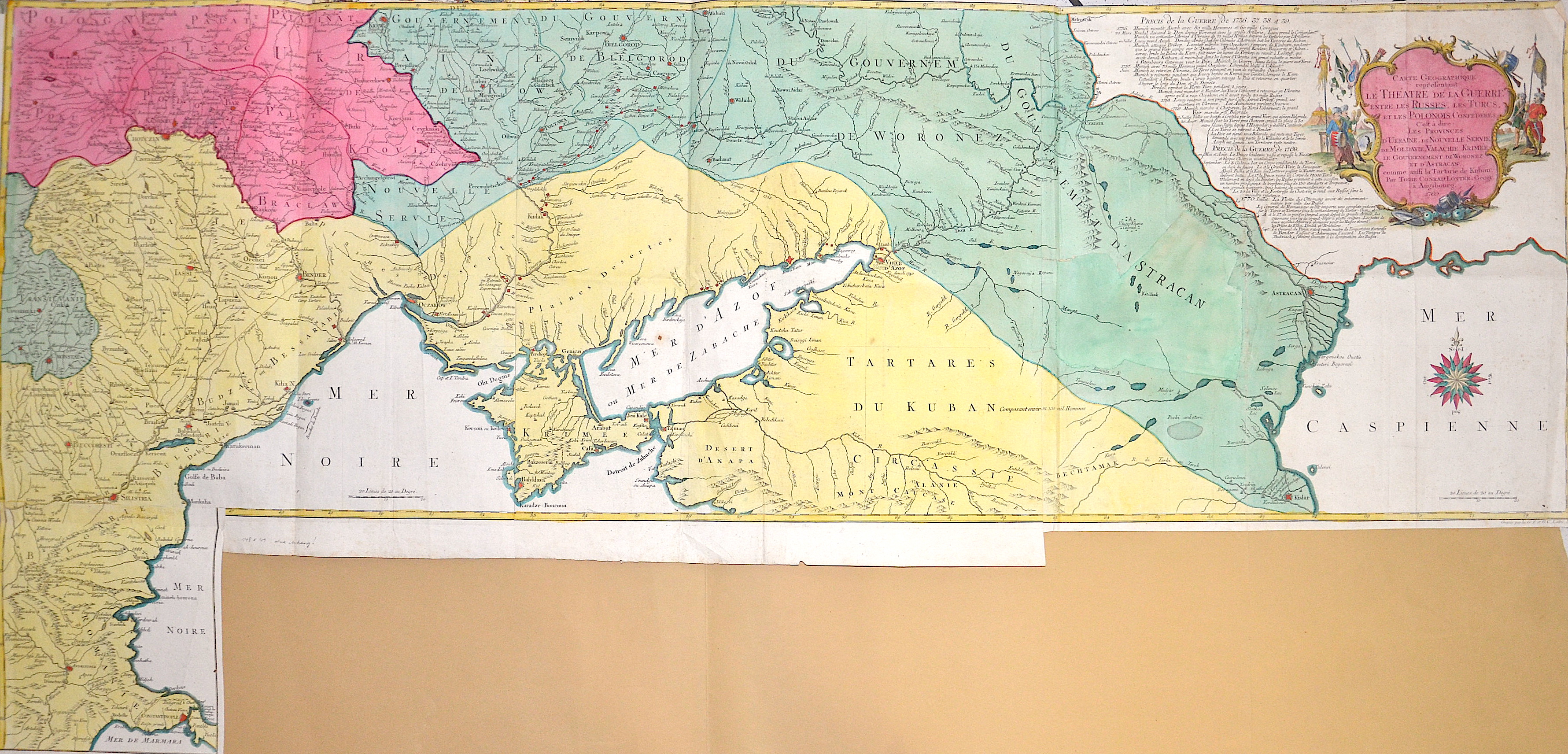
Carte Geographique representant le Theatre de la Guerre entre les Russes, les Turcs, et les Polonois Confederes,..

| Article ID | EUO4969 |
Title | Carte Geographique representant le Theatre de la Guerre entre les Russes, les Turcs, et les Polonois Confederes,.. |
Description | Interesting map showing the area of the Russo-Turkish Wars. On the right a large magnificent title cartouche and a detailed text describing the different stages and the wars of 1736 - 1739 and 1769. It was printed on 4 plates and set together. This edition has the extension in the lower left corner showing the area from Silistra via Andrinople (now Edirne) to Constantinople. |
| Year | c. 1769 |
Artist | Lotter (1717-1777) |
Tobias Conrad Lotter ( 1717- 1777) was a carthographer and publisher in Augsburg. He married the elder daughter of Matthäus Seutters and worked in the company of his father in la was map maker. He produced under the „ eye“ of M. Seutter his first „ Asia minor“ atlas between 1740 and 1744. The Asia minor altas of Lotter, Praecipua orbis terrarum imperia, regna et provincias, Germania potissimum tabelli 80 exactae delineatis sistens usui militiae ducum ac peregrinantium maxime accommodatus opera contains 63 maps, mosly Lotters work and other maps from Seutter where he put his name in the lower margin. | |
Historical Description | Neanderthal settlement in Ukraine is seen in the Molodova archaeological sites, which include a mammoth bone dwelling. The territory is also considered to be the likely location for the human domestication of the horse. In the mid-14th century, upon the death of Bolesław Jerzy II of Mazovia, king Casimir III of Poland initiated campaigns (1340–1366) to take Galicia-Volhynia. Meanwhile, the heartland of Rus', including Kiev, became the territory of the Grand Duchy of Lithuania, ruled by Gediminas and his successors, after the Battle on the Irpen' River. In 1648, Bohdan Khmelnytsky and Petro Doroshenko led the largest of the Cossack uprisings against the Commonwealth and the Polish king John II Casimir. After Khmelnytsky made an entry into Kiev in 1648, where he was hailed liberator of the people from Polish captivity, he founded the Cossack Hetmanate which existed until 1764. In 1657–1686 came "The Ruin", a devastating 30-year war amongst Russia, Poland, Turks and Cossacks for control of Ukraine. In 1709, Cossack Hetman Ivan Mazepa (1639–1709) defected to Sweden against Russia in the Great Northern War (1700–1721). Lithuanians and Poles controlled vast estates in Ukraine, and were a law unto themselves. After the Annexation of Crimea by the Russian Empire in 1783, New Russia was settled by Ukrainians and Russians. |
| Place of Publication | Augsburg |
| Dimensions (cm) | 48,5 (72) x 148,5 cm |
| Condition | Missing parts on left side perfectly restored |
| Coloring | original colored |
| Technique | Copper print |