

Adina Sommer
Antique and Contemporary Art
Winzerer Str. 154
80797 München
telephone
+49 89 304714
business hours:
by appointment
Email
![]()


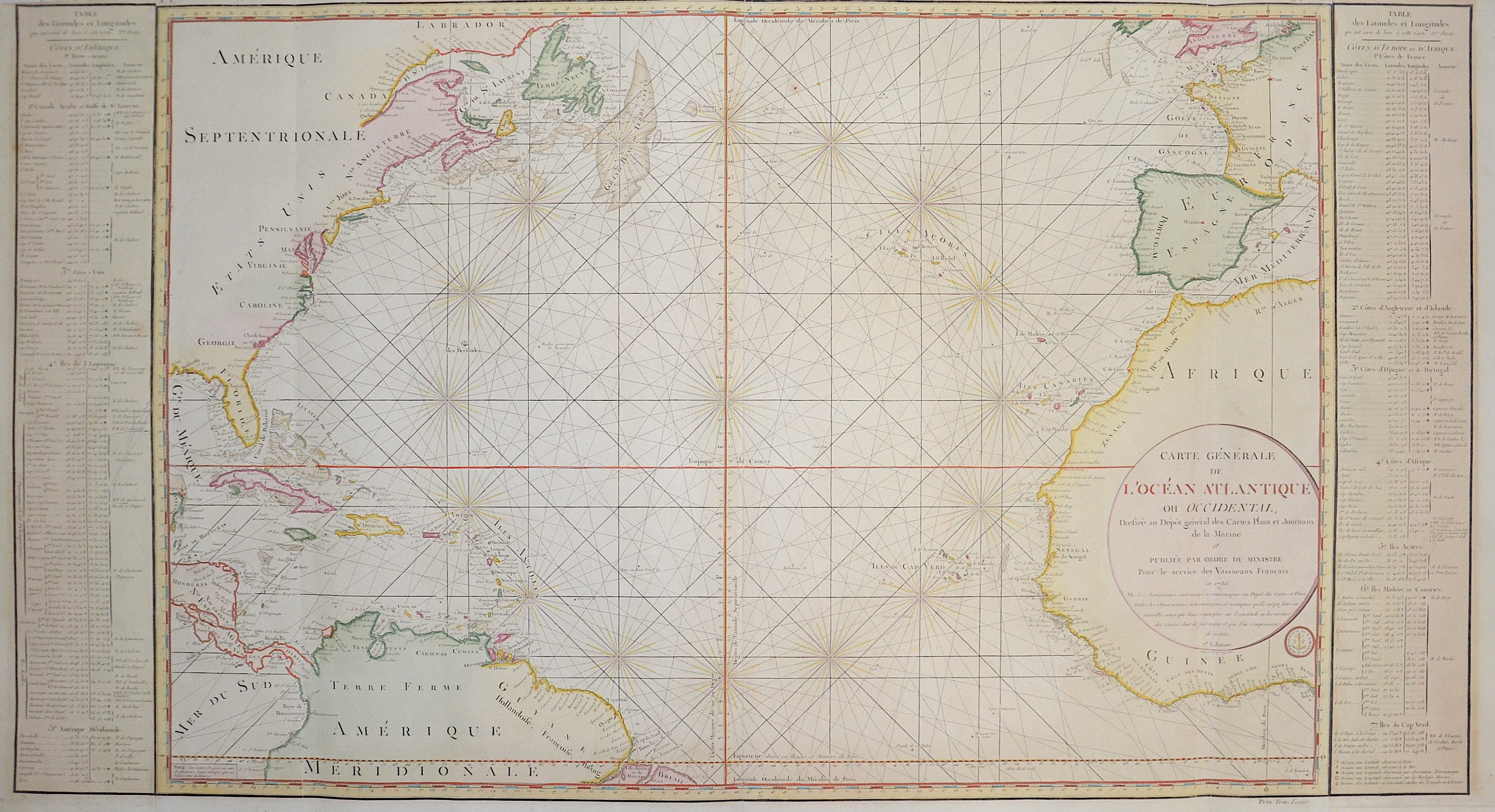
Carte Générale de L’Océan Atlantique ou Occidentall,..

| Article ID | SE0313 |
Title | Carte Générale de L’Océan Atlantique ou Occidentall,.. |
Description | Nautical chart of the northern Atlantic Ocean with the east coast of the Americas, the Caribbean, the west coast of Europe and Africa. The associated index on the left and right. |
| Year | c. 1786 |
Artist | Bellin (1703-1772) |
Jacques-Nicolas Bellin (1703 Paris -1772 Versailles) was a French cartographer, engineer-geographer, marine hydrographer. As a contributor to the Encyclopédie, he wrote more than a thousand articles on maritime topics. As a cartographer, Bellin distinguished himself primarily in the field of sea cartography. From 1721 he worked for the Dépot des Cartes et Plans de la Marine, from 1741 until his death as an engineer-hydrograph of the Navy. In 1753 his atlas Neptune français, which covered all the coasts of France, was published, and in 1756 the hydrography françoise covering all seas of the earth. In 1764 the five-volume Petit Atlas maritime was published, which Bellin prepared on the orders of the Minister of the Navy, Choiseul. In addition, he wrote a number of geographical works and with Nouvelle méthode pour apprendre la geographie (1769) a geographic textbook for teaching. His maps illustrated, among other things, Bougainville's work Voyage autour du monde, published in 1771. As a co-author of the Encyclopédie edited by Diderot and d'Alembert, Bellin wrote more than a thousand articles in the field of shipping and navy. | |
Historical Description | For a long time in human history, the Atlantic was the great body of water that separated the "Old World" from the "New World." Covering an area of about 106 million square kilometers, the Atlantic Ocean makes up roughly one-fifth of the Earth's surface. Due to its vast size, the Atlantic is commonly divided into the North Atlantic and the South Atlantic. In the 17th century, the Atlantic Ocean was a central stage for global trade, colonialism, and naval power politics among the European powers. European countries such as Spain, Portugal, England, France, and the Netherlands used the Atlantic for their colonial ventures. The Americas, West Africa, and the Caribbean were interconnected through the Atlantic—economically, politically, and militarily. The transatlantic triangular trade flourished: European goods were brought to Africa, exchanged for enslaved people, who were then shipped to the Americas. From there, raw materials such as sugar, tobacco, or cotton were transported back to Europe. Thus, the Atlantic was also a major zone of intensive slave trade. The Atlantic routes were dangerous: in addition to natural hazards, there were also pirates and conflicts between rival colonial powers. By around 1680, the Atlantic had become the backbone of the emerging global economic system—shaped by colonialism, the slave trade, and naval power. It connected continents, but also spread violence, exploitation, and power struggles. After Christopher Columbus's first crossing in 1492, regular ocean crossings did not begin until the 19th century. People in Europe wanted to leave behind the poor living conditions of the time and start a new life in the rapidly developing Americas. This led to large waves of emigration.The first transatlantic steamship set sail from Bremerhaven on July 2, 1847. |
| Place of Publication | Paris |
| Dimensions (cm) | 60,5 x 112 cm |
| Condition | Some browning |
| Coloring | original colored |
| Technique | Copper print |