

Adina Sommer
Antique and Contemporary Art
Winzerer Str. 154
80797 München
telephone
+49 89 304714
business hours:
by appointment
Email
![]()


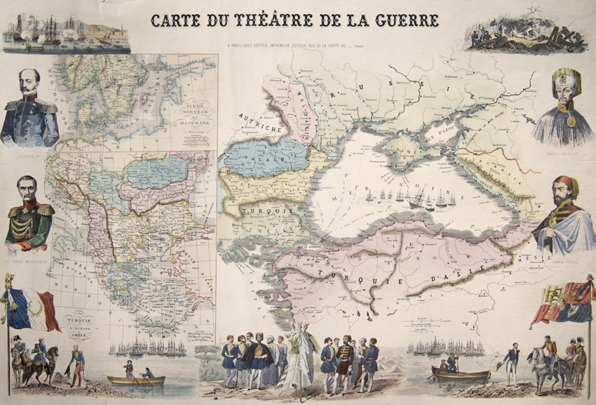
Carte Du Theatre de la Guerre

| Article ID | AST0980 |
Title | Carte Du Theatre de la Guerre |
Description | Decorative and spledourfull map of the black sea and its bordering countries. Map with the black sean and Russia, Moldavia, Wallachei, Bulgaria and Turkey with Istanbul. With portraits of important men, Abdul- Medjid- Sultan of the ottoman empire, Omer-Pacha- Ottoman General, Nicolas and Prince Menschikoff. On inset maps Greece and Sweden with Norway and Denmark. The map is sourrounded by historical views and events of the Ottoman war at the Krim, (Turkey and Russia, 1853- 1856). Issued from Dopter, Jules Emile, Paris (1843- 1879), a French Lithograph and publisher. |
| Year | ca. 1865 |
Artist | Dopter (1843-1879) |
Jules Emile Dopter (1843-1897): 1867 related to the lithographer and Doucier patents of his brother Jean Vincent Alfred. In 1879 the Dopter company was developed by the printer Morel. Jean Vincent Marie Dopter (1807-1859) founded this printing company and later also the lithographic institute Krieg Krieg. In 1834 he only had 6 gravure printing machines, in 1852 he had 17 lithography and 15 gravure printing machines and interesting 150 workers. His most important image productions came from these printing machines. In the late 1840s the printer specialized in religious images. | |
Historical Description | The area of today's Turkey has been populated since the Paleolithic. The name of the Turks comes from Central Asia. The immigrants from whom Turkey got its name were the Oghusen and came from the area around the Aral Sea. The Turkish settlement of Anatolia began with the arrival of the Seljuks in the 11th century AD. Around 1299, Osman I, Gazi (1259–1326) founded the Ottoman dynasty named after him, from which the name of the Ottoman Empire (also called the Turkish Empire) ) derives. After the conquest of Constantinople in 1453, the Ottomans ruled over large parts of the Middle East, North Africa, the Crimea, the Caucasus and the Balkans. After the expansion of the Ottoman Empire into Europe was brought to a standstill near Vienna and the Ottoman army was defeated there on Kahlenberg in 1683, the empire was pushed back further and further from its European territories to the tip west of the Marmara Sea, between Istanbul and Edirne. The national movements that emerged from the 19th century onwards led to a gradual fragmentation of the empire, the occupation of Turkish North Africa by European powers and finally the defeat in the First World War resulted in its ultimate decline. |
| Place of Publication | Paris |
| Dimensions (cm) | 55 x 84 cm |
| Condition | Some folds partly restored, right lower corner replaced |
| Coloring | colored |
| Technique | Lithography |