

Adina Sommer
Antique and Contemporary Art
Winzerer Str. 154
80797 München
telephone
+49 89 304714
business hours:
by appointment
Email
![]()


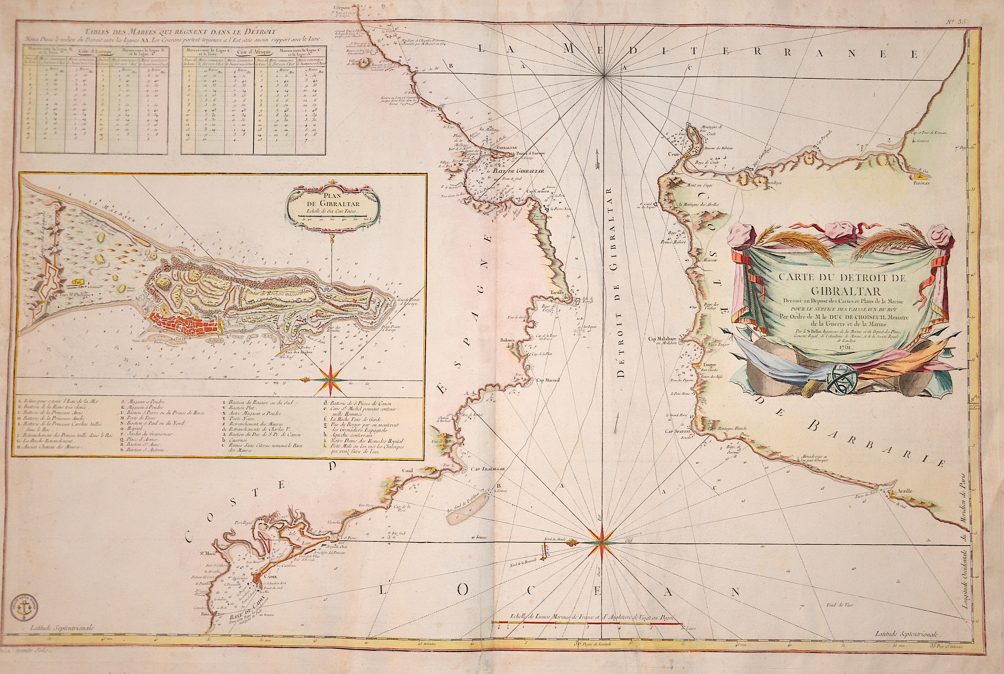
Carte du Detroit de Gibraltar../ Plan de Gibraltar

| Article ID | EUE2986 |
Title | Carte du Detroit de Gibraltar../ Plan de Gibraltar |
Description | Splendourful and detailed seachart of the strait of Gibraltar locating harbors and bays and coastal soundings. Inset map shows a city map of Gibraltar. Depiction of the sea- depht, the cartouche shows nautical instruments and banners. |
| Year | dated 1761 |
Artist | Bellin (1703-1772) |
Jacques-Nicolas Bellin (1703 Paris -1772 Versailles) was a French cartographer, engineer-geographer, marine hydrographer. As a contributor to the Encyclopédie, he wrote more than a thousand articles on maritime topics. As a cartographer, Bellin distinguished himself primarily in the field of sea cartography. From 1721 he worked for the Dépot des Cartes et Plans de la Marine, from 1741 until his death as an engineer-hydrograph of the Navy. In 1753 his atlas Neptune français, which covered all the coasts of France, was published, and in 1756 the hydrography françoise covering all seas of the earth. In 1764 the five-volume Petit Atlas maritime was published, which Bellin prepared on the orders of the Minister of the Navy, Choiseul. In addition, he wrote a number of geographical works and with Nouvelle méthode pour apprendre la geographie (1769) a geographic textbook for teaching. His maps illustrated, among other things, Bougainville's work Voyage autour du monde, published in 1771. As a co-author of the Encyclopédie edited by Diderot and d'Alembert, Bellin wrote more than a thousand articles in the field of shipping and navy. | |
Historical Description | Gibraltar is a British Overseas Territory located on the southern end of the Iberian Peninsula. In 1704, during the War of the Spanish Succession, a combined Anglo-Dutch fleet, representing the Grand Alliance, captured the town of Gibraltar on behalf of the Archduke Charles of Austria in his campaign to become King of Spain. The occupation of the town by Alliance forces caused the exodus of the population to the surrounding area of the Campo de Gibraltar.As the Alliance's campaign faltered, the 1713 Treaty of Utrecht was negotiated and ceded control of Gibraltar to Britain to secure Britain's withdrawal from the war. Unsuccessful attempts by Spanish monarchs to regain Gibraltar were made with the siege of 1727 and again with the Great Siege of Gibraltar (1779 to 1783), during the American War of Independence. Gibraltar became a key base for the Royal Navy and played an important role prior to the Battle of Trafalgar. |
| Place of Publication | London |
| Dimensions (cm) | 57 x 88 |
| Condition | Some restoration at lower centerfold |
| Coloring | original colored |
| Technique | Copper print |