

Adina Sommer
Antique and Contemporary Art
Winzerer Str. 154
80797 München
telephone
+49 89 304714
business hours:
by appointment
Email
![]()


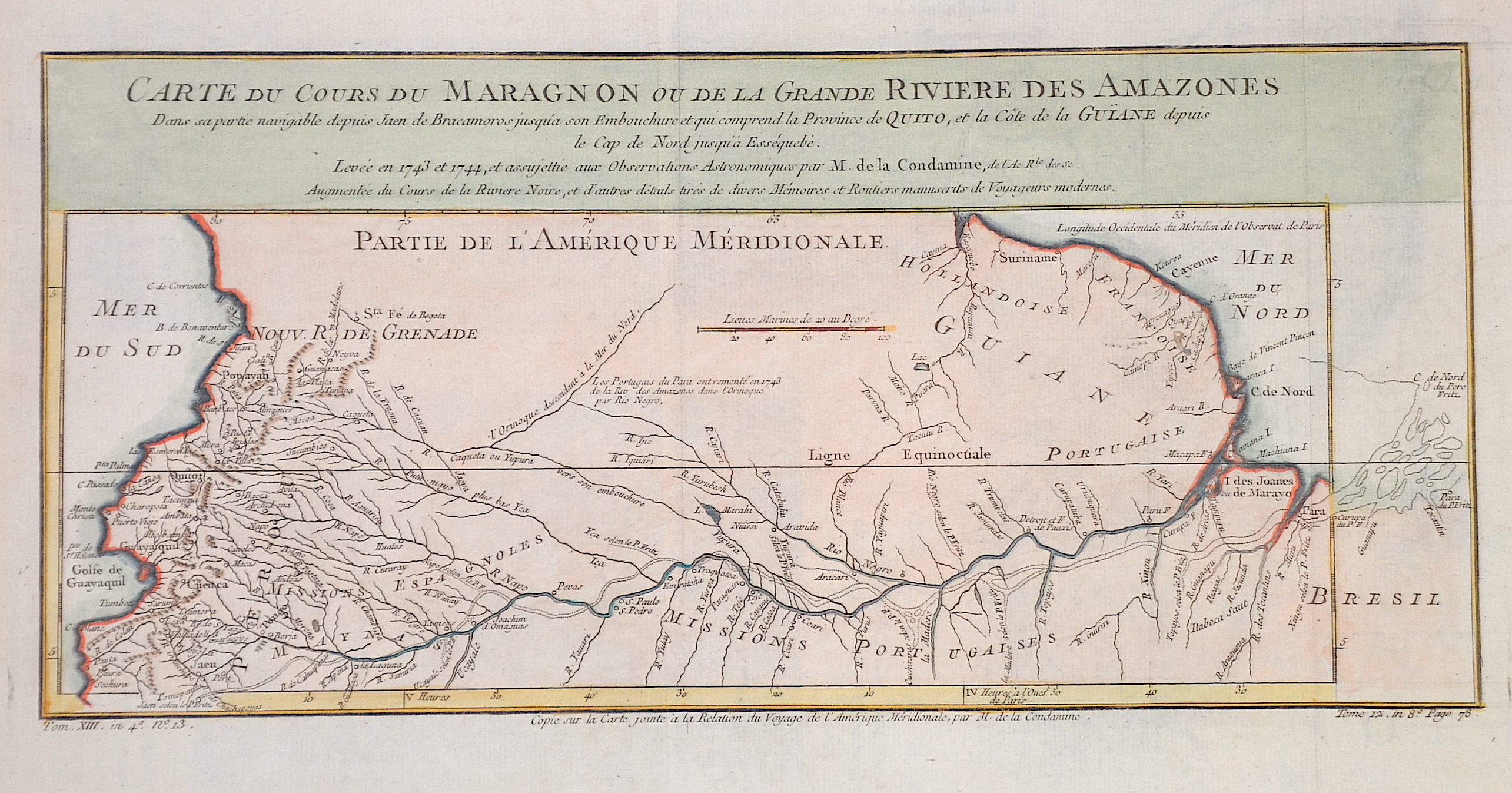
Carte du Cours du Maragnon ou de la Grande Riviere des Amazones

| Article ID | AMS1154 |
Title | Carte du Cours du Maragnon ou de la Grande Riviere des Amazones |
Description | Map of the river Amazonas. |
| Year | ca. 1758 |
Artist | Bellin (1703-1772) |
Jacques-Nicolas Bellin (1703 Paris -1772 Versailles) was a French cartographer, engineer-geographer, marine hydrographer. As a contributor to the Encyclopédie, he wrote more than a thousand articles on maritime topics. As a cartographer, Bellin distinguished himself primarily in the field of sea cartography. From 1721 he worked for the Dépot des Cartes et Plans de la Marine, from 1741 until his death as an engineer-hydrograph of the Navy. In 1753 his atlas Neptune français, which covered all the coasts of France, was published, and in 1756 the hydrography françoise covering all seas of the earth. In 1764 the five-volume Petit Atlas maritime was published, which Bellin prepared on the orders of the Minister of the Navy, Choiseul. In addition, he wrote a number of geographical works and with Nouvelle méthode pour apprendre la geographie (1769) a geographic textbook for teaching. His maps illustrated, among other things, Bougainville's work Voyage autour du monde, published in 1771. As a co-author of the Encyclopédie edited by Diderot and d'Alembert, Bellin wrote more than a thousand articles in the field of shipping and navy. | |
Historical Description | The Amazon River, usually abbreviated to The Amazon in South America is the largest river by discharge volume of water in the world, and either the longest or second longest. In 1500, Spanish conquistador Vicente Yáñez Pinzón was the first documented European to sail up the Amazon River. Pinzón called the stream Río Santa María del Mar Dulce, later shortened to Mar Dulce, literally, sweet sea, because of its fresh water pushing out into the ocean. Another Spanish explorer, Francisco de Orellana, was the first European to travel from the origins of the upstream river basins, situated in the Andes, to the mouth of the river. In this journey, Orellana baptised some of the affluents of the Amazonas like Rio Negro, Napo and Jurua. The name Amazonas is taken from the native warriors that attacked this expedition. In what is currently Brazil, Ecuador, Bolivia, Colombia, Peru, and Venezuela, a number of colonial and religious settlements were established along the banks of primary rivers and tributaries for the purpose of trade, slaving and evangelisation among the indigenous peoples of the vast rainforest, such as the Urarina. |
| Place of Publication | Paris |
| Dimensions (cm) | 18 x 38 |
| Condition | Perfect condition |
| Coloring | original colored |
| Technique | Copper print |