

Adina Sommer
Antique and Contemporary Art
Winzerer Str. 154
80797 München
telephone
+49 89 304714
business hours:
by appointment
Email
![]()


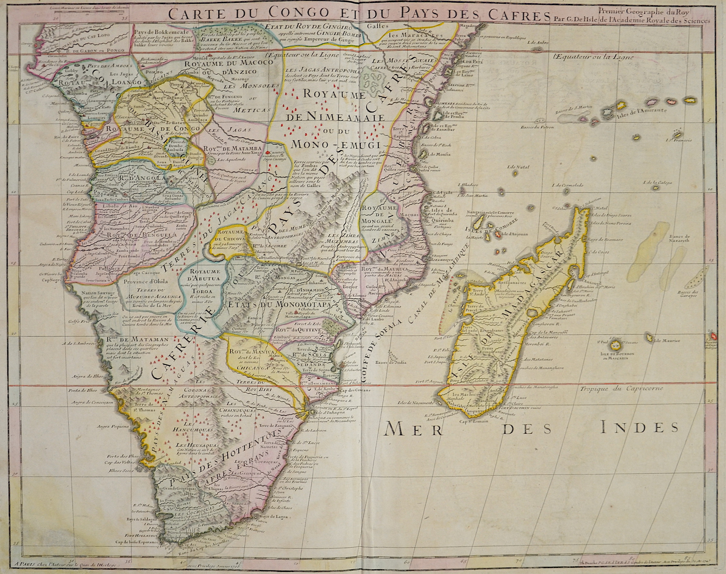
Carte du Congo et du Pays des Cafres

| Article ID | AF0513 |
Title | Carte du Congo et du Pays des Cafres |
Description | Map shows Southern Africa up to just above the equator with Madagascar, the Seychelles, Mauritius and Reunion Island in the Indian Ocean. |
| Year | ca. 1745 |
Artist | De L´Isle (1675-1725) |
Guillaume de l'Isle was a French cartographer known for his popular and accurate maps of Europe and the newly explored Americas. At 27, Delisle was admitted into the French Académie Royale des Sciences, an institution financed by the French state. After that date, he signed his maps with the title of "Géographe de l’Académie". Five years later, he moved to the Quai de l’Horloge in Paris, a true publishing hub where his business prospered. Delisle's progress culminated in 1718 when he received the title of Premier Géographe du Roi. He was appointed to teach geography to the Dauphin, King Louis XIV’s son, a task for which he received a salary. Again, his father's reputation as a man of science probably helped the younger Delisle. Historian Mary Sponberg Pedley says, "once authority was established, a geographer's name might retain enough value to support two or three generations of mapmakers". He had drawn maps not only of European countries, such as Italy, Spain, Germany, Great Britain, Poland, and regions such as the Duchy of Burgundy, but he had also contributed to the empire's claims to recently explored continents of Africa and the Americas | |
Historical Description | The term Southern Africa , refers to the southern part of the African continent. It includes Angola, Botswana, Democratic Republic of Congo, Eswatini, Comoros, Lesotho, Madagascar, Malawi, Mauritius, Mozambique, Namibia, Zambia, Seychelles, South Africa, Tanzania and Zimbabwe. According to the "Out-of-Africa theory", Africa is considered the "cradle of mankind", where homo development led to the development of the anatomically modern human Homo sapiens. One of the earliest advanced civilizations in mankind was formed in ancient Egypt. Over the millennia, various "great empires" such as the Empire of Abyssinia emerged on the continent. There were other kingdoms in West Africa, such as the Ashanti and Haussa, but they emerged much later. There were also some important cultures in East and South Africa, as in the area of today's Sudan, then called Nubia or Kush. Nubian pharaohs ruled all of Egypt for a dynasty. For example, the inhabitants of Greater Zimbabwe were important cultures in southern Africa. This stone castle was architecturally a masterpiece at that time and important for trade between the peoples of the south and east. The Swahili were known in East Africa. North Africa was connected to Europe and the Near East by the Mediterranean rather than separated. Carthage, a foundation of the Phoenicians in what is now Tunisia, was around the middle of the 1st millennium BC. The dominant power in the western Mediterranean until it was replaced by Rome in the Punic Wars. This prevailed from 30 BC. BC (conquest of Egypt) over all of North Africa. Even the ancient Egyptians (Queen Hatshepsut) made trips to Punt, probably in what is now Somalia. The kingdom of the Queen of Sheba, which probably had its center in southern Arabia, is said to have spanned parts of the Horn from Africa to the north of Ethiopia. |
| Place of Publication | Paris |
| Dimensions (cm) | 49 x 62 cm |
| Condition | Stain upper margins |
| Coloring | original colored |
| Technique | Copper print |