

Adina Sommer
Antique and Contemporary Art
Winzerer Str. 154
80797 München
telephone
+49 89 304714
business hours:
by appointment
Email
![]()


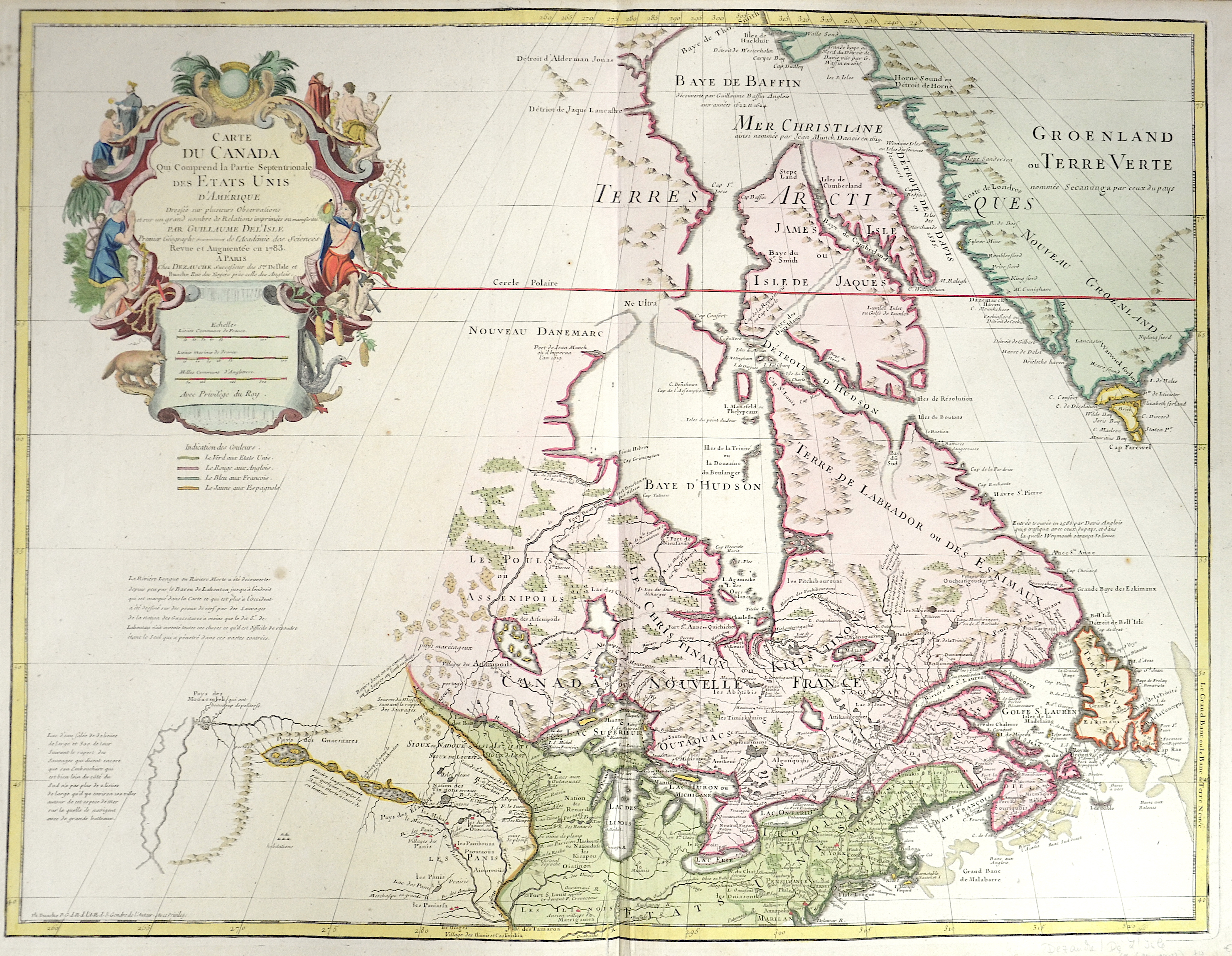
Carte du Canda qui Comprend la Partie Septentrionale des Etats Unis d´Amerique…

| Article ID | AMC0488 |
Title | Carte du Canda qui Comprend la Partie Septentrionale des Etats Unis d´Amerique… |
Description | Map shows Canada with the great lakes and partly Greenland. Splendid map, historically described as the second decauche printing of the map of De L'Isle and the first state in which the United States is named and the name United States (Etats-Unis) appears earliest on a printed map. It is worth noting that there are two different states of this 1783 "Etats Unis" map. The second has the crown at the top of the cartouche and the royal fleur-de-lis below it, as well as the words "du Roi" removed from the title, suggesting a change to the copper plate by Dezauche after the French Revolution and most likely during the First French Republic (1792-1795), inspired in part by the American Revolution. Curiously, the notation "avec privilege du Roy" at the bottom of the cartouche remains unchanged. Equally noteworthy, the map contains one of the earliest references to the Rocky Mountains, the "Riviere Longue," and other features in the west, based on the reports of Louis Armand de Lom d'Arce, Baron de Lahontan. Lahontan traveled extensively in Wisconsin, Minnesota, and the upper Mississippi Valley. Louis-Armand de Lom d'Arce (1666 - 1716), also known as Baron de Lahontan, was a French officer and traveler in the French colonies of North America. During his time in New France, he visited every nook and cranny, probably visited hitherto little explored areas around the Mississippi River, twice participated in the successful defense of English attacks. On the other hand, he left no major mark on the New World. Except for his last stay at Placentia, he was hardly mentioned in official correspondence. But with his works published in his later years, based on his diary and notes, he brought North America to Europe and became one of the most widely read authors in the first half of the 18th century. |
| Year | ca. 1792 |
Artist | L´Isle, de /Covens & Mortier (1675-1726) |
Guillaume De L’Isle (1675–1726) was a renowned French cartographer famous for his accurate maps of Europe, the Americas, and Africa. He joined the French Académie Royale des Sciences, signing his maps as “Géographe de l’Académie,” and later became Premier Géographe du Roi in 1718, teaching geography to the Dauphin. De L’Isle mostly worked from his office, relying on a strong network of traveler reports and scientific updates, ensuring his maps were precise and honest. He openly noted uncertain information, such as a disputed river in Louisiana. In 1700, he won a legal case against Jean-Baptiste Nolin for plagiarism. Unlike the Sanson workshop, which often published outdated maps, De L’Isle focused on up-to-date, scientifically grounded cartography. | |
Historical Description | Various indigenous peoples have inhabited what is now Canada for thousands of years before European colonization. Beginning in the 16th century, British and French expeditions explored and later settled along the Atlantic coast. As a consequence of various armed conflicts, France ceded nearly all of its colonies in North America in 1763. In 1867, with the union of three British North American colonies through Confederation, Canada was formed as a federal dominion of four provinces. In 1583, Sir Humphrey Gilbert, by the royal prerogative of Queen Elizabeth I, founded St. John's, Newfoundland, as the first North American English colony. French explorer Samuel de Champlain arrived in 1603 and established the first permanent European settlements at Port Royal (in 1605) and Quebec City (in 1608). Among the colonists of New France, Canadiensextensively settled the Saint Lawrence River valley and Acadians settled the present-day Maritimes, while fur traders and Catholic missionaries explored the Great Lakes, Hudson Bay, and the Mississippi watershed to Louisiana. The Beaver Wars broke out in the mid-17th century over control of the North American fur trade. The Royal Proclamation of 1763 established First Nation treaty rights, created the Province of Quebec out of New France, and annexed Cape Breton Island to Nova Scotia. After the successful American War of Independence, The 1783 Treaty of Paris recognized the independence of the newly formed United States and set the terms of peace, ceding British North American territories south of the Great Lakes to the new country. the Constitutional Act of 1791 divided the province of Canada into French-speaking Lower Canada (later Quebec) and English-speaking Upper Canada (later Ontario), granting each its own elected legislative assembly. |
| Place of Publication | Paris |
| Dimensions (cm) | 50 x 64,5 cm |
| Condition | Some restoration at lower centerfold |
| Coloring | original colored |
| Technique | Copper print |