

Adina Sommer
Antique and Contemporary Art
Winzerer Str. 154
80797 München
telephone
+49 89 304714
business hours:
by appointment
Email
![]()


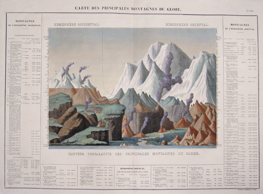
Carte des Principales Montagnes du Globe.

| Article ID | T0126 |
Title | Carte des Principales Montagnes du Globe. |
Description | Decorative an informative chart of the world's mountains. Divided into the Western Hemisphere mountains, on the left and the mountains of the Eastern Hemisphere, on the right . Also includes the relative elevations of important cities, monuments, etc. Unlike most comparative charts issued in the mid 19th century, this chart includes a reference table as part of the map itself. Lists Dalhgari, in Nepal, as the world's tallest mountain, but also features smaller mountains that today serve as sky resorts such as Mt. Mansfield and Killington in Vermont, Mt. Monandnock and Mt. Washington in New Hampshire and Saddleback in Massachusetts. This was originally published in the 1825 French Edition of Carey , Lea's 1822. - A Complete Historical...American Atlas, entitled Atlas Géographique. Statistique, Historique et Chronologique des Deux-Amériques et des îles adjacentes-.This map comes from Bouchon, J. A. C. and Carez, J., -Atlas geographique, statistique, historique et chronologique des deux Ameriques et des iles adjacentes; traduit de l'atlas execute en Amerique d'apres Lesage, avec de nombreuses corrections et augmentations, par Jean Alexandre Buchon., 1825.- |
| Year | ca. 1825 |
Artist | Carez (1815-1850) |
J. Carez (c. 1815 - 1850) was a book, atlas and map publisher actived in the early 19th century. Little is known of Carez's life. He is best known for his publication of the French edition of H. C. Carey and I. Lea's important Complete Historical, Chronological, And Geographical American Atlas. | |
| Place of Publication | Paris |
| Dimensions (cm) | 46 x 64,5 |
| Condition | Perfect condition |
| Coloring | colored |
| Technique | Copper print |