

Adina Sommer
Antique and Contemporary Art
Winzerer Str. 154
80797 München
telephone
+49 89 304714
business hours:
by appointment
Email
![]()


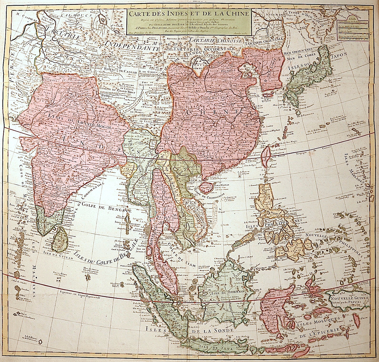
Carte des Indes et de la Chine

| Article ID | ASS307 |
Title | Carte des Indes et de la Chine |
Description | Map shows Southeast Asia with India and China |
| Year | dated 1781 |
Artist | Dezauche/de l´Isle, (1780-1838) |
Jean-Claude Dezauche (1780-1838) was the successor to Guillaume De L'Isle and Philipe Buache. Guillaume De L´Isle (1675- 1726) Paris, was a French cartographer known for his popular and accurate maps of Europe and the newly explored Americas and Africa. De L´Isle was admitted into the French Académie Royale des Sciences, an institution financed by the French state. After that date, he signed his maps with the title of “Géographe de l’Académie”. Five years later, he moved to the Quai de l’Horloge in Paris, a true publishing hub where his business prospered. De L´Isle’s ascension through the ranks culminated in 1718 when he received the title of Premier Géographe du Roi. His new office consisted in teaching geography to the Dauphin, King Louis XIV’s son, a task for which he received a salary. De L´Isle’s reputation as a man of science probably helped .This supports the claim of the historian Mary Sponberg Pedley, who says “once authority was established, a geographer’s name might retain enough value to support two or three generations of mapmakers”. In De L´Isle’s case, it could be said that his accomplishments surpassed his father’s. Up to that point, he had drawn maps not only of European countries, such as Italy, Spain, Germany, Great Britain, Poland, and regions such as the Duchy of Burgundy, but he had also contributed to the empire’s claims to recently explored continents of Africa and the Americas. Like many cartographers of these days, De L´Isle did not travel with the explorers and elaborated the maps mostly in his office. The quality of his maps depended on a solid network that would provide him first-hand information. Given the family’s reputation and his own, De L´Isle had access to fairly recent accounts of travellers who were coming back from the New World, which gave him an advantage over his competitors. Being a member of the Académie, he was also aware of recent discoveries, especially in astronomy and measurement. When he could not confirm the accuracy of his source, he would indicate it clearly on his maps. For instance, his Carte de la Louisiane shows a river that the baron of Lahontan claimed he discovered, but no one else could validate it, so De L`lsle warned the viewer that its actual existence was in doubt. De L´Isle 's search for exactitude and intellectual honesty entangled him in a legal dispute in 1700 with Jean-Baptiste Nolin, a fellow cartographer. Noticing Nolin had used details that were considered original from his Map of the World, De L´isle dragged Nolin in court to prove his plagiarism. In the end, Delisle managed to convince the jury of scientists that Nolin only knew the old methods of cartography and therefore that he had stolen the information from his manuscript. Nolin's maps were confiscated and he was forced to pay the court costs.The scientificity of the work produced by the De L´Isle family contrasted with the workshop of Sanson. While Sanson knowingly published outdated facts and mistakes, De L´Isle strived to present up-to-date knowledge. | |
Historical Description | In the first centuries after the turn of the times, Indian traders spread their culture over large parts of Southeast Asia. The Kingdom of Funan (200-550) in the Mekong Delta developed into the first center of Hinduism and Buddhism in Southeast Asia. It was replaced by the Khmer Kingdom and the Srivijaya Empire in Sumatra. 750 Borobodur was built on Java, a terraced temple complex of enormous size. The Khmer kings created an equally impressive work of art with the construction of their Angkor Wat temple complex. From the 9th century, the Tai migrated from the north to their present-day settlement areas and met the high-ranking Mon, whose culture they shaped. In 1044 the first Burmese Empire was founded with Bagan as the capital. In Southeast Asia, extensive trade had developed from the 6th to the 16th century, numerous shipwrecks testify to this development, such as that of the Lena Shoal junk. The ship types of the junk and the balangay were used for this trade. Two main routes of trade China on the one hand and Java, Sumatra and the Malay Peninsula on the other hand could be determined. One route leads along the mainland and the second route along Borneo, Palawan to the island of Luzon. In the 15th century, Arab, Persian and Indian traders converted the Malays to Islam. The Muslim Malacca took the place of the Hindu kingdom Majapahit on Java. With the exception of Siam, all Southeast Asian countries were colonized from the 16th century. The background to colonization was the region's wealth of raw materials and spices, which were of particular value at the time. After the trade had been dominated by Arab traders for a long time, the European powers now fought over supremacy in the region. The Spaniards became active in the region at the same time and colonized with the aim of conquering China and converting to Christianity the Philippines, which they named after the Spanish King Philip II. The British came to Southeast Asia as the third major colonial power and also tried to establish themselves in the region. After initially holding an insignificant base in Indonesia, after negotiating with the local sultans, they reached control of the island of Penang and Singapore, which was then a small Malay fishing village. Together with the port city of Malacca, these areas formed the so-called Straits Settlements, the most important bases for the British in Southeast Asia. |
| Place of Publication | Paris |
| Dimensions (cm) | 62,5 x 65,5 |
| Condition | Very good |
| Coloring | colored |
| Technique | Copper print |