

Adina Sommer
Antique and Contemporary Art
Winzerer Str. 154
80797 München
telephone
+49 89 304714
business hours:
by appointment
Email
![]()


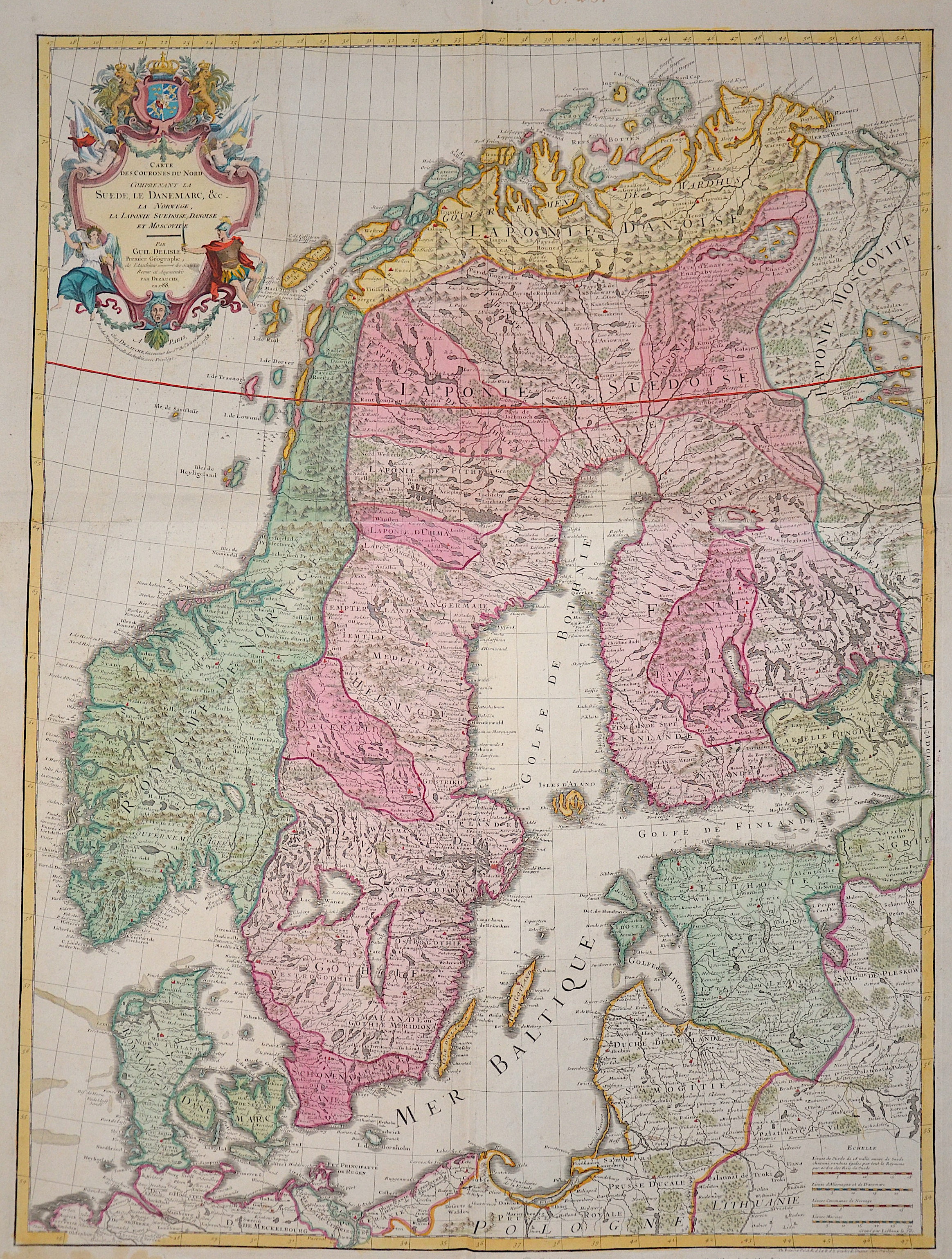
Carte des Courones du Nord comprenant la Suede, Le Danmarc, C. La Norwege, La Ponie Sueduise, Danuise et Moscovite

| Article ID | EUS611 |
Title | Carte des Courones du Nord comprenant la Suede, Le Danmarc, C. La Norwege, La Ponie Sueduise, Danuise et Moscovite |
Description | Map shows the whole of Scandinavia with Norway, Sweden, Denmark, Finland, Livonia (today Latvia and Estonia) and a magnificent title cartouche. |
| Year | dated 1788 |
Artist | Dezauche/de l´Isle, (1780-1838) |
Jean-Claude Dezauche (1780-1838) was the successor to Guillaume De L'Isle and Philipe Buache. Guillaume De L´Isle (1675- 1726) Paris, was a French cartographer known for his popular and accurate maps of Europe and the newly explored Americas and Africa. De L´Isle was admitted into the French Académie Royale des Sciences, an institution financed by the French state. After that date, he signed his maps with the title of “Géographe de l’Académie”. Five years later, he moved to the Quai de l’Horloge in Paris, a true publishing hub where his business prospered. De L´Isle’s ascension through the ranks culminated in 1718 when he received the title of Premier Géographe du Roi. His new office consisted in teaching geography to the Dauphin, King Louis XIV’s son, a task for which he received a salary. De L´Isle’s reputation as a man of science probably helped .This supports the claim of the historian Mary Sponberg Pedley, who says “once authority was established, a geographer’s name might retain enough value to support two or three generations of mapmakers”. In De L´Isle’s case, it could be said that his accomplishments surpassed his father’s. Up to that point, he had drawn maps not only of European countries, such as Italy, Spain, Germany, Great Britain, Poland, and regions such as the Duchy of Burgundy, but he had also contributed to the empire’s claims to recently explored continents of Africa and the Americas. Like many cartographers of these days, De L´Isle did not travel with the explorers and elaborated the maps mostly in his office. The quality of his maps depended on a solid network that would provide him first-hand information. Given the family’s reputation and his own, De L´Isle had access to fairly recent accounts of travellers who were coming back from the New World, which gave him an advantage over his competitors. Being a member of the Académie, he was also aware of recent discoveries, especially in astronomy and measurement. When he could not confirm the accuracy of his source, he would indicate it clearly on his maps. For instance, his Carte de la Louisiane shows a river that the baron of Lahontan claimed he discovered, but no one else could validate it, so De L`lsle warned the viewer that its actual existence was in doubt. De L´Isle 's search for exactitude and intellectual honesty entangled him in a legal dispute in 1700 with Jean-Baptiste Nolin, a fellow cartographer. Noticing Nolin had used details that were considered original from his Map of the World, De L´isle dragged Nolin in court to prove his plagiarism. In the end, Delisle managed to convince the jury of scientists that Nolin only knew the old methods of cartography and therefore that he had stolen the information from his manuscript. Nolin's maps were confiscated and he was forced to pay the court costs.The scientificity of the work produced by the De L´Isle family contrasted with the workshop of Sanson. While Sanson knowingly published outdated facts and mistakes, De L´Isle strived to present up-to-date knowledge. | |
Historical Description | Scandinavia characterized by common ethnocultural North Germanic heritage and mutually intelligible North Germanic languages The term Scandinavia in local usage covers the three kingdoms of Denmark, Norway, and Sweden, but in English usage, it also sometimes refers to the Scandinavian Peninsula or to the broader region which includes Finland and Iceland This broader region is usually known locally as the Nordic countries. The remote Norwegian islands of Svalbard and Jan Mayen are usually not seen as a part of Scandinavia, nor is Greenland, a constituent country within the Kingdom of Denmark. The Faroe Islands may be included. For more than 500 years there was a common ground in the field of foreign policy, from the attack by the Danish king Chlochilaicus on Gaul (517) to the unfortunate move by Harald Hardrades against England in 1066, the Vikings carried out their raids and raids on all European coastal areas, but also deep into Russia stretch. For a long time, another commonality was the rejection of Christianity in times when it had been common in Western Europe for centuries. In addition, the great importance of the Jarle, who were initially only leaders of raids, but as such became very rich and powerful, is characteristic of this period. For this reason, fiefdom in Scandinavia developed much more slowly than in core Europe, and serfdom did not become fully established. In addition to these general similarities, there were also times when several of the Scandinavian countries were united under one rule, such as Denmark, Norway and (more relaxed) Sweden as well as England under Knut the Great from 1028 to 1035, as well as England. Denmark and Norway were soon under the common rule of Magnus the Good from 1042 to 1046. But the main time of the common political development lies in the Kalmar Union, which the countries of Denmark, Norway and Sweden were linked from 1397 to 1523. During this period, Norway lost significant political independence, so that after Sweden left the Kalmar Union with the Danish-Norwegian personal union, there was practically Danish dominance until 1814, which was replaced in 1814 by the Swedish-Norwegian union, which continued until 1905. |
| Place of Publication | Paris |
| Dimensions (cm) | 82 x 62 cm |
| Condition | Printed on 2 sheets joined together |
| Coloring | colored |
| Technique | Copper print |