

Adina Sommer
Antique and Contemporary Art
Winzerer Str. 154
80797 München
telephone
+49 89 304714
business hours:
by appointment
Email
![]()


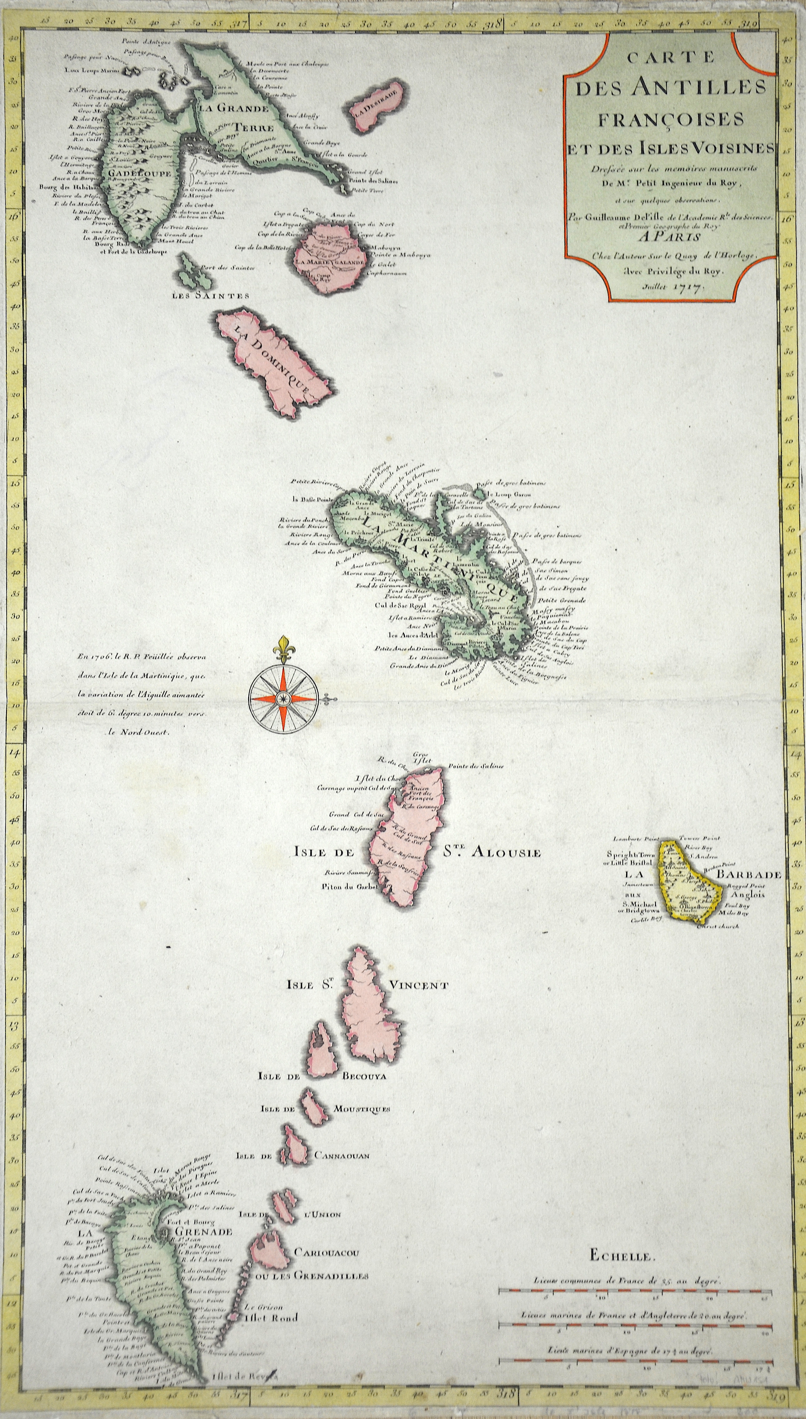
Carte des Antilles Francoises et des Isles Voisines…

| Article ID | AMW151 |
Title | Carte des Antilles Francoises et des Isles Voisines… |
Description | Map of the Lower Antilles, from Guadeloupe to Grenada. |
| Year | dated 1717 |
Artist | L´Isle, de /Covens & Mortier (1675-1726) |
Guillaume De L’Isle (1675–1726) was a renowned French cartographer famous for his accurate maps of Europe, the Americas, and Africa. He joined the French Académie Royale des Sciences, signing his maps as “Géographe de l’Académie,” and later became Premier Géographe du Roi in 1718, teaching geography to the Dauphin. De L’Isle mostly worked from his office, relying on a strong network of traveler reports and scientific updates, ensuring his maps were precise and honest. He openly noted uncertain information, such as a disputed river in Louisiana. In 1700, he won a legal case against Jean-Baptiste Nolin for plagiarism. Unlike the Sanson workshop, which often published outdated maps, De L’Isle focused on up-to-date, scientifically grounded cartography. | |
Historical Description | Saint-Martin. They are part of the Lesser Antilles. The first inhabitants of the Caribbean, the Arawaks, came from South America and the oldest archaeological evidence of human life dates from 3500 to 3000 B.C. These excellent fighters and skillful sailors populated the Caribbean at the time when Cristoph Columbus dropped anchor off Guadeloupe in 1493 and off Martinique in 1502. The examples of primitive art at the “Roches Gravés” (rock engravings) sites date back to this pre-Columbian era. The American-Indian Museum of Early History also impressively documents this era. Reconstructions of plantations on Martinique or the archaeological site of a slave house on Guadeloupe remind us that slavery was introduced in the Antilles in 1685 with the “Code Noir”. The economy was based almost entirely on specialized agriculture on a large scale: sugar cane, coffee and cocoa, which later gave way to banana cultivation. It was not until 1635 that the French succeeded in colonizing Guadeloupe, for example. In 1664, the island was transferred to the French West India Company. After its dissolution in 1674, the French crown took over the administration of the colony, with a governor at the head. At the end of the 18th century, numerous uprisings by slaves, free people of color, white planters and merchants shook France's Caribbean colonies. In the shadow of the great slave revolt of Saint-Domingue, the French colonies in the Lesser Antilles, the îles du vent - Martinique, Guadeloupe and Ste.-Lucie - were also affected by the revolutionary upheavals. In the course of the French Revolution of 1789, slavery was abolished in the French colonies and thus also in Guadeloupe in February 1794. Great Britain took advantage of the new political situation and occupied the islands in April 1794. Plantation owners feared the implementation of the declared abolition of slavery and supported the British occupation, but the French expelled the British in June 1794. Napoleon Bonaparte reintroduced slavery in the French colonies in 1802. During the Napoleonic Wars, Great Britain re-conquered Guadeloupe in February 1810. In the Peace of Paris, Sweden returned the island to France in 1814 in exchange for 24 million francs. |
| Place of Publication | Paris |
| Dimensions (cm) | 65 x 38 |
| Condition | Very good |
| Coloring | colored |
| Technique | Copper print |