

Adina Sommer
Antique and Contemporary Art
Winzerer Str. 154
80797 München
telephone
+49 89 304714
business hours:
by appointment
Email
![]()


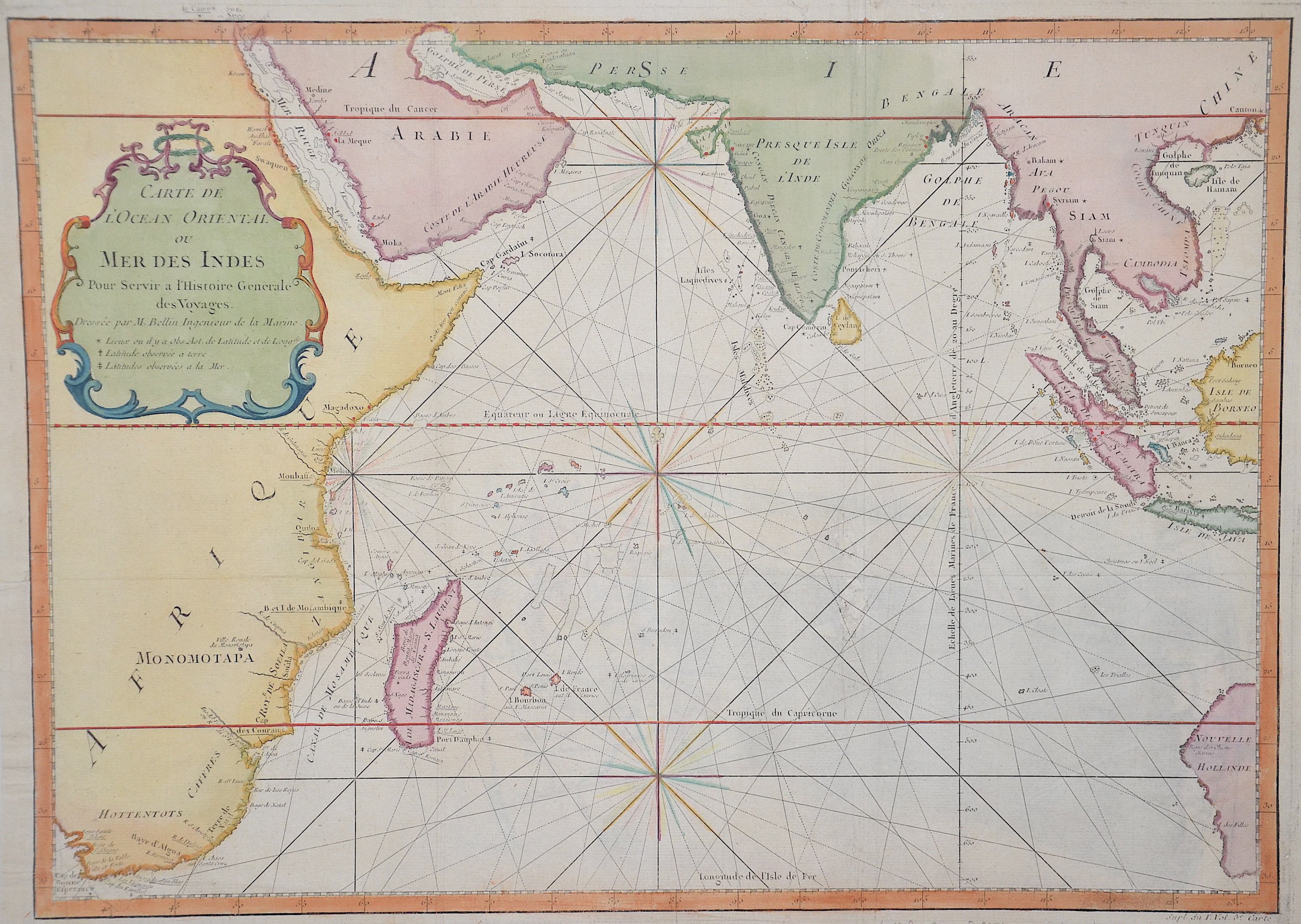
Carte de l´ocean oriental ou mer des Indes

| Article ID | SE0251 |
Title | Carte de l´ocean oriental ou mer des Indes |
Description | Map shows the Indian Ocean with its countries. |
| Year | ca. 1758 |
Artist | Bellin (1703-1772) |
Jacques-Nicolas Bellin (1703 Paris -1772 Versailles) was a French cartographer, engineer-geographer, marine hydrographer. As a contributor to the Encyclopédie, he wrote more than a thousand articles on maritime topics. As a cartographer, Bellin distinguished himself primarily in the field of sea cartography. From 1721 he worked for the Dépot des Cartes et Plans de la Marine, from 1741 until his death as an engineer-hydrograph of the Navy. In 1753 his atlas Neptune français, which covered all the coasts of France, was published, and in 1756 the hydrography françoise covering all seas of the earth. In 1764 the five-volume Petit Atlas maritime was published, which Bellin prepared on the orders of the Minister of the Navy, Choiseul. In addition, he wrote a number of geographical works and with Nouvelle méthode pour apprendre la geographie (1769) a geographic textbook for teaching. His maps illustrated, among other things, Bougainville's work Voyage autour du monde, published in 1771. As a co-author of the Encyclopédie edited by Diderot and d'Alembert, Bellin wrote more than a thousand articles in the field of shipping and navy. | |
Historical Description | The sea route to India was opened up by Portuguese explorers from the beginning of the 15th to the beginning of the 16th century and subsequently sailed by the India Armadas. It led from Europe around Africa to the Indian subcontinent and from there on to the spice islands of hind India, the Moluccas. Therefore, it was also called the Spice Route. The search for the sea route was initiated by the Portuguese prince Henry the Navigator and continued and financed by the Portuguese crown for several decades. It resulted in both the discovery of America in 1492 and the first circumnavigation of the globe, ushering in the Age of Discovery and European Expansion. The route to India and back was first sailed in 1498 by an expedition led by Vasco da Gama. It joined the previous trade routes that led, on the one hand, by sea from the Indian Ocean through the Red Sea and the Mediterranean, and, on the other hand, by the caravan routes of the Silk Road through Asia. These two routes were largely controlled by Islamic rulers. The development of the spice route by sea opened up the possibility for European merchants to trade directly with India and China. The high profits from this provided a major impetus for European colonial expansion. Instead of sailing east around Africa and the Cape of Good Hope, Christopher Columbus headed west on behalf of the Spanish crown to reach Asia. This led to the modern discovery of the Americas in 1492. Since the eastern route remained blocked to the Spaniards after the Treaty of Tordesillas concluded in 1493, they continued to search for a western route, i.e. a passage from the Atlantic to the Pacific Ocean. This was achieved in 1520 by an expedition led by Ferdinand Magellan, which ended with the first circumnavigation of the world. It was not until the construction of the Panama Canal in 1914 that the time-consuming voyage around the southern tip of the Americas became superfluous and opened up a direct western route from Europe to East Asia. |
| Place of Publication | Paris |
| Dimensions (cm) | 34 x 47,4 |
| Condition | Left, lower margin perfectly restored, fold restored |
| Coloring | original colored |
| Technique | Copper print |