

Adina Sommer
Antique and Contemporary Art
Winzerer Str. 154
80797 München
telephone
+49 89 304714
business hours:
by appointment
Email
![]()


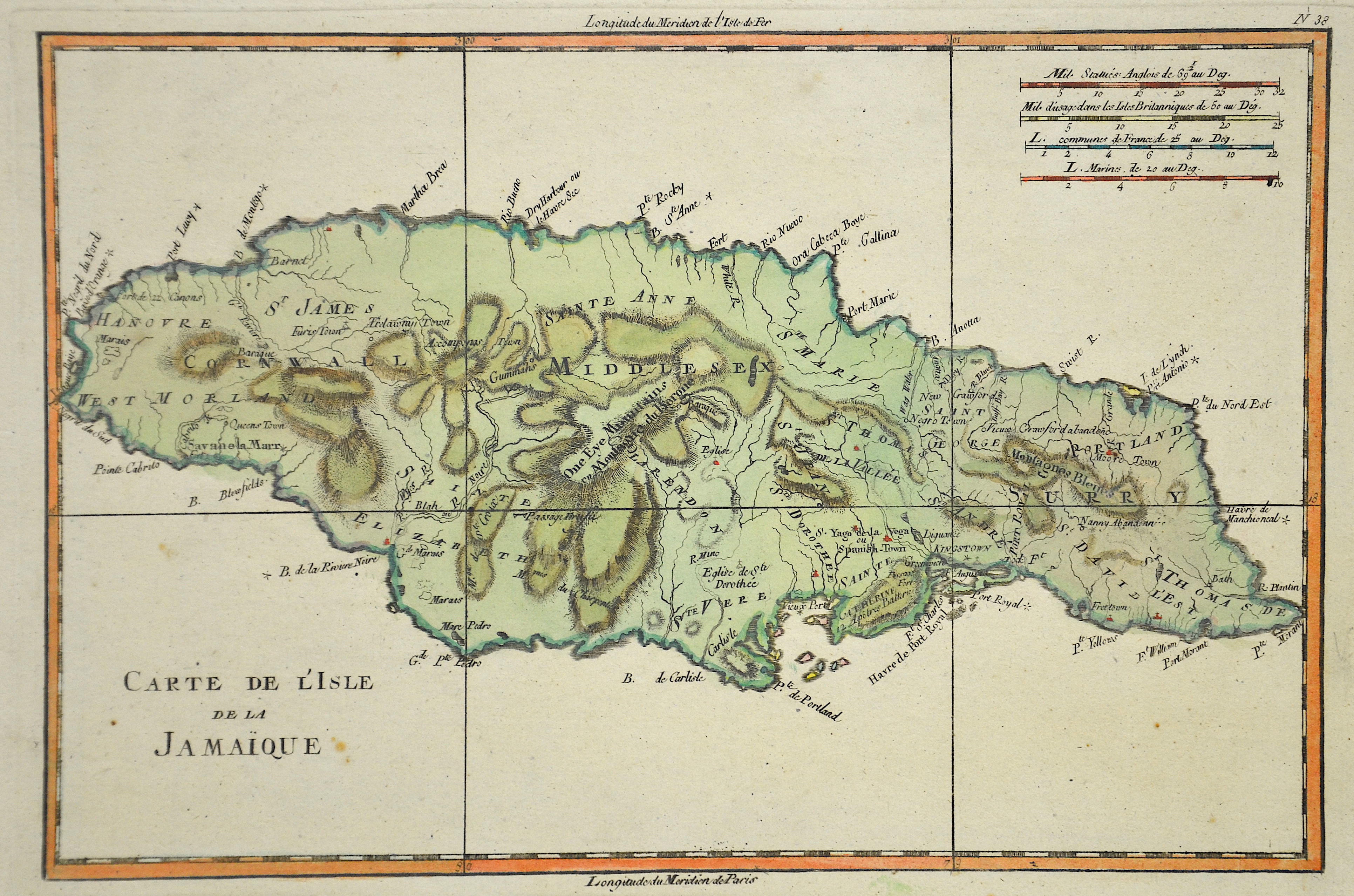
Carte de l´isle de la Jamaique

| Article ID | AMW0482 |
Title | Carte de l´isle de la Jamaique |
Description | Map shows the island of Jamaica |
| Year | ca. 1720 |
Artist | Fer, de (1646-1720) |
Nicolas de Fer ( 1646 - 1720 in Paris) was a French cartographer and geographer. He also was an engraver and publisher. De Fer was the youngest of three sons of Antoine de Fer, who was also a cartographer. When he was 12, he became the apprentice of Parisian engraver Louis Spirinx, and made his first map, of the Canal du Midi, at the age of 23. After the death of his father in June 1673, de Fer was so successful at improving the firm that, in 1690, he became the official geographer to Louis, Dauphin of France. With support from the Spanish and French Royal Families, de Fer also became official geographer for Philip V and Louis XIV, the kings of Spain and France, respectively. Because of this, his maps became Bourbon propaganda, endorsing French King Louis XIV. His business flourished, producing town plans, atlases, wall maps, and more than 600 sheet maps.He made maps of places in Europe and North America, including New Spain, places fortified by Vauban, the Low Countries, and the War of the Spanish Succession. In 1698, de Fer published a map of North America, which included a depiction of beavers building dams near Niagara Falls. Seventeen years later, Herman Moll published an identical map as his own, known as the -Beaver map-. De Fer became the official geographer for His Catholic Majesty in 1720.Two of his sons-in-law, Guillaume Danet and Jaques-François Bénard, continued the company after de Fer's death on 25 October of that year until around 1760. | |
Historical Description | In the 7th century BC the first Taíno (a people belonging to the Arawak) from South America reached the island. They lived in tribal communities and practiced agriculture and fishing. They built their houses out of reeds and straw. Small groups of the Caribbean came to Jamaica in the course of the 15th century. In contrast to the practice on many other islands, they did not expel the Taíno, but lived with them. When Christopher Columbus landed on Jamaica as the first European in 1494 during his second trip, about 100,000 people lived there. After a long dispute between Diego Columbus, the son of Christopher Columbus, and the Spanish crown over the possession of some Caribbean islands, he finally became viceroy of all the islands discovered by his father. He was given the right to keep a share of the gold found there and to levy taxes. In 1509 he had Jamaica taken over by Juan Ponce de León and called it Santiago. This name never became natural. The Spaniards also used the original Indian names Chaymakas or Xaymaca, which they twisted in Jamaica. Due to the enormous size and the difficult geographical conditions, Spain could never really protect its possessions in America - especially in the Caribbean. In the decades after the defeat of the Spanish Armada in 1588, but especially since the final decline of Spanish supremacy in the second half of the 17th century, the English, French and Dutch entered the Spanish sphere of power more and more. On 1655, English troops under Robert Venables and Admiral William Penn sen landed. in the place of today's Kingston. They had been sent by Oliver Cromwell to conquer bases in the Caribbean as part of the Western design. The administration in Spanish Town surrendered the next day, some of the remaining Spaniards fled to Cuba without a fight. In the hope of an uprising, they had previously freed their slaves and equipped them with weapons. There was no fighting at first, as the former slaves retreated to the inaccessible interior where they lived under the name of the Maroons. Despite the surrender, the last Spanish governor, Cristobal Arnaldo de Ysassi, gathered guerrilla troops on the north coast and inland. He received support from Cuba twice, but had to give up after two defeats against the English army in 1657 and 1658. In 1664, an elected assembly was established to perform local administrative functions. Jamaica formally became the property of Great Britain in 1670 through the Madrid Treaty. |
| Place of Publication | Paris |
| Dimensions (cm) | 20 x 31 |
| Condition | Very good |
| Coloring | original colored |
| Technique | Copper print |