

Adina Sommer
Antique and Contemporary Art
Winzerer Str. 154
80797 München
telephone
+49 89 304714
business hours:
by appointment
Email
![]()


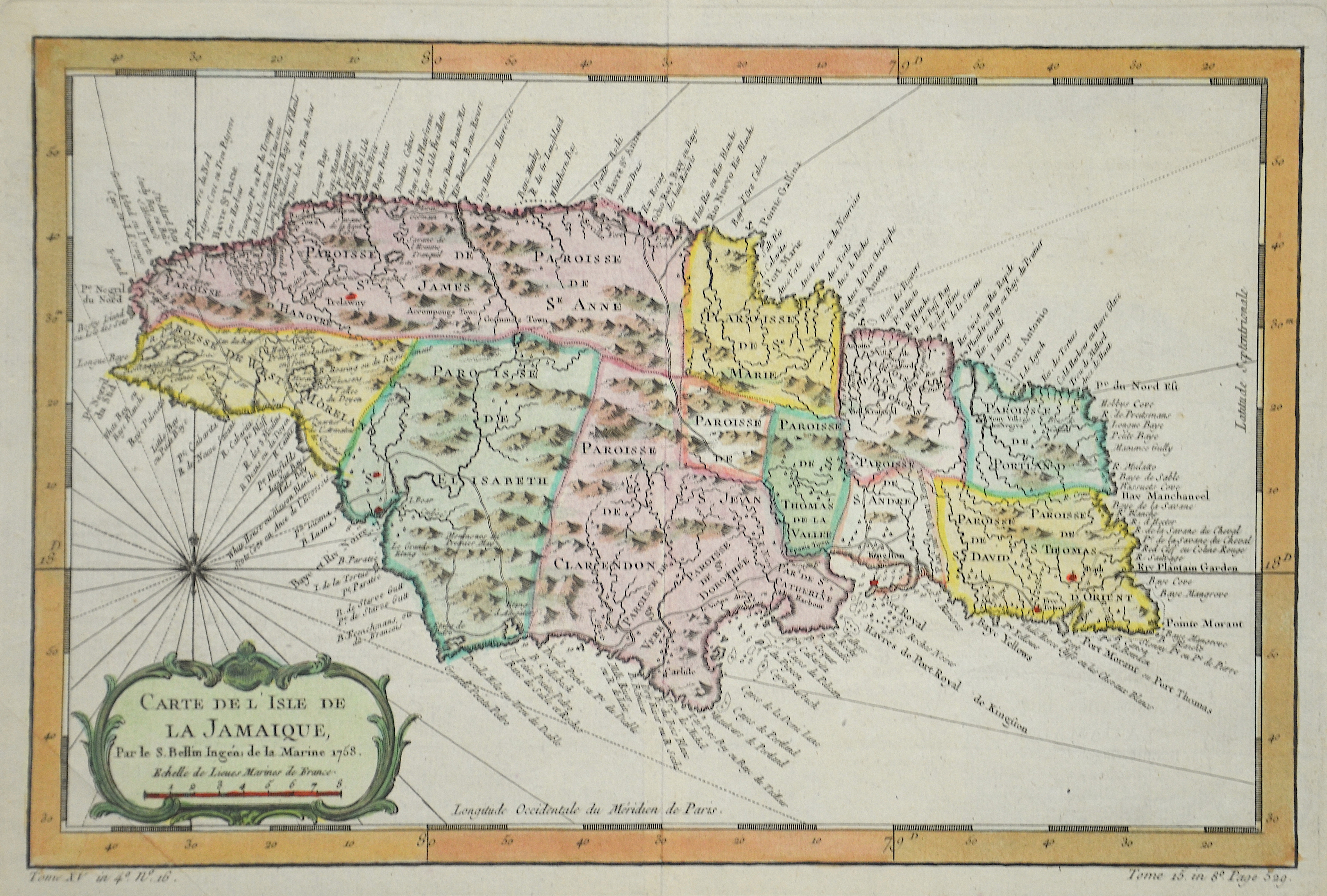
Carta dell´isola giammaica

| Article ID | AMW0530 |
Title | Carta dell´isola giammaica |
Description | Map shows Jamaica |
| Year | ca. 1763 |
Artist | Bellin (1703-1772) |
Jacques-Nicolas Bellin (1703 Paris -1772 Versailles) was a French cartographer, engineer-geographer, marine hydrographer. As a contributor to the Encyclopédie, he wrote more than a thousand articles on maritime topics. As a cartographer, Bellin distinguished himself primarily in the field of sea cartography. From 1721 he worked for the Dépot des Cartes et Plans de la Marine, from 1741 until his death as an engineer-hydrograph of the Navy. In 1753 his atlas Neptune français, which covered all the coasts of France, was published, and in 1756 the hydrography françoise covering all seas of the earth. In 1764 the five-volume Petit Atlas maritime was published, which Bellin prepared on the orders of the Minister of the Navy, Choiseul. In addition, he wrote a number of geographical works and with Nouvelle méthode pour apprendre la geographie (1769) a geographic textbook for teaching. His maps illustrated, among other things, Bougainville's work Voyage autour du monde, published in 1771. As a co-author of the Encyclopédie edited by Diderot and d'Alembert, Bellin wrote more than a thousand articles in the field of shipping and navy. | |
Historical Description | In the 7th century BC the first Taíno (a people belonging to the Arawak) from South America reached the island. They lived in tribal communities and practiced agriculture and fishing. They built their houses out of reeds and straw. Small groups of the Caribbean came to Jamaica in the course of the 15th century. In contrast to the practice on many other islands, they did not expel the Taíno, but lived with them. When Christopher Columbus landed on Jamaica as the first European in 1494 during his second trip, about 100,000 people lived there. After a long dispute between Diego Columbus, the son of Christopher Columbus, and the Spanish crown over the possession of some Caribbean islands, he finally became viceroy of all the islands discovered by his father. He was given the right to keep a share of the gold found there and to levy taxes. In 1509 he had Jamaica taken over by Juan Ponce de León and called it Santiago. This name never became natural. The Spaniards also used the original Indian names Chaymakas or Xaymaca, which they twisted in Jamaica. Due to the enormous size and the difficult geographical conditions, Spain could never really protect its possessions in America - especially in the Caribbean. In the decades after the defeat of the Spanish Armada in 1588, but especially since the final decline of Spanish supremacy in the second half of the 17th century, the English, French and Dutch entered the Spanish sphere of power more and more. On 1655, English troops under Robert Venables and Admiral William Penn sen landed. in the place of today's Kingston. They had been sent by Oliver Cromwell to conquer bases in the Caribbean as part of the Western design. The administration in Spanish Town surrendered the next day, some of the remaining Spaniards fled to Cuba without a fight. In the hope of an uprising, they had previously freed their slaves and equipped them with weapons. There was no fighting at first, as the former slaves retreated to the inaccessible interior where they lived under the name of the Maroons. Despite the surrender, the last Spanish governor, Cristobal Arnaldo de Ysassi, gathered guerrilla troops on the north coast and inland. He received support from Cuba twice, but had to give up after two defeats against the English army in 1657 and 1658. In 1664, an elected assembly was established to perform local administrative functions. Jamaica formally became the property of Great Britain in 1670 through the Madrid Treaty. |
| Place of Publication | Paris |
| Dimensions (cm) | 20,50 x 31,50 |
| Condition | Left margin replaced |
| Coloring | original colored |
| Technique | Copper print |