

Adina Sommer
Antique and Contemporary Art
Winzerer Str. 154
80797 München
telephone
+49 89 304714
business hours:
by appointment
Email
![]()


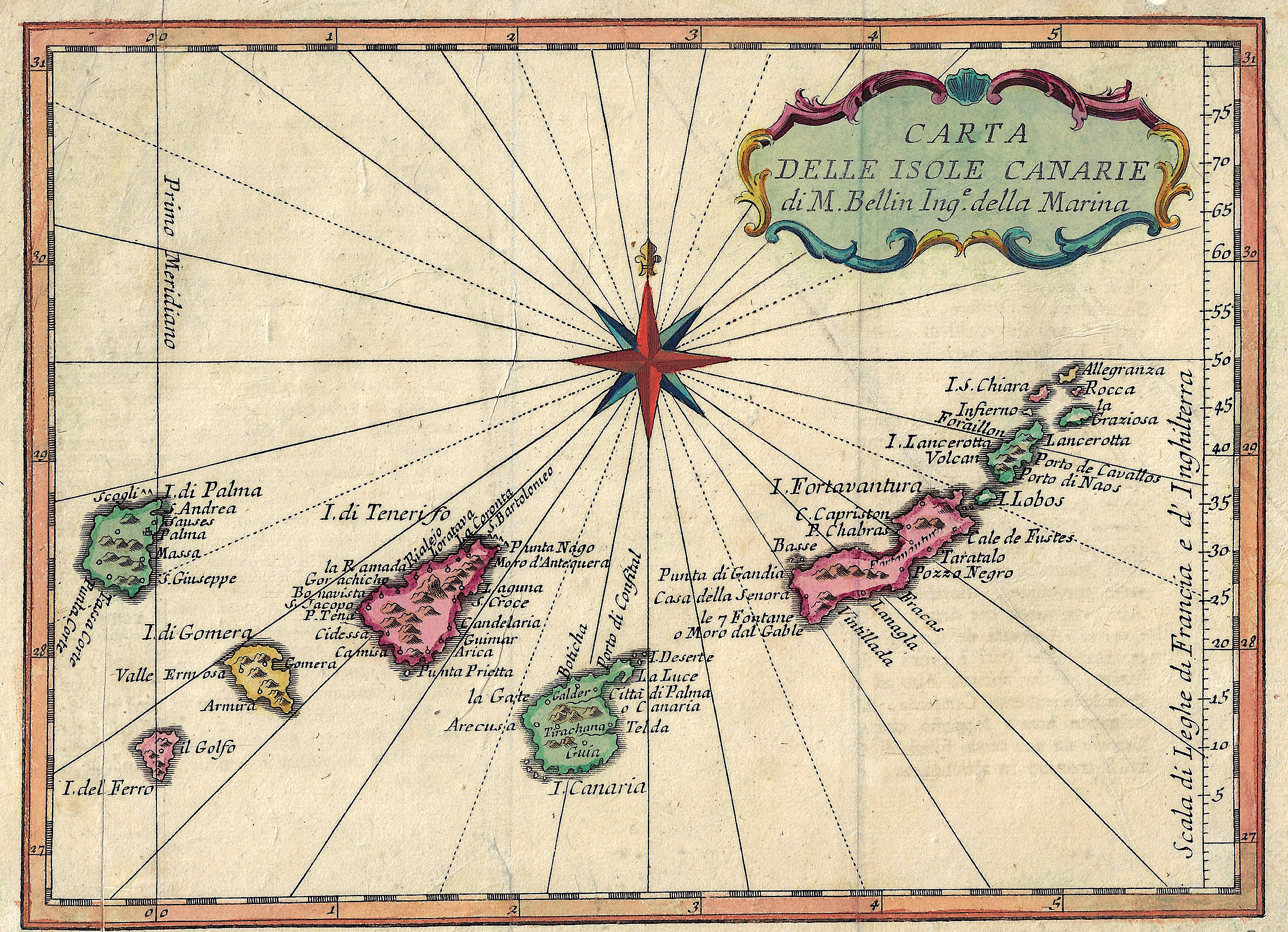
Carta delle Isole Canarie di M. Bellin Inge. Della Marina

| Article ID | EUE4359 |
Title | Carta delle Isole Canarie di M. Bellin Inge. Della Marina |
Description | Map shows the Canary Islands with Teneriffa, Fuerteventura, Gran Canaria, Lanzarote, La Palma, La Gomera und El Hierro. |
| Year | ca. 1740 |
Artist | Bellin (1703-1772) |
Jacques-Nicolas Bellin (1703 Paris -1772 Versailles) was a French cartographer, engineer-geographer, marine hydrographer. As a contributor to the Encyclopédie, he wrote more than a thousand articles on maritime topics. As a cartographer, Bellin distinguished himself primarily in the field of sea cartography. From 1721 he worked for the Dépot des Cartes et Plans de la Marine, from 1741 until his death as an engineer-hydrograph of the Navy. In 1753 his atlas Neptune français, which covered all the coasts of France, was published, and in 1756 the hydrography françoise covering all seas of the earth. In 1764 the five-volume Petit Atlas maritime was published, which Bellin prepared on the orders of the Minister of the Navy, Choiseul. In addition, he wrote a number of geographical works and with Nouvelle méthode pour apprendre la geographie (1769) a geographic textbook for teaching. His maps illustrated, among other things, Bougainville's work Voyage autour du monde, published in 1771. As a co-author of the Encyclopédie edited by Diderot and d'Alembert, Bellin wrote more than a thousand articles in the field of shipping and navy. | |
Historical Description | Canary islands with Teneriffa, Fuerteventura, Gran Canaria, Lanzarote, La Palma, La Gomera und El Hierro. The archipelago also includes a number of islands and islets: La Graciosa, Alegranza, Isla de Lobos, Montaña Clara, Roque del Oeste and Roque del Este. In ancient times, the island chain was often referred to as "the Fortunate Isles". The Canary Islands are the most southerly region of Spain and the largest and most populated archipelago of the Macaronesia region. From the 4th century until the rediscovery of the Canary Islands by the Europeans in the 14th century, different cultures developed independently on the individual islands. These were based on the same principles but had so many special features that one cannot speak of a "culture of the Guanches of the Canary Islands". There was the culture of the Majos in Lanzarote, that of the Majoreros in Fuerteventura, that of the Bimbaches in El Hierro, that of the Gomeros in La Gomera, that of the Canarios in Gran Canaria, that of the Benahoaritas in La Palma and that of the Guanches in Tenerife. The naming of the indigenous people of all islands with the designation of the indigenous people of the island of Tenerife as Guanche, which was common for a long time, ignores the differentiated cultural developments on the different islands. |
| Place of Publication | Paris |
| Dimensions (cm) | 17 x 23 cm |
| Condition | Tear on lower part perfectly restored |
| Coloring | original colored |
| Technique | Copper print |