

Adina Sommer
Antique and Contemporary Art
Winzerer Str. 154
80797 München
telephone
+49 89 304714
business hours:
by appointment
Email
![]()


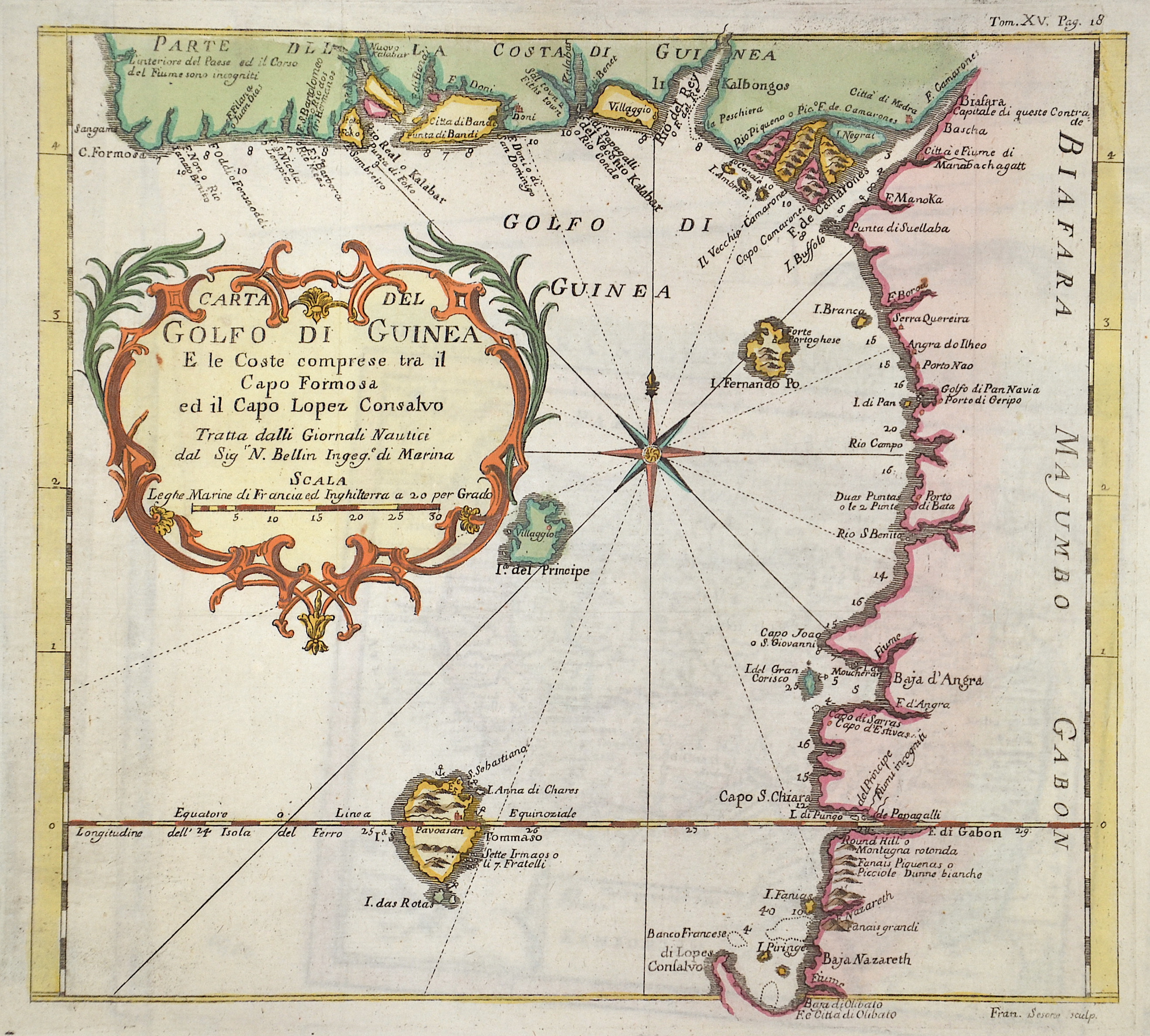
Carta del Gofo di Guinea. E le Coste comprese tra il Capo Formosa ed il Capo Lopez Consalvo

| Article ID | AF0530 |
Title | Carta del Gofo di Guinea. E le Coste comprese tra il Capo Formosa ed il Capo Lopez Consalvo |
Description | Map shows the Gulf of Guinea from the coast of Cape Formosa to Cape Lopez Consalvo. With the states of Nigeria, Kamarun, Equatorial Guinea, Gabon and the island state of São Tomé. Furthermore a title cartouche and a compass rose. |
| Year | ca. 1740 |
Artist | Bellin (1703-1772) |
Jacques-Nicolas Bellin (1703 Paris -1772 Versailles) was a French cartographer, engineer-geographer, marine hydrographer. As a contributor to the Encyclopédie, he wrote more than a thousand articles on maritime topics. As a cartographer, Bellin distinguished himself primarily in the field of sea cartography. From 1721 he worked for the Dépot des Cartes et Plans de la Marine, from 1741 until his death as an engineer-hydrograph of the Navy. In 1753 his atlas Neptune français, which covered all the coasts of France, was published, and in 1756 the hydrography françoise covering all seas of the earth. In 1764 the five-volume Petit Atlas maritime was published, which Bellin prepared on the orders of the Minister of the Navy, Choiseul. In addition, he wrote a number of geographical works and with Nouvelle méthode pour apprendre la geographie (1769) a geographic textbook for teaching. His maps illustrated, among other things, Bougainville's work Voyage autour du monde, published in 1771. As a co-author of the Encyclopédie edited by Diderot and d'Alembert, Bellin wrote more than a thousand articles in the field of shipping and navy. | |
Historical Description | In pre-colonial times, the territory of what is now Cameroon was characterized by ethnic groups of different origins. European influence began in 1472, when Portuguese sailors under the command of the navigator Fernando do Poo landed in the delta of the Wouri River. Because of the many crabs they found there, they named the river Rio de Camarões (Crab River), from which the later name Cameroon is derived. With the emergence of the Portuguese, a lively exchange of goods began around 1520. Trade goods were especially slaves, ivory and palm oil. The main trading partners were the coastal societies such as the Duala, who settled on the Cameroon estuary. In the years following the appearance of the Portuguese, the first sugar cane plantations were established. In addition, the slave trade became increasingly important. It officially ended with the signing of the treaty between the Douala and the British government in 1840. Missionization of Cameroon also began during this period. First explorations in the hinterland started in the middle of the 19th century via the old trans-Saharan routes. The German African explorer Heinrich Barth traveled the Sahara in 1851 on behalf of the Royal Geographical Society of London and also stayed in the north of what later became Cameroon. The military doctor Gustav Nachtigal was among the first explorers to bring news from the Lake Chad region. In 1858, the British missionary Alfred Saker founded a small colony in Ambas Bay together with freed slaves. Cameroon was a German colony from 1884 to 1919. In 1960, after a referendum and the expiration of the UN mandate, French Cameroon gained independence and called itself Eastern Cameroon. The Federal Republic of Cameroon was transformed into a unitary state on 1972 (United Republic of Cameroon). |
| Place of Publication | Paris |
| Dimensions (cm) | 25 x 27 cm |
| Condition | Upper right corner perfectly replaced |
| Coloring | colored |
| Technique | Copper print |