

Adina Sommer
Antique and Contemporary Art
Winzerer Str. 154
80797 München
telephone
+49 89 304714
business hours:
by appointment
Email
![]()


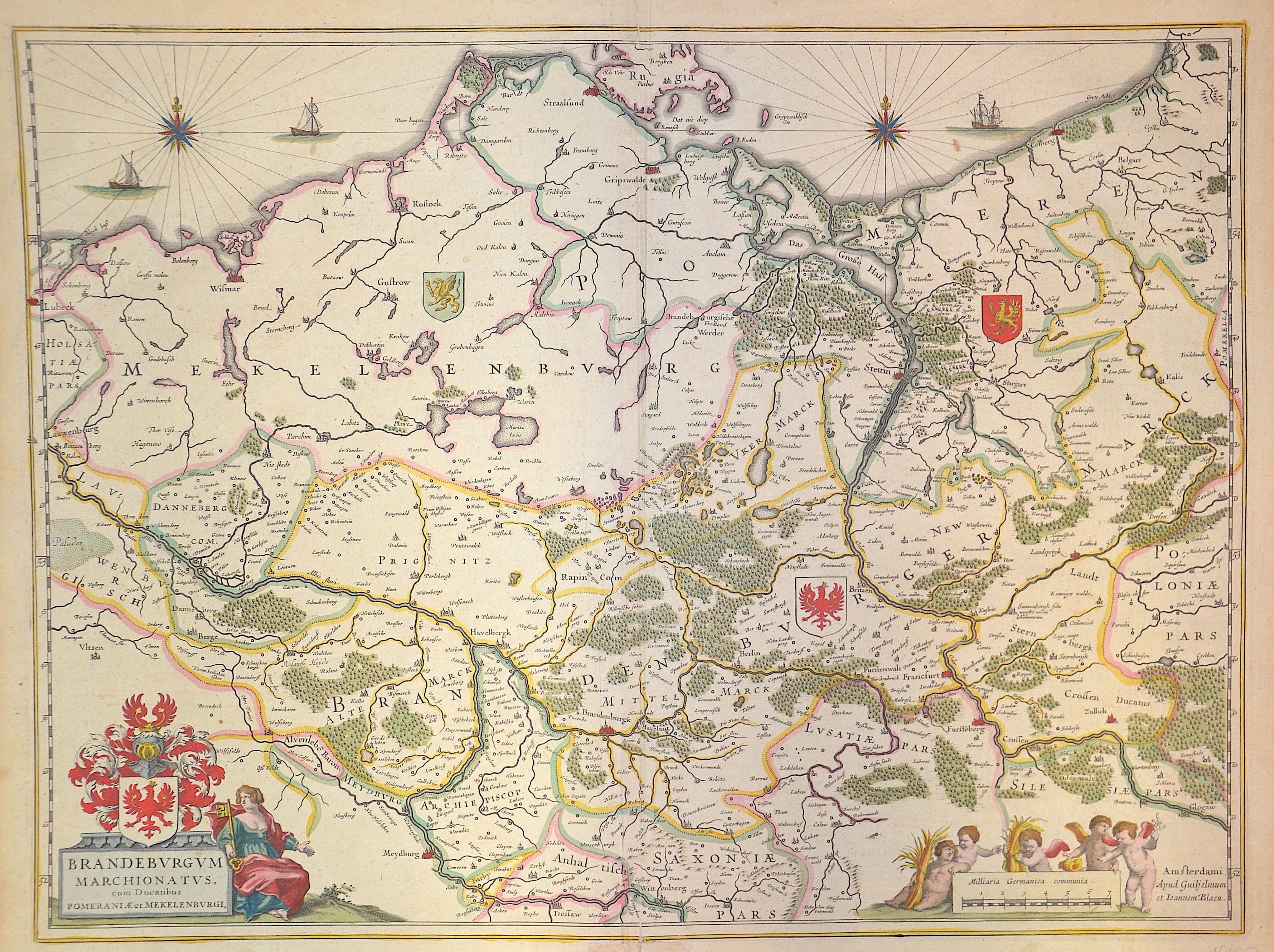
Brandenburgum Marchionatus cum Ducatibus Pomeraniae et Mecklenburgi

| Article ID | EUD0075 |
Title | Brandenburgum Marchionatus cum Ducatibus Pomeraniae et Mecklenburgi |
Description | Map shows Brandenburg with Berlin, Mecklenburg-Western Pomerania, three ship's stations, two wind roses and three coat-of-arms positions in the country. Furthermore, a title cartouche with the Brandenburg eagle in the coat of arms and a mileage indicator cartouche. |
| Year | ca. 1635 |
Artist | Blaeu (1571-1638) |
Joan Guilliemus Blaeu was the eldest son of Willem Janszoon Blaeu (1571-1638), and was probably born in Alkmaar in the province of Noord-Holland in the final years of the 16th century. He was brought up in Amsterdam, and studied law at the University of Leiden before going into partnership with his father in the 1630s. Although his father Willem had cartographic interests, having studied under the Danish astronomer Tycho Brahe and having manufactured globes and instruments, his primary business was as a printer. It was under the control of Joan that the Blaeu printing press achieved lasting fame by moving towards the printing of maps and expanding to become the largest printing press in Europe in the 17th century. By the 1660s the Theatrum Orbis Terrarum (or Atlas Maior as it had became known by this time) had expanded to between 9 and 12 volumes, depending on the language. With over 3,000 text pages and approximately 600 maps, it was the most expensive book money could buy in the later 17th century. The translation of the text from Latin into Dutch, English, German, French, and Spanish for several volumes created enormous work for those involved in typography and letterpress activities. It is estimated that over 80 men must have been employed full-time in the Blaeu printing house in Bloemgracht, not including engravers who worked elsewhere, with over 15 printing presses running simultaneously, and in 1667 a second press was acquired at Gravenstraat. At the same time as producing the Atlas Maior, Blaeu was also publishing town plans of Italy, maps for globes, and other volumes. At its peak the Blaeu press managed to produce over 1 million impressions from 1,000 copper plates within four years. | |
Historical Description | The province of Pomerania, located in the north German lowlands, was the Prussian province formed from the Duchy of Pomerania after the Vienna Congress in 1815. It consisted of western Pomerania and Western Pomerania. Pomerania's capital was Szczecin. Through the Peace of Westphalia in 1648, Hinterpommern came to Brandenburg and Vorpommern became Swedish-Pommern. The Brandenburg Elector Friedrich Wilhelm I succeeded in conquering all of Swedish Pomerania in 1678, but he had to forego the majority of the conquered areas under pressure from France in the Peace of Saint-Germain (1679). After the end of the Great Northern War (1700-1721), the part of Western Pomerania south of the Peene came to Prussia (Old Western Pomerania). During the territorial reorganization of Europe in 1815, the last part of Western Pomerania, which remained Swedish, became Prussian with the island of Rügen (New Western Pomerania). At the same time, Pomerania received the districts of Dramburg and Schivelbein as well as the northern parts of the Arnswalde district with the town of Nörenberg from the Neumark, which otherwise remained with the province of Brandenburg. |
| Place of Publication | Amsterdam |
| Dimensions (cm) | 40 x 53 cm |
| Condition | Some restoration at lower centerfold |
| Coloring | colored |
| Technique | Copper print |