

Adina Sommer
Antique and Contemporary Art
Winzerer Str. 154
80797 München
telephone
+49 89 304714
business hours:
by appointment
Email
![]()


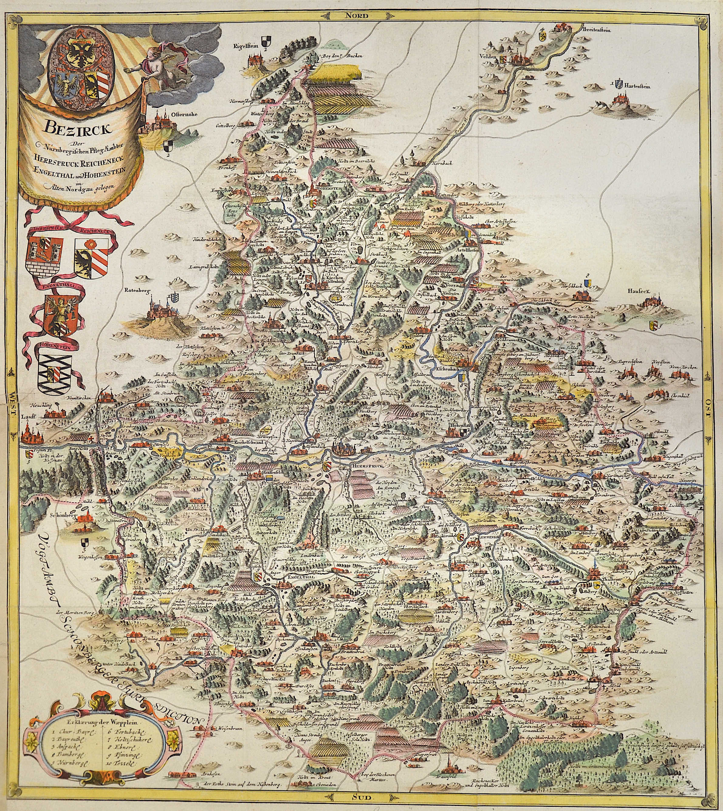
Bezirck der Nürnbergischen Pfleg-Aembter Herspruck, Reicheneck, Engelthal und Hohenstein

| Article ID | EUD0023 |
Title | Bezirck der Nürnbergischen Pfleg-Aembter Herspruck, Reicheneck, Engelthal und Hohenstein |
Description | Map partly shows Franconia. Top left the title cartouche with the coats of arms of the care offices, bottom left explanations. . Showing the care offices of Hersbruck, Reicheneck, Engeltal and Hohenstein. Hersbruck in the centre of the map. The map by Paul Pfinzing served as a model for this map. |
| Year | ca. 1757 |
Artist | Seutter (1678-1757) |
Matthias Seutter (1678- 1757) Augsburg was the son of a goldsmith in Augsburg. In 1697, Seutter began his studies in Nuremberg and subsequently worked in the publishing house of Jeremias Wolff in Augsburg. In 1710, he established his own publishing house and print shop. The Seutter publishing house produced a great number of maps, atlases, and globes. However, very few original maps were printed there, as Augsburg at that time had no university and no connection to the fields of mathematics or the natural sciences. Seutter therefore copied the work of other cartographers, making his own engravings based on their models. Over 500 maps were produced in his studio. Seutter's most well-known works are the 1725 "Geographical Atlas or an Accurate Depiction of the Whole World" ("Atlas Geographicus oder Accurate Vorstellung der ganzen Welt") with 46 maps, the 1734 "Large Atlas" ("Grosser Atlas") with 131 maps, and the 1744 pocket atlas "Small Atlas" ("Atlas minor") with 64 maps. Matthäus Seutter died in 1757. Seutter's son Albrecht Karl, his son-in-law Conrad Tobias Lotter, and his business partner Johann Michael Probst ran the printing business for five more years. | |
Historical Description | The Franconia fell to today's Franconia region with their victories over the Alemanni and Thuringians in their core areas in the 6th century. After the Franconian divisions, the Francia orientialis from the areas of the dioceses of Mainz, Worms, Würzburg and Speyer was added, and later the diocese of Bamberg was added. In the 7th century, the Slavs began to populate the northeastern parts of the region from the east, since the areas of today's Upper Franconia were sparsely populated (Bavaria Slavica). Charlemagne developed the areas around the Main into a royal province. From the middle of the 9th century, the Duchy of the Tribes, one of the five Duchies of the Eastern Franconian Empire, was established. From the 12th century, the Nuremberg Castle was the seat of the castle county of Nuremberg. From around 1190, the burgrave was ruled by the Zollern, the Frankish line of the later Hohenzollern, who represented the German emperor in the 19th and 20th centuries. Franconia already played an important role for the kingship in the time of Rudolf von Habsburg, the Itineraries of the following kings attested to the favoritism of the Rhine-Main region. In 1376 the Swabian Association of Cities was founded, which later also included several Franconian imperial cities. In July 1500, during the reign of Emperor Maximilian I, the empire was divided into imperial circles in the course of the imperial reform movement, which led to the creation of the Franconian imperial circle in 1512. From today's perspective, the Franconian Imperial Circle is sometimes considered to be an important basis for the development of a Franconian sense of community that still exists today. Franconia played an important role in the expansion of Martin Luther's Reformation. From 1552, the margrave Albrecht Alcibiades tried to break the supremacy of the mighty imperial city of Nuremberg and to secularize the possessions of the princes in order to create a duchy that he ruled. Large areas of Franconia were finally devastated in the fighting until King Ferdinand I, with several dukes and princes, decided to subjugate Albrecht. In 1608, Protestant sovereigns united in the Reich to form the so-called Union. The Catholic side reacted in 1609 with a counter-alliance, the league. The contrasts between the two camps eventually led to the Thirty Years' War, which became the greatest burden of cohesion within the Franconian Empire. From 1803 the later Kingdom of Bavaria received large parts of Franconia with the main deputation of the Imperial Deputation under the pressure of Napoleon Bonaparte through secularization and mediatization. Through the Rhine Confederation, Bavaria, Württemberg, Baden and other areas became more closely linked to France, which disintegrated the Holy Roman Empire and the Franconian Empire in 1806. |
| Dimensions (cm) | 60 x 54 cm |
| Condition | Very good |
| Coloring | colored |
| Technique | Copper print |