

Adina Sommer
Antique and Contemporary Art
Winzerer Str. 154
80797 München
telephone
+49 89 304714
business hours:
by appointment
Email
![]()


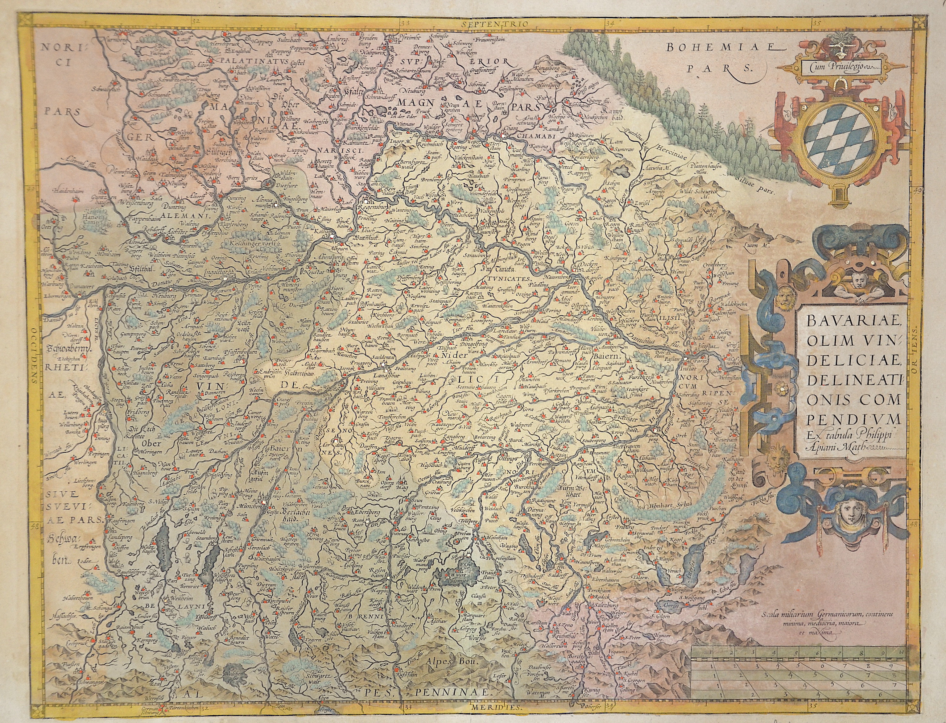
Bavarie olim vindeliciae delineationis com pendium

| Article ID | EUD0505 |
Title | Bavarie olim vindeliciae delineationis com pendium |
Description | Map of Bavaria. From the famous atlas ,Theatrum Oris Terrarum' by Abraham Ortelius in Antwerp 1595, At the right side, in the centre a large decorative title cartouche, above with a cartouche of the Bavariancoat of arm. In the lower right corner a mileage scale. The map of Bavaria is issued after the Landtafeln by Phillip Apian. An important early map of Bavaria, Regensburg and the Danube. Regensburg is located at the geographical northest point of the river Danube. The map shows Bavaria with the neighboring Bohemia, also in the north towards the 'Fichtelgebirge' and Nürnberg. In The cities and towns on the map are shown as miniature views in form of silhouettes. |
| Year | ca. 1590 |
Artist | Ortelius (1527-1598) |
Abraham Ortelius (1527–1598) was a Flemish cartographer and publisher from Antwerp. Originally a map colorist, he became a major figure in cartography through his Theatrum Orbis Terrarum (1570), considered the first modern atlas—a uniform collection of reliable maps in book form. Influenced by Gerardus Mercator, Ortelius published several maps before compiling the Theatrum, which clearly showed America as a separate continent. The work was published in 42 editions and 7 languages by 1612. Unlike many of his peers, Ortelius cited his sources, and his atlas became a milestone in mapmaking and geographic knowledge. | |
Historical Description | The existence of a Bavarian tribal duchy has been documented since 555, which became part of the Frankish domain under the Merovingians. From 1180 to 1918 Bavaria was ruled by the Wittelsbachers as a territorial duchy. Bavaria experienced a period of numerous divisions into individual duchies from 1255 to 1503. Shortly before the first reunification, Ludwig IV. In 1328 became the first Wittelsbacher to become emperor, which meant a new high point in power for Bavaria. At the same time, however, the prince-archbishopric of Salzburg finally separated from the mother country Bavaria. In 1429, after the Straubing-Holland line became extinct, the Duchy of Bavaria-Straubing was divided between the Munich, Ingolstadt and Landshut lines. In 1447, Bavaria-Ingolstadt fell to Bavaria-Landshut, which in turn was won by Bavaria-Munich in the War of Succession in Landshut in 1503. The division of the country came to an end through the Primogenitur Act of Duke Albrecht IV of 1506. Bavaria took a leading position in the Counter-Reformation and emerged from the Thirty Years' War with territorial gains and the rise to the Electorate. In 1620, the troops of the Catholic League, under the leadership of the Bavarian general Tilly, defeated the Protestants in the Battle of the White Mountains near Prague. Then Tilly had the Palatinate occupied. As a thank you, Maximilian I received the electoral title in 1623 and the Upper Palatinate he occupied as war compensation in 1628. After the war, Elector Ferdinand Maria devoted himself to the reconstruction of the devastated country and pursued a cautious neutrality policy. During the War of the Spanish and Austrian Succession and in the course of Maximilian II. Emanuel's great power policy and later his son Karl Albrecht, Austria was twice temporarily occupied by absolutist Bavaria. In 1705 the Bavarian people rose against the imperial occupation. Only the battle of Aidenbach on January 8, 1706 ended with the complete defeat of the popular uprising. After Karl Albrecht's coronation, large parts of the electorate were occupied again until 1744. Karl Albrecht's son Maximilian III. Joseph finally ended the great power policy of his predecessors in 1745 and devoted himself to internal reforms. After the extinction of the old Bavarian line of the Wittelsbacher, the double electorate of Kurpfalz-Bavaria was created in 1777 under the reign of the Elector Karl Theodor from the Palatinate line of the Wittelsbacher. At the time of Napoleon, Bavaria was initially on the side of France and was able to record large territorial gains through secularization and mediatization. Salzburg, Tyrol, Vorarlberg and the Innviertel region, which was lost in 1779, fell temporarily to Bavaria. In the Peace of Pressburg, which was concluded on December 26, 1805 between France and the German Emperor Franz II, Bavaria, allied with Napoleon, was proclaimed a kingdom. King Max I. Joseph's Minister Maximilian Graf von Montgelas is considered the creator of the modern Bavarian state. In 1806 Napoleon Bonaparte elevated Bavaria to a kingdom. At the Vienna Congress in 1814, Bavaria was able to retain a large part of the area's profits as a victorious power, including what was now northern Bavaria, parts of Swabia and the Palatinate. In 1918 the Wittelsbach monarchy collapsed in the November Revolution. King Ludwig I, who had ruled since 1825, developed the Bavarian capital Munich into an art and university city. After the occupation by American troops, Bavaria became part of the newly founded Federal Republic in 1949. |
| Place of Publication | Antwerp |
| Dimensions (cm) | 38 x 48 cm |
| Condition | Very good |
| Coloring | original colored |
| Technique | Copper print |