

Adina Sommer
Antique and Contemporary Art
Winzerer Str. 154
80797 München
telephone
+49 89 304714
business hours:
by appointment
Email
![]()


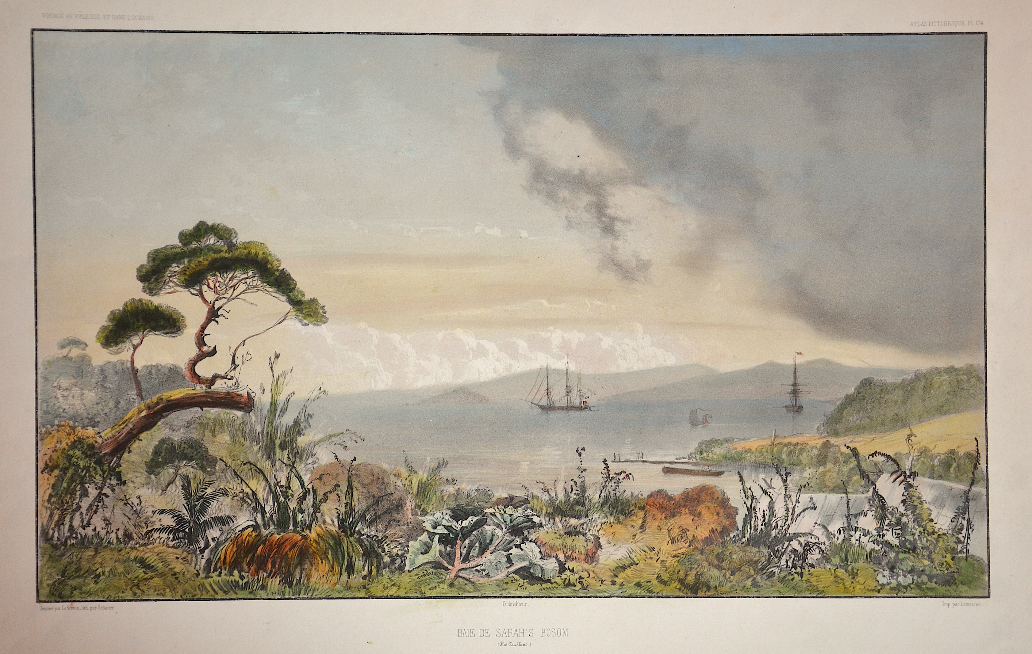
Baie de Sarah’s Bosom. (Iles Auckland.)

| Article ID | OZ0517 |
Title | Baie de Sarah’s Bosom. (Iles Auckland.) |
Description | View shows Port Ross Bay originally known as Sarah's Bosom on Auckland Island near New Zealand. On 11 March 1840, Jules Dumont d'Urville sailed from Hobart to the sub-Antarctic Auckland Islands in command of the French ship Astrolabe. The Astrolabe and the Zélée lay at anchor in this sheltered harbour for eight days in March 1840. While the scientists on board explored the region and collected bird, plant and rock samples, Louis Le Breton recorded the scene. Le Breton was a surgeon and later the official artist on board the Astrolabe, which undertook a scientific expedition to the Southern Hemisphere between 1837 and 1840. He produced more than 170 sketches, which are among the earliest known pictorial records of the Auckland Islands. Many of these were reproduced as lithographs for D'Urville's travelogue Voyage au Pôle Sud et dans l'Océanie (Voyage to the South Pole and Oceania), published between 1842 and 1846. |
| Year | ca. 1825 |
Artist | Lemercier (1803-1887) |
Huge Parisian firm of lithographic printers founded by Joseph Rose Lemercier (1803-1887), who began as the foreman for Langlumé in 1825. Working on his own account from 1827, 1829-36 in partnership with Bénard association formed in 1837 according to IFF catalogue for Joseph Lemercier. The firm was still active in 1841. | |
Historical Description | New Zealand was discovered by Polynesians around the end of the 13th century, or at the latest in the first half of the 14th century, and was settled in several waves of immigration. The descendants of the first immigrants founded the Māori culture. The first Māori to reach the land found no mammals. To feed themselves, they first hunted the moa, a flightless bird remotely similar to the African ostrich. The first European to set eyes on New Zealand was the Dutch navigator Abel Tasman. His mission was to find the "Great Southern Land" because valuable raw materials were suspected there. On his voyage, in 1642, he discovered a "great high land" on the South Island, today's West Coast region. He was not sure and suspected that he had discovered another piece of Staten Landt coast. When he went to Golden Bay in what is now the Tasman region to explore the land up close, he had his first bloody encounter with the "aborigines" in which four Dutch sailors were killed. The "discoverer of New Zealand" never set foot on New Zealand soil. A year later, when an expedition under Hendrik Brouwer determined that the coastal strip found by Tasman did not belong to Staten Landt, the country was named Nova Zeelandia (Latin) or Nieuw Zeeland (Dutch), in reference to Australia, which had been called Nova Hollandia or Nieuw Holland. Like Tasman, the British captain James Cook was to find a suspected southern continent. In 1769, Cook's ship Endeavour, coming from Tahiti, encountered New Zealand at the southwestern point of the bay called Poverty Bay. After first hostile encounters, but then also successful approaches with Māori, Cook first circumnavigated the North Island and, after a longer stay in the Marlborough Sounds, the South Island and was thus able to prove that New Zealand was islands and not part of a continent. Cook and the scientists accompanying him began to map the country thoroughly, they explored flora and fauna extensively and gathered information about the Māori. Only a few weeks after Cook, Jean François Marie de Surville also reached the islands. In the following years, mainly whalers, sealers and later missionaries migrated to New Zealand. These maintained pronounced contacts with the Māori. The two parties engaged in lively trade with each other, and some Europeans also lived together with the Māori. |
| Place of Publication | Paris |
| Dimensions (cm) | 28 x 43 cm |
| Condition | Perfect condition |
| Coloring | original colored |
| Technique | Lithography |