

Adina Sommer
Antique and Contemporary Art
Winzerer Str. 154
80797 München
telephone
+49 89 304714
business hours:
by appointment
Email
![]()


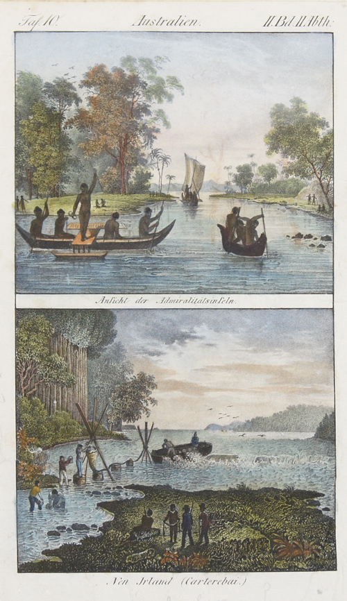
Australien. Ansicht der Admiralitätsinseln / Neu Irland (Carterebai.)

| Article ID | OZ0357 |
Title | Australien. Ansicht der Admiralitätsinseln / Neu Irland (Carterebai.) |
Description | Representation of natives from Admiralty Islands in Papua New Guinea. The Admiralty Islands are an archipelago group of 18 islands in the Bismarck Archipelago, to the north of New Guinea in the South Pacific Ocean. These are also sometimes called the Manus Islands, after the largest island. |
| Year | ca. 1790 |
Artist | Hogg (1778-1824) |
Alexander Hogg (1778-1824) was a publisher of books, maps and prints. He was active in London and worked under the sign of the Kings Arms in Paternoster Row. He became known for his publications of James Cook's voyages of discovery. | |
Historical Description | Independent State of Papua New Guinea, is an oceanic country that occupies the eastern half of the island of New Guinea and its offshore islands in Melanesia, a region of the southwestern Pacific Ocean north of Australia. The Portuguese Jorge de Meneses, who explored the north coast and offshore islands in 1526/27, is considered the island's European explorer. In 1545 the Spaniard Íñigo Ortiz de Retez landed and named the island "New Guinea" because the coast reminded him of that of the African Guinea, which he had previously passed. In 1623 Jan Carstenszoon mapped large parts of the coast on behalf of the Dutch East India Company. Since then, the Dutch East India Company has maintained business and political contacts with the region and the Sultanate of Tidore. |
| Place of Publication | London |
| Dimensions (cm) | 23,5 x 13 |
| Condition | Very good |
| Coloring | original colored |
| Technique | Lithography |