

- Alsace
- Aquitaine
- Auvergne
- Bourgogne
- Bourgogne-Franche-Comte
- Brittany
- Centre
- Champagne
- France Islands
- Gascogne
- Gironde
- Hauts-de-France
- Ile de France
- Languedoc
- Lothringen
- Midi-Pyrénées
- Nivernais
- Nord-Pas-de-Calais
- Normandie
- Occitanie
- Pas-de-Calais
- Pays de la Loire
- Picardie
- Poitou-Charentes
- Provence-Alpes-Cote d Azur
- Pyrénées
- Rhone- Alpes
- Saintonge
- Savoyen
- Tourain
- Westcoast
Adina Sommer
Antique and Contemporary Art
Winzerer Str. 154
80797 München
telephone
+49 89 304714
business hours:
by appointment
Email
![]()


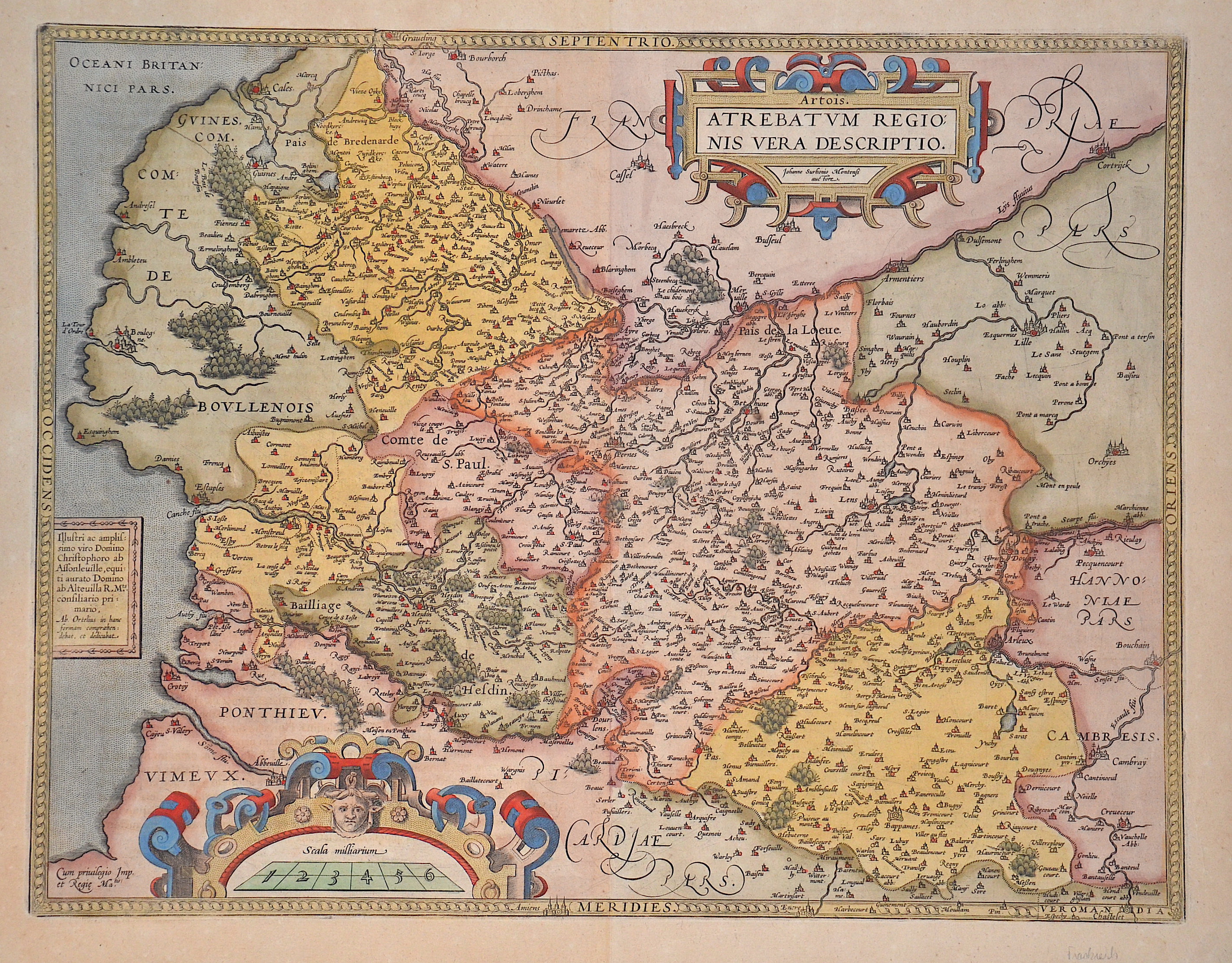
Atrebatum Regionis vera descriptio.

| Article ID | EUF5160 |
Title | Atrebatum Regionis vera descriptio. |
Description | Map shows the historical region of Artois, located in the Pas-de-Calais department in France. Magnificent title cartouche at the top right and a mile marker cartouche at the bottom left. The dedication cartouche in the middle on the left side identifies this sheet as van den Broecke 74. |
| Year | ca. 1584 |
Artist | Ortelius (1527-1598) |
Abraham Ortelius (1527–1598) was a Flemish cartographer and publisher from Antwerp. Originally a map colorist, he became a major figure in cartography through his Theatrum Orbis Terrarum (1570), considered the first modern atlas—a uniform collection of reliable maps in book form. Influenced by Gerardus Mercator, Ortelius published several maps before compiling the Theatrum, which clearly showed America as a separate continent. The work was published in 42 editions and 7 languages by 1612. Unlike many of his peers, Ortelius cited his sources, and his atlas became a milestone in mapmaking and geographic knowledge. | |
Historical Description | Pas-de-Calais is one of the 83 departments created in 1790 during the French Revolution in application of the law of December 1789. It was created by merging Artois and parts of Picardy, the Boulonnais and part of the Ponthieu. |
| Place of Publication | Antwerp |
| Dimensions (cm) | 38 x 49 cm |
| Condition | Perfect condition |
| Coloring | original colored |
| Technique | Copper print |