

Adina Sommer
Antique and Contemporary Art
Winzerer Str. 154
80797 München
telephone
+49 89 304714
business hours:
by appointment
Email
![]()


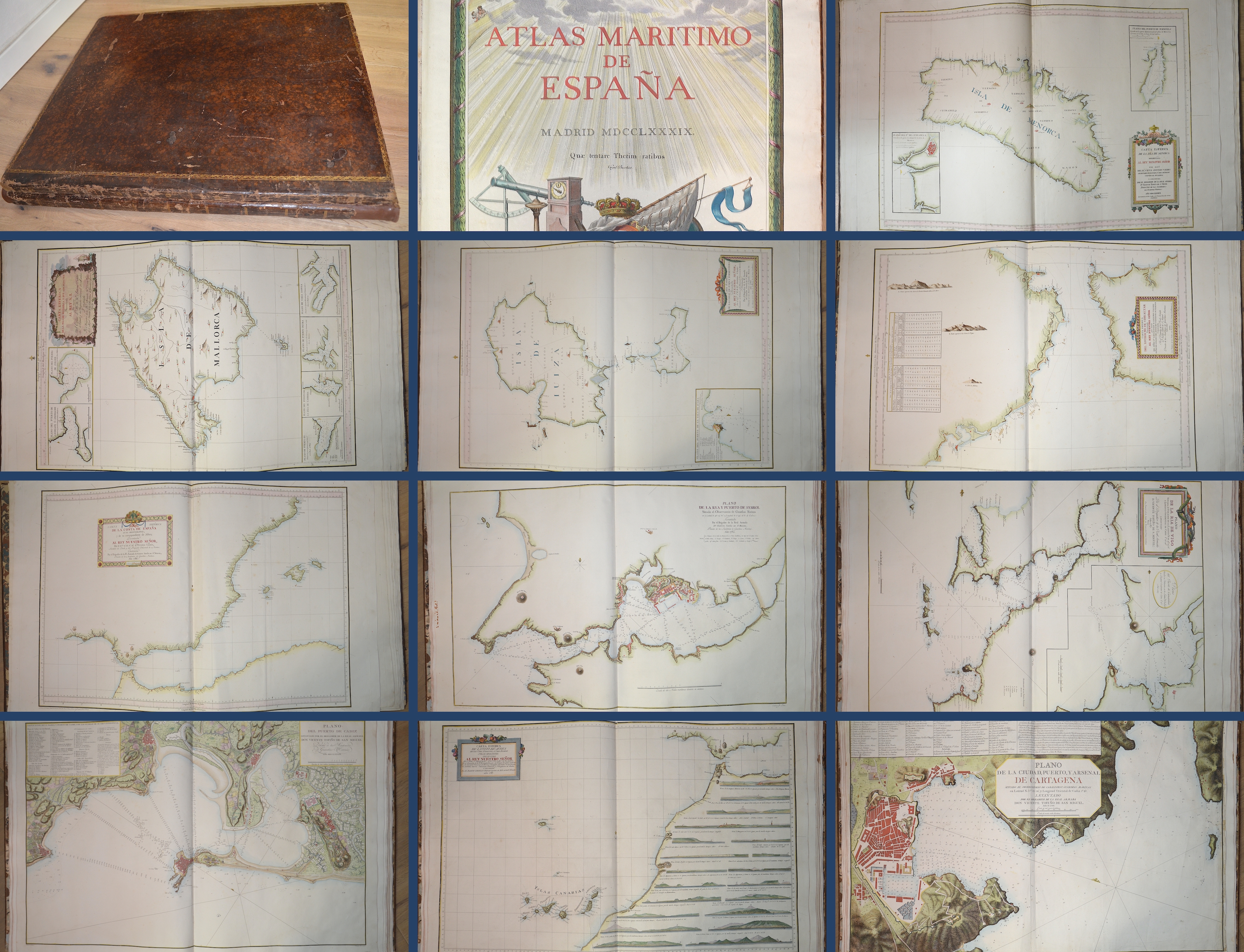
Atlas Maritimo de Espana-Atlas hidrografico de las costas de España en el Mediterraneo

| Article ID | B0241 |
Title | Atlas Maritimo de Espana-Atlas hidrografico de las costas de España en el Mediterraneo |
Description | Atlas maritimo de España. 2 vols. Madrid (1788-)1789. large-format folio (44 p.). Volume I. 30 double-sheet large colored copper maps with engraved title page and and -plans, and in Volume II. 14 double-sheet large copper maps, magnificently colored. Coastal profiles, elevation maps and islands. Inside edges gilt, gold-stamped cover borders. Perfect copy with wide margins. Vol. 1 contains title page and the Atlantic coasts including maps of the Canary Islands and the Azores and the bays of Santander, San Sebastian, Bilbao and Carthagena (loosely enclosed here). Volume.2 contains the coastal maps of the Mediterranean from Gibraltar to Rosas including maps of the Balearic Islands with Majora ,Menorca, Ibiza. Tofiño de San Miguel is the most famous Spanish maritime cartographer. His maps are finely engraved, and besides the mention of Tofiño's name in the title, there are usually other signatures that mention the name of the draftsman or engraver. One of the atlases includes 14 double-page maps of the Mediterranean coast - mostly dated 1786 - and 4 coastal profile views, also double-page. Notable among the maps are those of Gibraltar, Algeciras, the Balearic Islands, Ibiza, Mallorca and Menorca, Mahon. The second part covers the north and west coasts of Spain, the adjacent islands in the Atlantic Ocean and the north of Africa. It was commissioned by King Carlos III, King of Naples and Sicily (1734-1759) and of Spain (1759-1788) on the advice of Antonio Valdes, Minister of the Navy. The work was entrusted in June 1783 to Tofino, then brigadier general in charge of the Ensign Academy. The first volume appeared in 1787 without a title page and the second in 1789 without text. It was such a success that in the same year a second edition of the entire work, the complete Pilot, was published, this time with the text and two more maps." The marine atlas was the first to be published by the Spanish Crown, which was known for its strict policy of secrecy regarding its maritime and cartographic knowledge. It is probably the most important cartographic production of the 18th century in Spain and a foundation of modern Spanish cartography. One of the most important works of Vicente Tofino de San Miguel, a cartographer and navigator born in Cadiz. Drawn by Rafael Mengs. Engraved frontispiece in vol. 1. Both volumes together contain 44 copper engraved nautical charts, plans and profiles, printed on double or single sheets, dated 1786-1789. Main meridians: Cadiz, Ferrol and Paris. Engraved by Manuel Salvador Carmona. Joseph Varelay Ulloa, Fernando Selma, Felipe Bauza, Bartolome Vazquez, Drouet, Santiago, Joaquin Ballester, Juan de la Cruz Cano y Olmedilla, Josef Asensio. Covered are the coasts of Spain, the Atlantic, the Mediterranean, the coast of Portugal, part of Africa, as well as the Canary Islands, the Azores, the Terceras and Cape Verde. The timing of the publication of this atlas is not accidental, because Spain had always been weary of the publication of maps, fearing that hostile or competing states would learn its cartographic secrets, and had imposed a censorship on the publication of maps since the time of the Hasburgs, which changed with the accession of Charles III. changed, It was he who lifted the censorship, which allowed the publication of the maps of the Malaspina expedition, the Portulano de la America Setentrional and, of course, this magnificent marine atlas, which, in addition to its cartographic accuracy, is also a very beautiful print, decorated with beautiful baroque cartouches and frames. Although they are separate works, they are part of the same cartographic endeavor that aimed at a serious and accurate knowledge of the ports of Spain, the Mediterranean and North Africa.... In the European cartographic production, the marine atlases have always occupied a place of honor, their purpose, the practical application for navigation, has determined the balance in favor of geographical precision over beauty. |
| Year | c. 1789 |
Artist | Tofiño de San Miguel (1732-1795) |
Vicente Tofiño de San Miguel and Wanderiales (1732 - 1795 Cadiz) was a Spanish navigator and cosmographer. He studied experimental physics and then joined the army, which he subsequently left. In 1755, Jorge Juan asked Tofiño to join the faculty of the Academy of Marines in Cadiz (Academia de Guardia Marinas de Cádiz) as a mathematics teacher, and allowed Tofiño to join the Armada as a second lieutenant (alférez de navío). In 1768, Tofiño was appointed director of the Academy, and in 1773, director of the Academies of Ferrol and Cartagena. He participated in the expeditions against Algiers (1773) and the Great Siege of Gibraltar (1782). He received the rank of brigadier of the Armada in 1784 and the rank of rear admiral in 1789. Tofiño went to sea and the result was several works, including: Derrotero de las costas de España en el mar Mediterráneo y África (1787) (colección de cartas esféricas de las costas de Espana y Africa ... (1788), a collection of nautical charts of the coasts of Spain and Africa Likewise: Derrotero de las costas de España and El Océano Atlántico y de las islas Azores o Terceras , para inteligencia y uso de las cartas esfericas (1789), a pilot log of the coasts of Spain in the Atlantic and the Azores for the use of naval intelligence and nautical charts. | |
Historical Description | The term Atlas goes back to Gerhard Mercator and his work Atlas sive Cosmographicae Meditationes de Fabrica Mundi et Fabricati Figura, published posthumously in 1595 ("Atlas or cosmographic considerations about the creation of the world and the form of it"). In the foreword, Mercator explains the naming of his work in relation to the mythical King Atlas of Mauritania, who appears to Diodorus Siculus as a wise connoisseur of the stars and their spherical shape. Atlas of Mauritania belongs to the legendary circle around the Titan Atlas. As early as 100 AD, Marinus von Tyrus introduced the grad network card. Around 50 years later, Claudius Ptolemy made a kind of atlas. The beginning of the great voyages of discovery heralded a new development in cartography. Until the 15th century, maps were based on the classic works of Ptolemy (2nd century AD) and atlases, any collection of linked maps. The first atlas, in the sense of a book that was published in a specific edition with cards of the same format that were specially designed or produced for this edition, was Theatrum Orbis Terrarum (i.e. world stage) by Abraham Ortelius (1527–1598) , 1570 appeared in Antwerp, a tome with 70 current maps, which were coordinated in terms of content. 41 editions are known, which were published in different languages until 1612. Such an atlas was that of Gerhard and Cornelis de Jode: Speculum Orbis Terrarum. The first to use Atlas as a title for a similar work was Gerhard Mercator (1512–1594, still known from the projection of the same name, 1569), who was born in Rupelmonde in Flanders and who wrote the atlas published shortly after his death, sive Cosmographicae Meditationes de Fabrica Mundi and Fabricati Figura. France: The golden age is called the heyday of the 17th century in Holland. But the end of this era was also the end of the leading position of the Dutch in the field of Atlas cartography. Atlases were reissued, but not kept up to date. The dominance was taken over by France, which was then predominant in science and art. Already in 1652 Nicolas Sanson (1600–1667) and Pierre Mariette (1603–1657) published an atlas, which in 1658 was followed by the Cartes générales de toutes les parties du monde (Paris, 1658, with 113 cards, six more editions until 1676) which the Dutch atlases surpassed in reliability and timeliness. Triangulation has greatly improved the accuracy of the maps. A first example of this is the atlases by Nicolas de Fer (1646-1720), who wrote his Atlas curieux ou le monde dressé (Paris, 1699, 2 vols with 295 panels), based on the latest survey data from the French Académie des sciences and these Also had data checked by astronomers. The Atlas Nouveau by Guillaume Delisle (1675–1726), which appeared in Amsterdam in 1730, had 56 cards; in later editions extended to 138. Delisle maintained relationships with scholars and authorities around the world (including the Russian Tsar Peter the Great) with the intention of acquiring original templates for his cards. The famous cartographer Jean-Baptiste Bourguignon d’Anville (1697–1782) not only used up-to-date geodetic data, but also, after a critical examination, reports from explorers. His Atlas Général (1780, 46 sheets) is known. Rigobert Bonne (1727–1794), who is still famous due to the map projection named after him, made a name for himself with the Atlas modern ou collection de cartes sur toutes les parties du globe terrestre (Paris, 1771) and with Nicolas Desmarest (1725–1815) wrote a three-volume atlas for the new edition (Paris, 1787/88) published by Panckouke of the famous Encyclopédie by Diderot and d'Alembert. England: The most famous 18th century English atlases were New and Compleat Atlas (1720, 27 maps) by Herman Moll, New General Atlas (1721, 48 plates) by Senex, General Atlas (1770) and New Universal Atlas (1790) by Kitchin, General Atlas of the four grand quarters of the World (1778, later General Atlas of the World) von Faden, u. a. However, they cannot be compared to the French atlases in the same period. Germany:World map from the Atlas portatilis (1717–1780) by Melissantes and Johann Christoph Weigel. The scientific value of the atlases that appeared in Germany in the 18th century was limited. The best-known cartographer and publisher was Johann Baptist Homann (1664–1724) from Nuremberg, who published several large atlases, such as the Great Atlas of the Whole World (1716, 126 maps). His heirs expanded the publishing house with a 3-volume Atlas geographicus maior (1740), which also contained works by others. A student of Homann, Mattias Seutter (1678–1756) from Augsburg published various atlases, for example an Atlas Geographicus (1720) with 46 maps, which was published several times. In general, however, Seutter's works are not very original and mostly reproductions. The small two-part ATLAS PORTATILIS by Johann Christoph Weigel (copperplate engraver) and Johann Gottfried Gregorii alias MELISSANTES (text author) underwent several editions between 1717/1723 and 1780. The second part, called Continuirter ATLAS PORTATILIS GERMANICUS, was somewhat accurate due to the partial use of the good templates by Adam Friedrich Zürner, which also explains the decades of use of these handy pocket and school atlases. Austria: It was only in Austria at the end of the 18th century that there was talk of its own Atlas culture. The best-known works are Schrämbl's General Great Atlas (Vienna, 1786 and later, 133 maps) and probably the most name-rich Atlas of all time, the scene of the five parts of the world, published by Franz Johann Joseph von Reilly (Vienna, 1789 and later) 830 plates that were not fully finished. |
| Place of Publication | Madrid |
| Dimensions (cm) | 63,5 x 49 cm |
| Condition | Binding in cowhide, gold embossed |
| Coloring | original colored |
| Technique | Copper print |