

Adina Sommer
Antique and Contemporary Art
Winzerer Str. 154
80797 München
telephone
+49 89 304714
business hours:
by appointment
Email
![]()


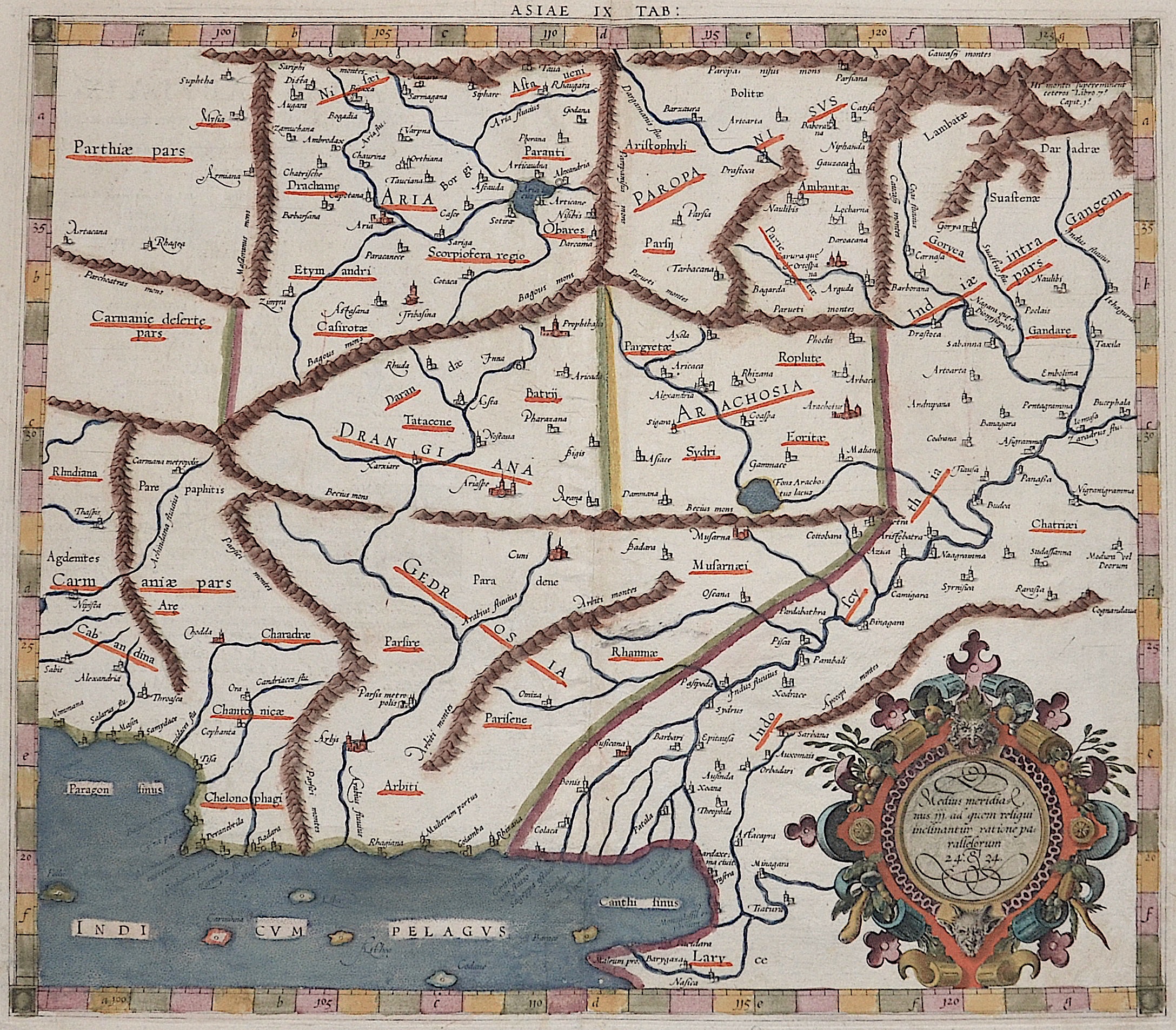
Asiae Tabula IX / Medius meridianus jjj ad quem resiqui inclinantur..

| Article ID | ASP0759 |
Title | Asiae Tabula IX / Medius meridianus jjj ad quem resiqui inclinantur.. |
Description | Map shows Pakistan with the river Indus, Afgansitan and partly Iran. |
| Year | ca. 1584 |
Artist | Ptolemy/ Gerhard Mercator (1512-1594) |
Gerardus Mercator (1512 - 1594) He was a cartographer, philosopher and mathematician. He is best known for his work in cartography, in particular the world map of 1569 based on a new projection which represented sailing courses of constant bearing as straight lines. He is renowned to the present day as the cartographer who created a world map based on a new projection which represented sailing courses of constant bearing as straight lines. In his own day he was the world's most famous geographer but in addition he had interests in theology, philosophy, history, mathematics and magnetism as well as being an accomplished engraver, calligrapher and maker of globes and scientific instruments. He wrote few books but much of his knowledge is to be found in the copious legends on his wall maps and the prefaces that he composed for his atlas ,the first in which the term ""atlas"" appears and the sections within it." Claudius Ptolemy ( arround 100- 160 a.C.) Geographia, gives a list of geographic coordinates of spherical longitude and latitude of almost ten thousand point locations on the earth surface, as they were known at his times. The list is organized in Tabulae which cor- respond to specific regions of the three known continents at that time, Africa, Asia and Europe. Research on Ptolemy’s Geographia has started at the University of Thessaloniki, Greece, in the eighties, focused mainly, but not exclusively, on data re- lated to territories which are now under the sovereignty of the modern Greek state. The World of Ptolemy is classified in Regions, since each Chapter is referred to one of them, giving by this way the concept of Atlas as it is understood today. | |
Historical Description | Around the middle of the 2nd millennium BC The Aryans from Central Asia invaded Pakistan. They shaped Vedic culture and Hinduism. Today's Pakistani territory already came into contact with Islam in the early 8th century when the Arabs conquered the Indus Valley under Muhammad ibn al-Qasim in 712. For centuries the border between the Islamic world and the Indian culture was east of the Indus. The Punjab initially remained outside the Muslim sphere of influence. It was only around 1000 that the Turkish Ghaznavid dynasty extended its empire to the whole of Pakistan and parts of northern India. Until the beginning of the 19th century, Pakistan was part of various Islamic empires, including those of the Persian Ghurids (12th and 13th centuries), the North Indian Delhi Sultans (13th and 14th centuries) and Mughals (16th to 18th centuries) ) and the Afghan Durrani dynasty (18th and 19th centuries). |
| Place of Publication | Duisburg |
| Dimensions (cm) | 34,5 x 39 |
| Condition | Very good |
| Coloring | original colored |
| Technique | Copper print |