

Adina Sommer
Antique and Contemporary Art
Winzerer Str. 154
80797 München
telephone
+49 89 304714
business hours:
by appointment
Email
![]()


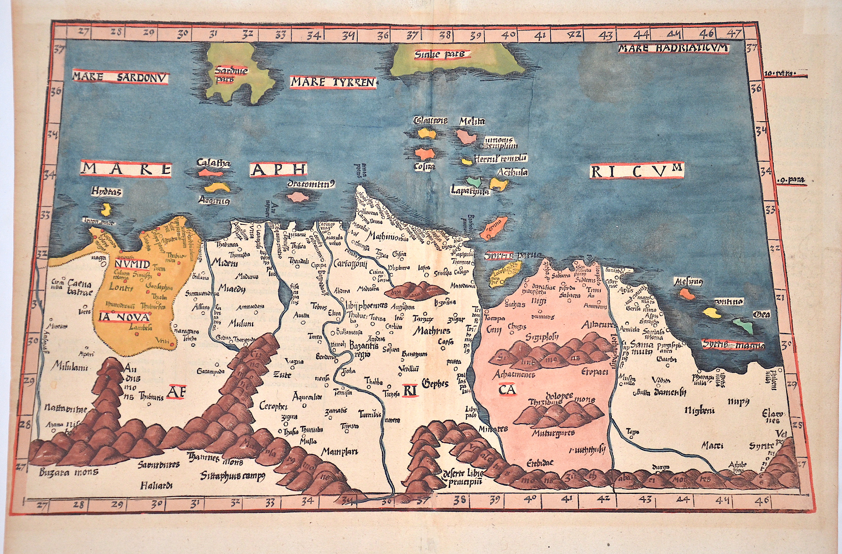
Aphricae Tabula secunda continent

| Article ID | AF0307 |
Title | Aphricae Tabula secunda continent |
Description | Map shows in trapezoid north Africa and the neighbouring countries. With the Mediterranean Sea and partly the islands of Sicily and Sardinia. Rivers and mountains are roughly shown. -On reverse the description with splendour-fully decorated letters. The typical Ptolomey watermark on the right side. |
| Year | ca. 1513 |
Artist | Ptolemy/Waldseemüller- Johann Schott (1477-1550) |
Johann Schott (1477–1550) reissued Martin Waldseemüller’s maps, including 20 detailed regional maps in his atlas Tabula Moderna Germanie, making it one of the most important works of its time. Schott is also known for the atlases Alexandri Magni and Margarita philosophica. Martin Waldseemüller (born c. 1470s, Radolfzell, Germany) studied at Freiburg University and later moved to Lorraine, France, where he joined the intellectual circle Gymnasium Vosagense. He died in 1522. Waldseemüller created the 1507 wall map that first named America and completed maps for a 1513 edition of Ptolemy’s Geography. His atlas merged cartographic science with printing art and included 20 modern maps alongside Ptolemaic ones, using a new quadratic projection. Johannes Schott printed the atlas, with Waldseemüller providing the drawings. Editors Jacobus Äschler and George Uebel worked on the text. Supported by René, Duke of Lorraine, Waldseemüller developed new maps abandoning Ptolemy’s projection for rectilinear meridians and parallels. Due to the Duke’s death, printing was delayed until 1512. The atlas included 26 classical Ptolemaic maps plus 20 new ones published separately. The New World map was based on recent, reliable information attributed to “The Admiral,” believed to be Columbus, leading to the atlas being called the Admiral Atlas. Schott printed a version with minor corrections in Augsburg. Ptolemy’s Geographia (c. 100–160 AD) listed geographic coordinates for nearly 10,000 locations across Africa, Asia, and Europe, organized into regions—an early concept of an atlas. Research on this work, notably at the University of Thessaloniki, continues today. Most maps bear a watermark of a triple-pointed crown. | |
Historical Description | North Africa in the broader geographical sense is the area of the continent of Africa that includes the Sahara and the coastal strip to the north, west and east of the Mediterranean, the Atlantic and the Red Sea. Religiously, North Africa is mainly characterized by Islam, ethnically by Berbers, Moors and Arabs, in the southernmost area also Nubians, Amhars and Black Africans. The core states of North Africa include Morocco with the Western Sahara, Algeria, Tunisia (small Maghreb), Libya (Greater Maghreb), Egypt and Sudan. Especially during the ongoing desert phase, contacts between North and sub-Saharan Africa were therefore limited almost exclusively to trade along the east and west coasts of the continent and to certain routes where there were sufficient water points, due to the difficulties of crossing the world's largest sandy desert. At the same time, this meant ethnic separation, and although North African culture has both African and Middle Eastern roots, with the Berbers possibly even European. With antiquity in the narrower sense, the interests of the Mediterranean peoples, which had previously been focused primarily on Egypt and the Near East in terms of power politics, gradually changed. As so often in history, it was trade that paved new paths; and the first people to devote themselves entirely to Mediterranean trade, even to the neglect of their own state structures, were the Phoenicians, but the place in North Africa where territorial state structures did develop, at least to some extent, was Carthage. In the period between the destruction of Carthage and Rome taking control of the Maghreb, there was a brief flourishing of local kingdoms. Two largely sedentary ethnic groups, the Moors and Numidians, were of particular importance. After the victory over Carthage, Roman culture and, above all, Roman administration spread relatively quickly from east to west along the Atlas mountain ranges across the new territories in North Africa. The North African provinces quickly became economically central to the Roman Empire, and between the 1st and 4th centuries AD, Rome's survival actually depended on grain and olive supplies from there, as the climate in North Africa at that time was wetter than it is today. When the Romans took power in the Mediterranean, a development came to an end in the course of which North Africa in particular finally became part of the Mediterranean world. |
| Place of Publication | Strassburg |
| Dimensions (cm) | 28 x 46,5 cm |
| Condition | Some browning |
| Coloring | original colored |
| Technique | Woodcut |