

Adina Sommer
Antique and Contemporary Art
Winzerer Str. 154
80797 München
telephone
+49 89 304714
business hours:
by appointment
Email
![]()


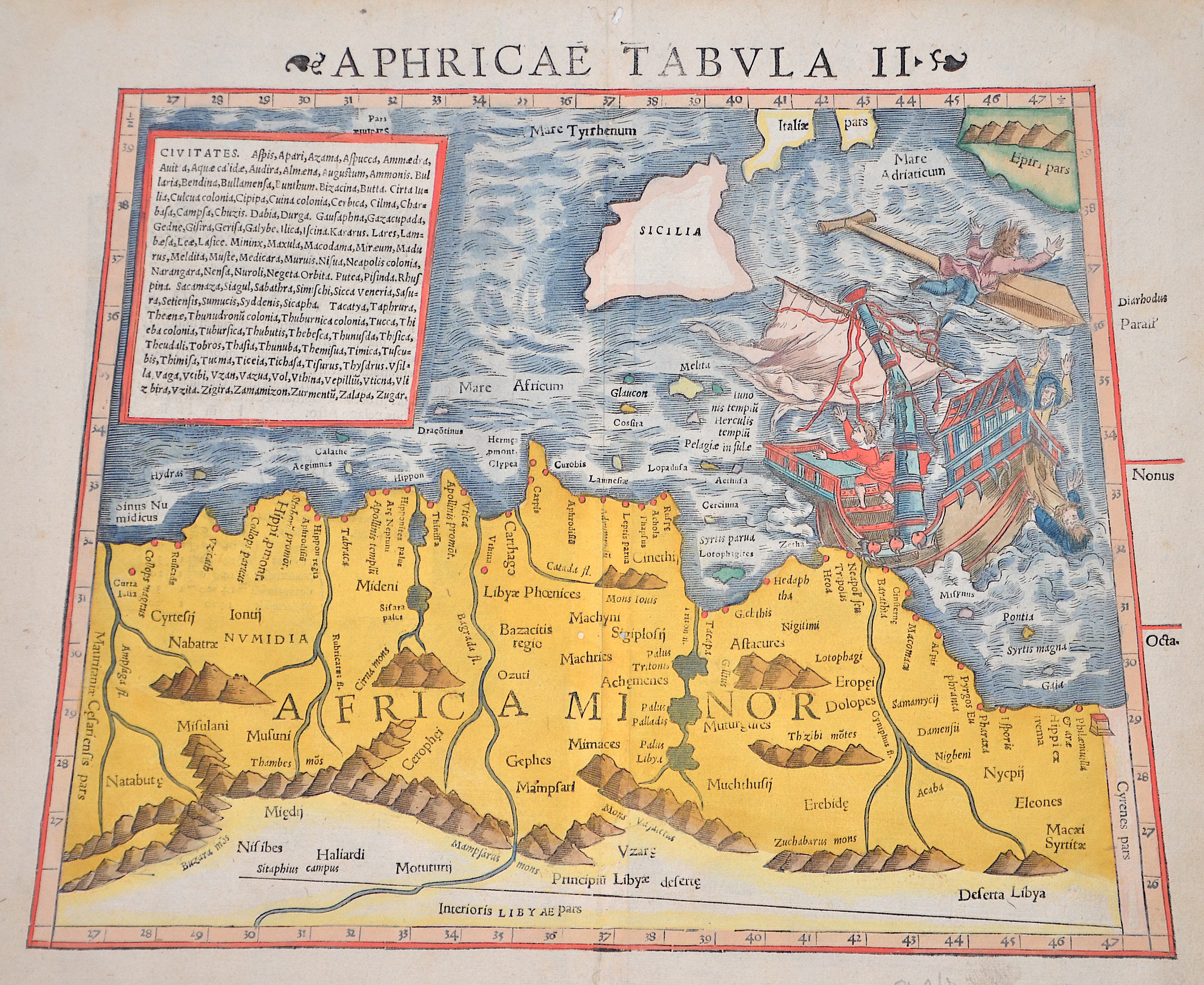
Aphricae tabula II

| Article ID | AF0403 |
Title | Aphricae tabula II |
Description | Map shows North Africa with the countries Algeria, Tunisia, Libya, partly Egypt, Sicily and a sailing ship in distress. |
| Year | ca. 1550 |
Artist | Ptolemy/Münster Sebastian (1489-1552) |
Sebastian Münster (1489–1552) was a prominent Renaissance cosmographer. His Cosmographia, published in 1544 with 24 double-page maps based on research from around 1528, was continuously expanded. It was the first widely accessible scientific description of the world in German, combining knowledge from history, geography, astronomy, and natural sciences. The work remained popular for a long time and was published in many editions and languages until 1650. Claudius Ptolemy (c. 100–160 AD) was a Greek mathematician, geographer, and astronomer. His works on astronomy, geography, and astrology were long considered standard references. He described the Earth as the center of the universe (Centrum Mundi) and established the basis for latitude measurement. His Geographia included the known world and the hypothesis of Terra Australis. Ptolemy provided written instructions for mapmaking but made only rough sketches himself; later maps were created under his name. | |
Historical Description | North Africa in the broader geographical sense is the area of the continent of Africa that includes the Sahara and the coastal strip to the north, west and east of the Mediterranean, the Atlantic and the Red Sea. Religiously, North Africa is mainly characterized by Islam, ethnically by Berbers, Moors and Arabs, in the southernmost area also Nubians, Amhars and Black Africans. The core states of North Africa include Morocco with the Western Sahara, Algeria, Tunisia (small Maghreb), Libya (Greater Maghreb), Egypt and Sudan. Especially during the ongoing desert phase, contacts between North and sub-Saharan Africa were therefore limited almost exclusively to trade along the east and west coasts of the continent and to certain routes where there were sufficient water points, due to the difficulties of crossing the world's largest sandy desert. At the same time, this meant ethnic separation, and although North African culture has both African and Middle Eastern roots, with the Berbers possibly even European. With antiquity in the narrower sense, the interests of the Mediterranean peoples, which had previously been focused primarily on Egypt and the Near East in terms of power politics, gradually changed. As so often in history, it was trade that paved new paths; and the first people to devote themselves entirely to Mediterranean trade, even to the neglect of their own state structures, were the Phoenicians, but the place in North Africa where territorial state structures did develop, at least to some extent, was Carthage. In the period between the destruction of Carthage and Rome taking control of the Maghreb, there was a brief flourishing of local kingdoms. Two largely sedentary ethnic groups, the Moors and Numidians, were of particular importance. After the victory over Carthage, Roman culture and, above all, Roman administration spread relatively quickly from east to west along the Atlas mountain ranges across the new territories in North Africa. The North African provinces quickly became economically central to the Roman Empire, and between the 1st and 4th centuries AD, Rome's survival actually depended on grain and olive supplies from there, as the climate in North Africa at that time was wetter than it is today. When the Romans took power in the Mediterranean, a development came to an end in the course of which North Africa in particular finally became part of the Mediterranean world. |
| Place of Publication | Basle |
| Dimensions (cm) | 27 x 34 cm |
| Condition | Perfect condition |
| Coloring | colored |
| Technique | Woodcut |