

Adina Sommer
Antique and Contemporary Art
Winzerer Str. 154
80797 München
telephone
+49 89 304714
business hours:
by appointment
Email
![]()


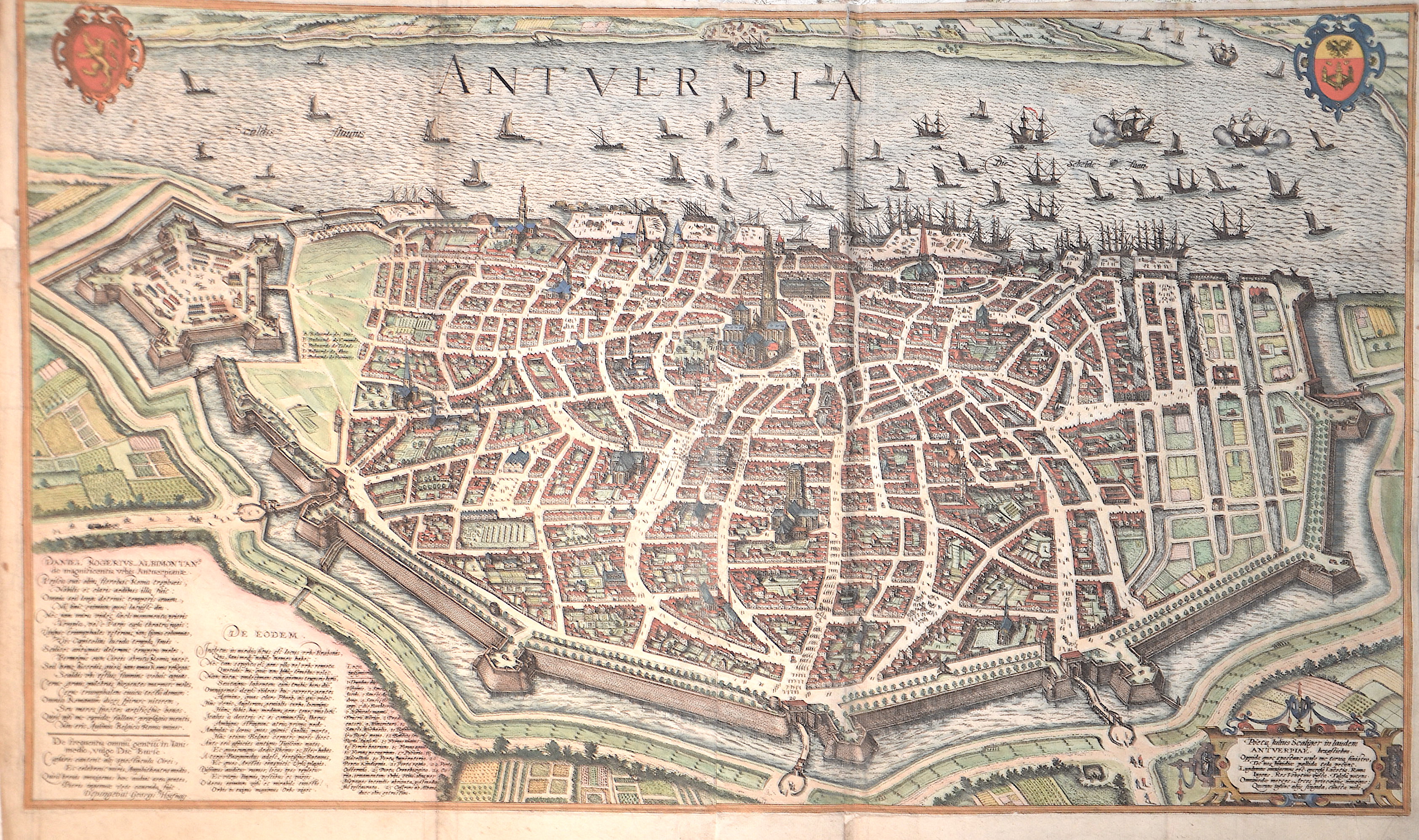
Antverpia / Pöeta Julius Scaliger in laudem Antwerpiae.

| Article ID | EUB1398 |
Title | Antverpia / Pöeta Julius Scaliger in laudem Antwerpiae. |
Description | Magnificent map shows a bird's eye view of the detailed city plan of Antwerp with index, two coats of arms, a title cartouche and many staffages. Rare |
| Year | ca. 1598 |
Artist | Braun/Hogenberg (1572-1618) |
Frans Hogenberg (1535 – 1590) was a Flemish and German painter, engraver, and mapmaker. Hogenberg was born in Mechelen as the son of Nicolaas Hogenberg In 1568 he was banned from Antwerp by the Duke of Alva. He travelled to London, where he stayed a few years before emigrating to Cologne. He is known for portraits and topographical views as well as historical allegories. He also produced scenes of contemporary historical events. George Braun (1541-1622), a cleric of Cologne, was the principal editor of the "Civitates Orbis Terrarum". The first volume of the Civitates Orbis Terrarum was published in Cologne in 1572. The sixth and the final volume appeared in 1617. This great city atlas, edited by Georg Braun and largely engraved by Franz Hogenberg, eventually contained 546 prospects, bird-eye views and map views of cities from all over the world. Braun (1541-1622), a cleric of Cologne, was the principal editor of the work, and was greatly assisted in his project by the close, and continued interest of Abraham Ortelius, whose Theatrum Orbis Terrarum of 1570 was, as a systematic and comprehensive collection of maps of uniform style, the first true atlas. | |
Historical Description | Antwerp a port city in the Belgian region of Flanders and the capital of the province of Antwerp. The city was first mentioned in documents in 726. After the division of the Frankish Empire, which began in 843, and other, mostly warlike, divisions of the Middle Kingdom, Antwerp became part of the Eastern Frankish Empire, the early medieval forerunner of the Holy Roman Empire, and received city rights in 1291. The city experienced its first heyday in the 14th century. Thanks to its port and cloth trade, it was a leading trading center and financial center in Europe. Antwerp fell to Burgundy in 1430 and to Habsburg in 1477. Antwerp was the end point of an important medieval long-distance trade route, the Brabanter Straße. It was a trade fair route that ran from Leipzig via Erfurt, Marburg, Siegen, Cologne, Aachen and Liège to Antwerp. A large part of the former East-West trade in furs, hardware and cloth was carried out through them. In the 15th and 16th centuries, Antwerp was one of the largest cities in the world, at times the most important trading metropolis in Europe and an important cultural center where artists such as Peter Paul Rubens worked. |
| Place of Publication | Cologne |
| Dimensions (cm) | 45 x 78 cm |
| Condition | Some folds perfectly restored |
| Coloring | original colored |
| Technique | Copper print |