

Adina Sommer
Antique and Contemporary Art
Winzerer Str. 154
80797 München
telephone
+49 89 304714
business hours:
by appointment
Email
![]()


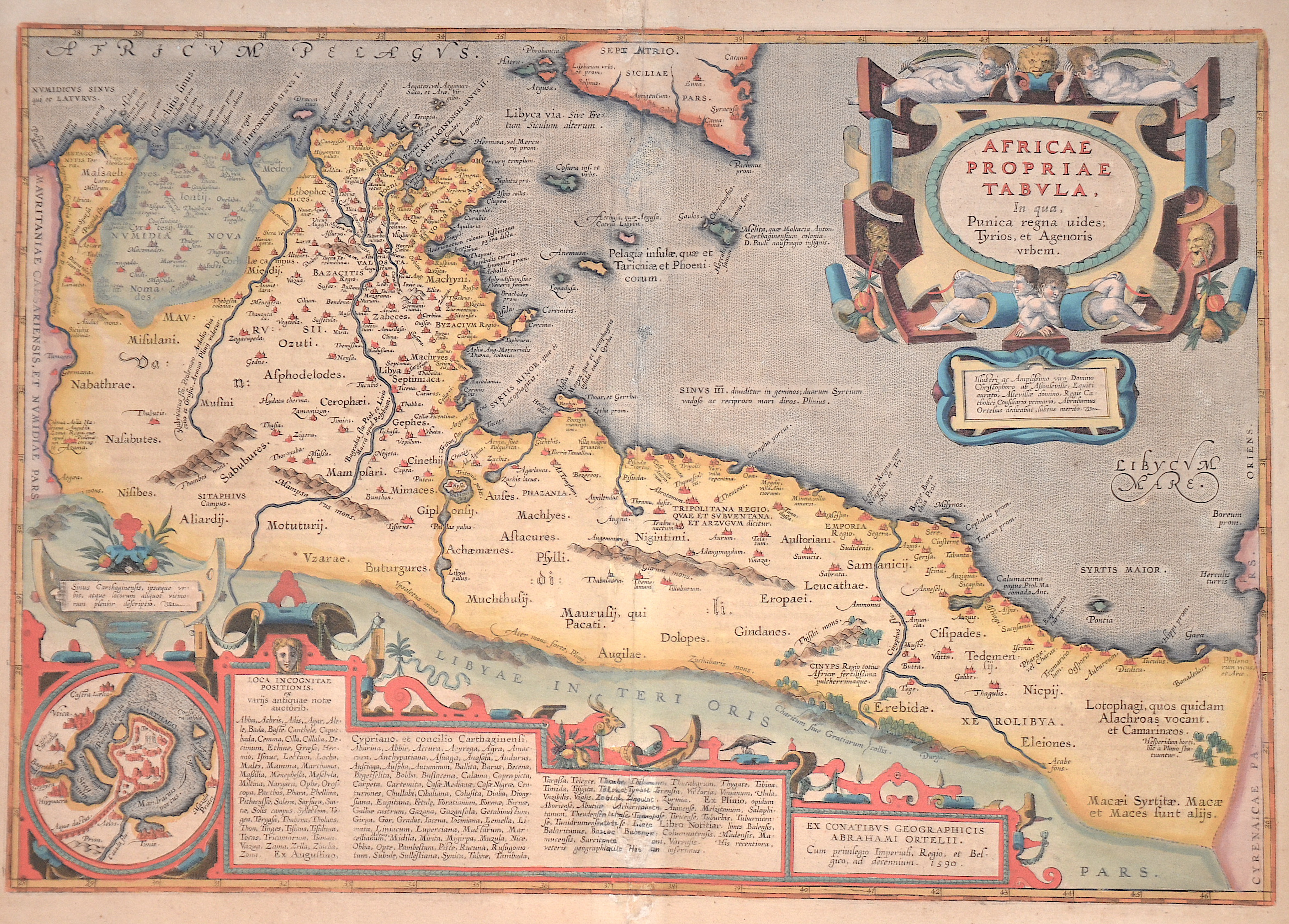
Africae Propriae Tabula, In qua, Punica regna uides, Tyrios, et Agenoris urbem.

| Article ID | AF0650 |
Title | Africae Propriae Tabula, In qua, Punica regna uides, Tyrios, et Agenoris urbem. |
Description | Map shows the northern coast of Africa between present-day Algeria (Mauritaniae Caesariensis) and Libya (Libyae Interioris pars). The Carthaginian Empire (today's Tunisia and Libya) is at the centre of the map. The islands of Sicily and Malta are also depicted. This map is based on Gastaldi's famous eight-sheet map of Africa. At the top right is a title cartouche below which is a text dedicating the map to the honourable and illustrious Lord Christophorus of Assonleville. Lord Christophorus was the ruler of Altevilla as well as a knight, diplomat and advisor to King Philip II. This is one of two Ortelius maps dedicated to him. Also below is a partial map of Carthage and an index surrounded by a magnificent scrollwork cartouche. Reverse in Latin, page III. |
| Year | ca. 1601 |
Artist | Ortelius (1527-1598) |
Abraham Ortelius (1527–1598) was a Flemish cartographer and publisher from Antwerp. Originally a map colorist, he became a major figure in cartography through his Theatrum Orbis Terrarum (1570), considered the first modern atlas—a uniform collection of reliable maps in book form. Influenced by Gerardus Mercator, Ortelius published several maps before compiling the Theatrum, which clearly showed America as a separate continent. The work was published in 42 editions and 7 languages by 1612. Unlike many of his peers, Ortelius cited his sources, and his atlas became a milestone in mapmaking and geographic knowledge. | |
Historical Description | Today's Tunisia experienced the establishment of commercial branches by settlers from the eastern Mediterranean at the beginning of the historical records. According to legend, it was Queen Élyssa, sister of the king of Tyr, Pygmalion, who founded the city. Carthage became the greatest power of the western Mediterranean in 150 years. The influence came partly through colonization, but mostly through commercial branches and contracts. This power and the high agricultural potential of the Carthaginian motherland led to the awakening of the interest of the young, strengthening Roman Empire and a confrontation that culminated in the three Punic Wars. Carthage, with its troops led by Hannibal, was able to bring the Roman Empire to the brink of defeat several times during the Second Punic War (218–201 BC). At the end of the Third Punic War (149-146 BC) the city of Carthage was besieged for three years and ultimately destroyed. The area of today's Tunisia became part of the Roman province of Africa with capital Utica. Africa, along with Egypt, became one of the most important suppliers of agricultural products in Rome. Above all, Africa supplied grain and olive oil. Christianity spread quickly, especially through the arrival of settlers, traders and soldiers. Carthage became known in this regard that the influential Christian apologist Tertullian lived and worked here, so that North Africa soon developed into one of several centers of Christianity. The first Arab advances into what is now Tunisia began in 647. Unlike previous conquerors, the Arabs were not satisfied with just occupying the coastal areas, but also set out to conquer the interior. From the first third of the 12th century, Tunisia was subjected to frequent attacks by the Normans from Sicily and southern Italy. The economic boom caused the Almohadic century to go down in history as the golden age of the Maghreb, when large cities developed with magnificent mosques and scientists like Ibn Chaldūn worked. From the second half of the 14th century, the Hafsids slowly lost control of their territory and came under the influence of the Merinids of Abu Inan Faris, especially after the lost Battle of Kairouan (1348). In 1705 Husain I. ibn Ali made himself a Bey of Tunis and founded the Husainid dynasty. Tunisia achieved a high degree of independence among the Husainids, although it was still officially an Ottoman province. Ahmad I. al-Husain, who ruled from 1837 to 1855, initiated a modernization push with important reforms such as the abolition of slavery or the adoption of a constitution. |
| Place of Publication | Antwerp |
| Dimensions (cm) | 33,5 x 48,5 cm |
| Condition | Some restoration at centerfold |
| Coloring | colored |
| Technique | Copper print |