

Adina Sommer
Antique and Contemporary Art
Winzerer Str. 154
80797 München
telephone
+49 89 304714
business hours:
by appointment
Email
![]()


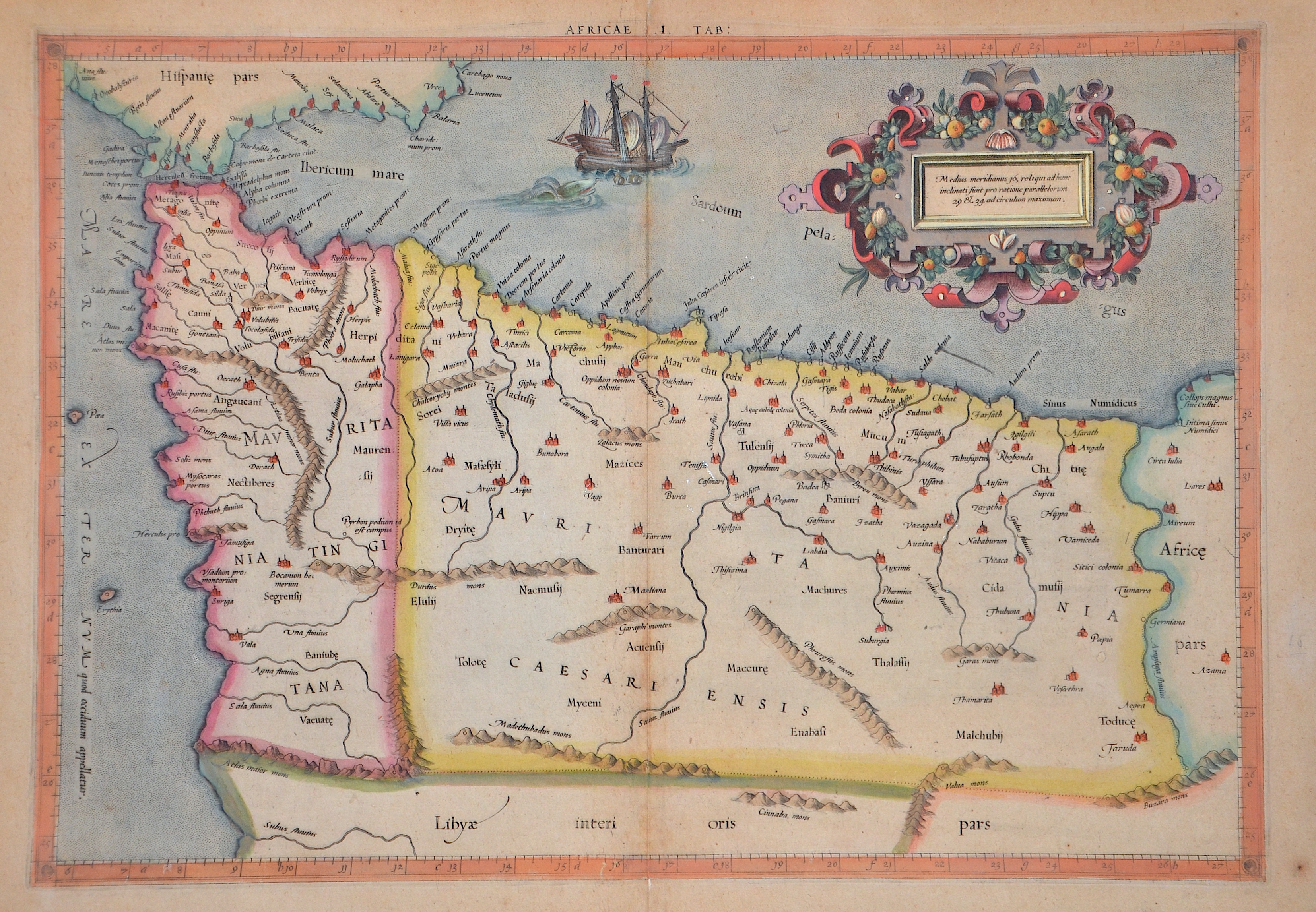
Africae I. Tab / Medius meridianus 16,..

| Article ID | AF0654 |
Title | Africae I. Tab / Medius meridianus 16,.. |
Description | Map shows Morocco, Algeria, Mauritania, a title cartouche and a sea monster next to a sailing ship. |
| Year | ca. 1690 |
Artist | Ptolemy/ Gerhard Mercator (1512-1594) |
Gerardus Mercator (1512 - 1594) He was a cartographer, philosopher and mathematician. He is best known for his work in cartography, in particular the world map of 1569 based on a new projection which represented sailing courses of constant bearing as straight lines. He is renowned to the present day as the cartographer who created a world map based on a new projection which represented sailing courses of constant bearing as straight lines. In his own day he was the world's most famous geographer but in addition he had interests in theology, philosophy, history, mathematics and magnetism as well as being an accomplished engraver, calligrapher and maker of globes and scientific instruments. He wrote few books but much of his knowledge is to be found in the copious legends on his wall maps and the prefaces that he composed for his atlas ,the first in which the term ""atlas"" appears and the sections within it." Claudius Ptolemy ( arround 100- 160 a.C.) Geographia, gives a list of geographic coordinates of spherical longitude and latitude of almost ten thousand point locations on the earth surface, as they were known at his times. The list is organized in Tabulae which cor- respond to specific regions of the three known continents at that time, Africa, Asia and Europe. Research on Ptolemy’s Geographia has started at the University of Thessaloniki, Greece, in the eighties, focused mainly, but not exclusively, on data re- lated to territories which are now under the sovereignty of the modern Greek state. The World of Ptolemy is classified in Regions, since each Chapter is referred to one of them, giving by this way the concept of Atlas as it is understood today. | |
Historical Description | North Africa in the broader geographical sense is the area of the continent of Africa that includes the Sahara and the coastal strip to the north, west and east of the Mediterranean, the Atlantic and the Red Sea. Religiously, North Africa is mainly characterized by Islam, ethnically by Berbers, Moors and Arabs, in the southernmost area also Nubians, Amhars and Black Africans. The core states of North Africa include Morocco with the Western Sahara, Algeria, Tunisia (small Maghreb), Libya (Greater Maghreb), Egypt and Sudan. Especially during the ongoing desert phase, contacts between North and sub-Saharan Africa were therefore limited almost exclusively to trade along the east and west coasts of the continent and to certain routes where there were sufficient water points, due to the difficulties of crossing the world's largest sandy desert. At the same time, this meant ethnic separation, and although North African culture has both African and Middle Eastern roots, with the Berbers possibly even European. With antiquity in the narrower sense, the interests of the Mediterranean peoples, which had previously been focused primarily on Egypt and the Near East in terms of power politics, gradually changed. As so often in history, it was trade that paved new paths; and the first people to devote themselves entirely to Mediterranean trade, even to the neglect of their own state structures, were the Phoenicians, but the place in North Africa where territorial state structures did develop, at least to some extent, was Carthage. In the period between the destruction of Carthage and Rome taking control of the Maghreb, there was a brief flourishing of local kingdoms. Two largely sedentary ethnic groups, the Moors and Numidians, were of particular importance. After the victory over Carthage, Roman culture and, above all, Roman administration spread relatively quickly from east to west along the Atlas mountain ranges across the new territories in North Africa. The North African provinces quickly became economically central to the Roman Empire, and between the 1st and 4th centuries AD, Rome's survival actually depended on grain and olive supplies from there, as the climate in North Africa at that time was wetter than it is today. When the Romans took power in the Mediterranean, a development came to an end in the course of which North Africa in particular finally became part of the Mediterranean world. |
| Place of Publication | Amsterdam |
| Dimensions (cm) | 33 x 46,5 cm |
| Condition | Some minor restoration at upper centerfold |
| Coloring | original colored |
| Technique | Copper print |