

Adina Sommer
Antique and Contemporary Art
Winzerer Str. 154
80797 München
telephone
+49 89 304714
business hours:
by appointment
Email
![]()


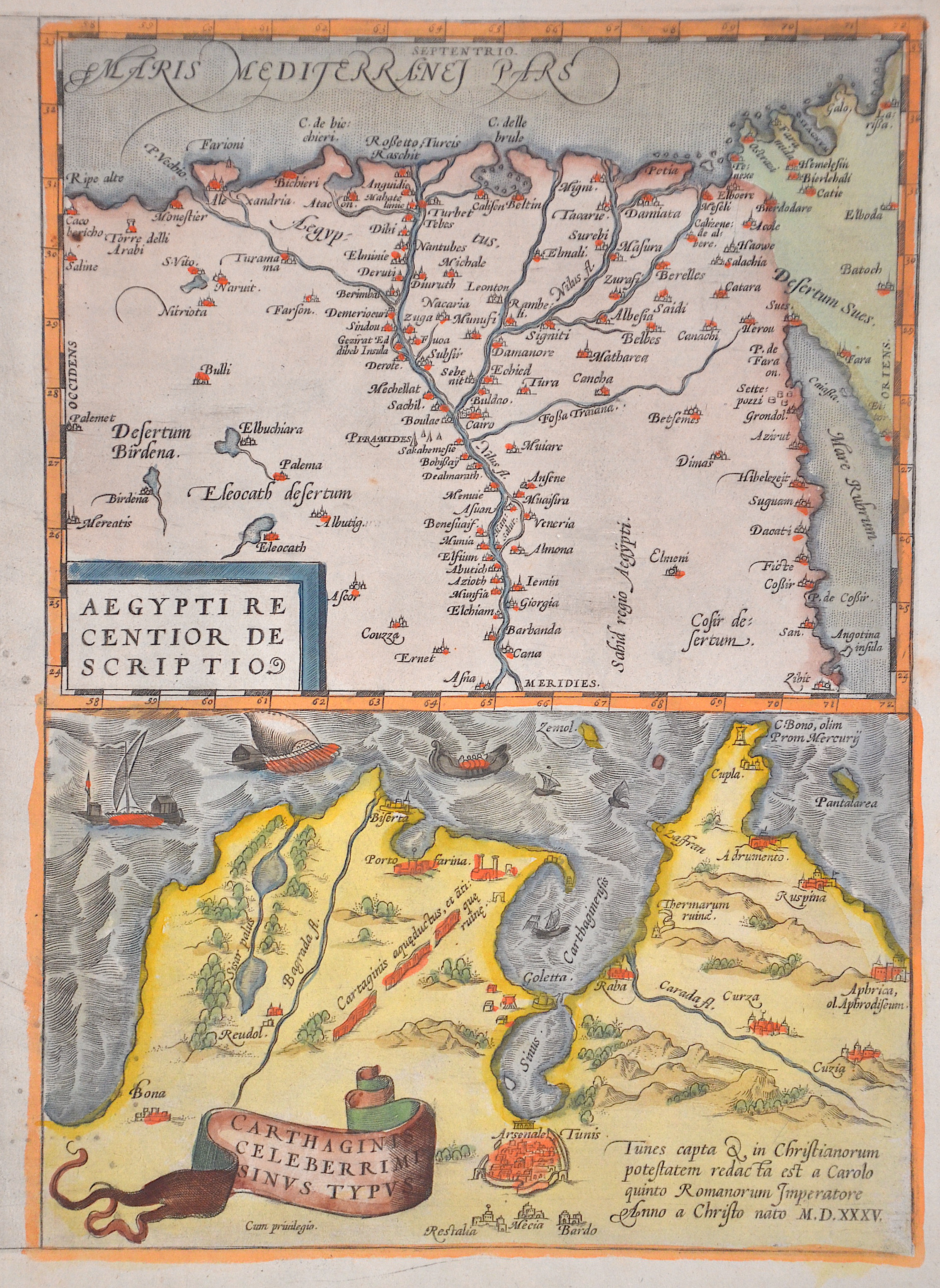
Aegypti recentior descriptio/ Carthaginis celeberrini sinus typus

| Article ID | AF079 |
Title | Aegypti recentior descriptio/ Carthaginis celeberrini sinus typus |
Description | Map shows Egypt and the bay of Tunis in Tunesia |
| Year | ca. 1630 |
Artist | Ortelius (1527-1598) |
Abraham Ortelius (1527–1598) was a Flemish cartographer and publisher from Antwerp. Originally a map colorist, he became a major figure in cartography through his Theatrum Orbis Terrarum (1570), considered the first modern atlas—a uniform collection of reliable maps in book form. Influenced by Gerardus Mercator, Ortelius published several maps before compiling the Theatrum, which clearly showed America as a separate continent. The work was published in 42 editions and 7 languages by 1612. Unlike many of his peers, Ortelius cited his sources, and his atlas became a milestone in mapmaking and geographic knowledge. | |
Historical Description | Egypt: The ancient Egyptian country name Kemet means "Black Land" and refers to the fertile soil of the Nile Valley in contrast to the "Red Land" of the neighboring deserts. The European terms Egypt, engl. Egypt comes from the Latin Aegyptus and thus ultimately from the ancient Greek Aigypto. The Copts claim to be the direct descendants of the ancient Egyptian pharaohs. From their name came the Greek Aigyptos, which became Egypt in German. Islamic Arabs conquered the Nile valley around 640; From now on Egypt was dominated by changing power centers - Damascus, Baghdad, Cairo. Under the Umayyads (661–750), Arab tribes settled in the fertile plains and from then on determined the cultural appearance of Egypt. With the coming to power of Saladin, the founder of the Ayyubid dynasty (1171–1249), Cairo became the center of Muslim resistance to the Christian crusades. Around 1250 the palace guard, which was made up of Mamluks, originally mostly Turkish military slaves, rose and took over. At the end of the 13th century, the Mamluks destroyed the last Crusader states on Asian soil. Even after Egypt was conquered by the Ottoman Empire in 1517, administration remained in their hands. The economic decline resulting from the discovery of the sea route to India (1498) made Egypt one of the poorest provinces of the Ottoman Empire. It was not until the landing of the French expeditionary force under Napoleon Bonaparte in 1798 that the Ottoman rule ended. When the French had to abandon their Oriental campaign after the British Admiral Nelson won at Abukir in the same year, the Albanian officer Muhammad Ali Pasha used the situation to seize power (1805–1849). He and his successors were able to achieve a certain independence under Ottoman rule, pursued an expansionary policy and initiated the history of modern Egypt. |
| Place of Publication | Antwerp |
| Dimensions (cm) | 32 x 23 |
| Condition | Very good |
| Coloring | original colored |
| Technique | Copper print |