

Adina Sommer
Antique and Contemporary Art
Winzerer Str. 154
80797 München
telephone
+49 89 304714
business hours:
by appointment
Email
![]()


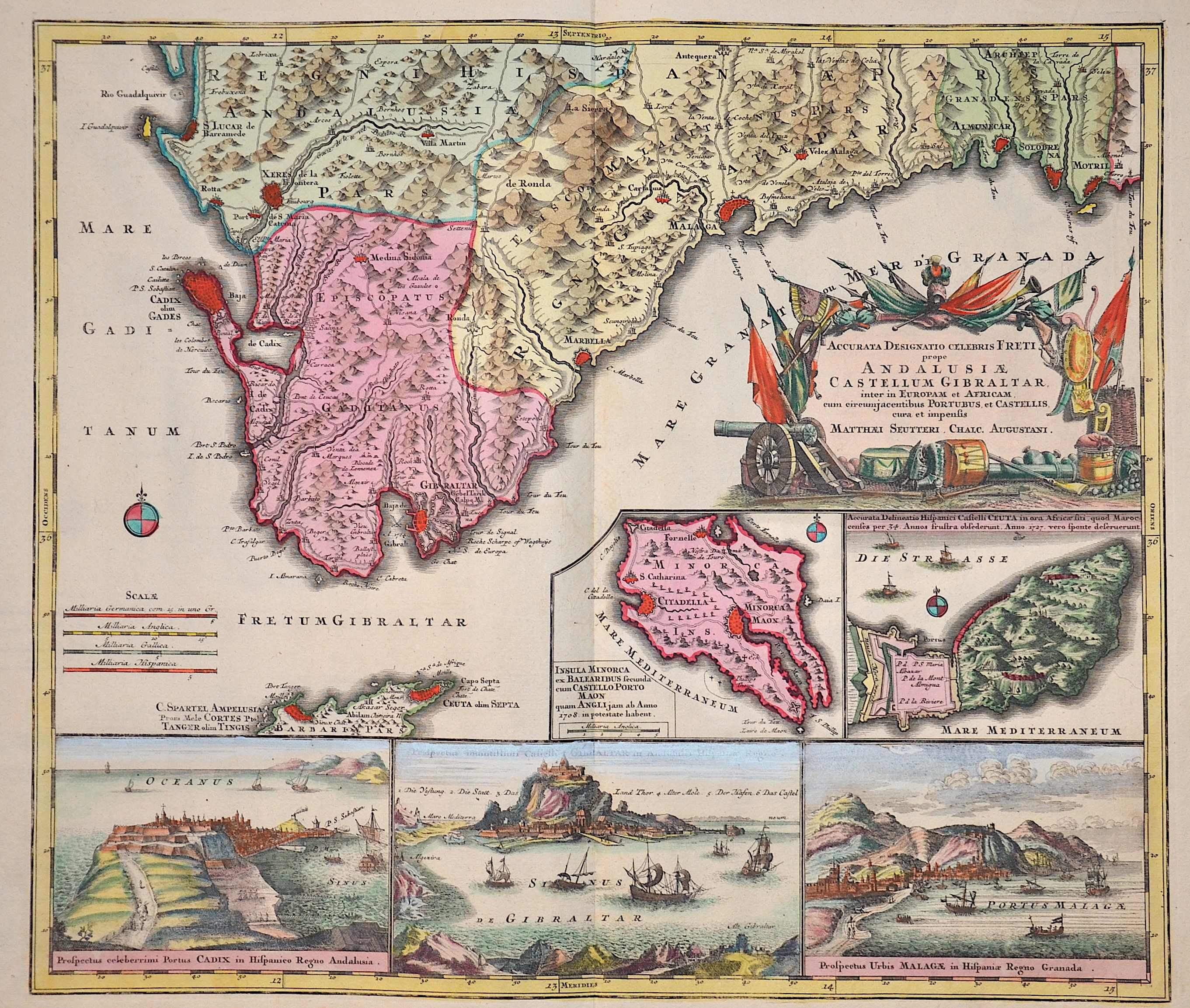
Accurata Designatio Celebris freti prope Andalusiae Castellum Gibraltar, inter in Europam et Africam…

| Article ID | EUE943 |
Title | Accurata Designatio Celebris freti prope Andalusiae Castellum Gibraltar, inter in Europam et Africam… |
Description | Map shows Andalusia with Gibraltar and Views of the cities of Cadix, Castelli di Gibraltar and Malaga, seperate maps of Minorca and the spanish Ceuta in Marokko. |
| Year | ca. 1730 |
Artist | Seutter (1678-1757) |
Matthias Seutter (1678- 1757) Augsburg was the son of a goldsmith in Augsburg. In 1697, Seutter began his studies in Nuremberg and subsequently worked in the publishing house of Jeremias Wolff in Augsburg. In 1710, he established his own publishing house and print shop. The Seutter publishing house produced a great number of maps, atlases, and globes. However, very few original maps were printed there, as Augsburg at that time had no university and no connection to the fields of mathematics or the natural sciences. Seutter therefore copied the work of other cartographers, making his own engravings based on their models. Over 500 maps were produced in his studio. Seutter's most well-known works are the 1725 "Geographical Atlas or an Accurate Depiction of the Whole World" ("Atlas Geographicus oder Accurate Vorstellung der ganzen Welt") with 46 maps, the 1734 "Large Atlas" ("Grosser Atlas") with 131 maps, and the 1744 pocket atlas "Small Atlas" ("Atlas minor") with 64 maps. Matthäus Seutter died in 1757. Seutter's son Albrecht Karl, his son-in-law Conrad Tobias Lotter, and his business partner Johann Michael Probst ran the printing business for five more years. | |
Historical Description | From the beginning of the 9th century BC at the latest, the Phoenicians sailed as far as the Andalusian coast, even beyond the Strait of Gibraltar, and traded with the local population. After Phoenician activities were apparently initially limited to trade and the establishment of trading posts in indigenous coastal settlements, they founded their own settlements from the 8th century BC. At the time of Roman rule in Hispania, the Andalusians quickly learned the Latin language and got along quite well with the Roman legionaries. In late antiquity, when the Western Roman Empire was showing signs of dissolution, Vandals and other Germanic tribes invaded Hispania at the beginning of the 5th century. After the middle of the 5th century, the Visigoths conquered Hispania and established their own empire with Toledo as its capital. In the 6th century, parts of Andalusia were occupied by the Eastern Romans, who, however, had to withdraw at the beginning of the 7th century. In 711 the Moors crossed the straits and within a few years conquered most of the Visigoth Empire. Of all the Spanish regions, Andalusia was under Islamic rule the longest. It reached its zenith under the Emirate of Córdoba, the Caliphate of Córdoba, and the Nasrids in the Emirate of Granada. The influences of the Muslims can be seen above all in the architecture, including the Alhambra in Granada, the Mezquita of Córdoba and the Giralda in Seville. The rule of the Moors in Spain was ended by the Reconquista (1492) in Granada. Despite all the guarantees of religious freedom granted in the Treaty of Granada (1491), the forced conversion of the Mudejares by the Catholic Church and the expropriation of Muslim religious institutions soon began (formally in 1502). The city of Seville became the maritime trade center of Spain in the 16th and 17th centuries. During this period, the port of Seville held the monopoly over overseas trade. Amerigo Vespucci and Ferdinand Magellan planned and launched their voyages of discovery here. |
| Place of Publication | Augsburg |
| Dimensions (cm) | 49 x 57 cm |
| Condition | Perfect condition |
| Coloring | original colored |
| Technique | Copper print |