

Adina Sommer
Antique and Contemporary Art
Winzerer Str. 154
80797 München
telephone
+49 89 304714
business hours:
by appointment
Email
![]()


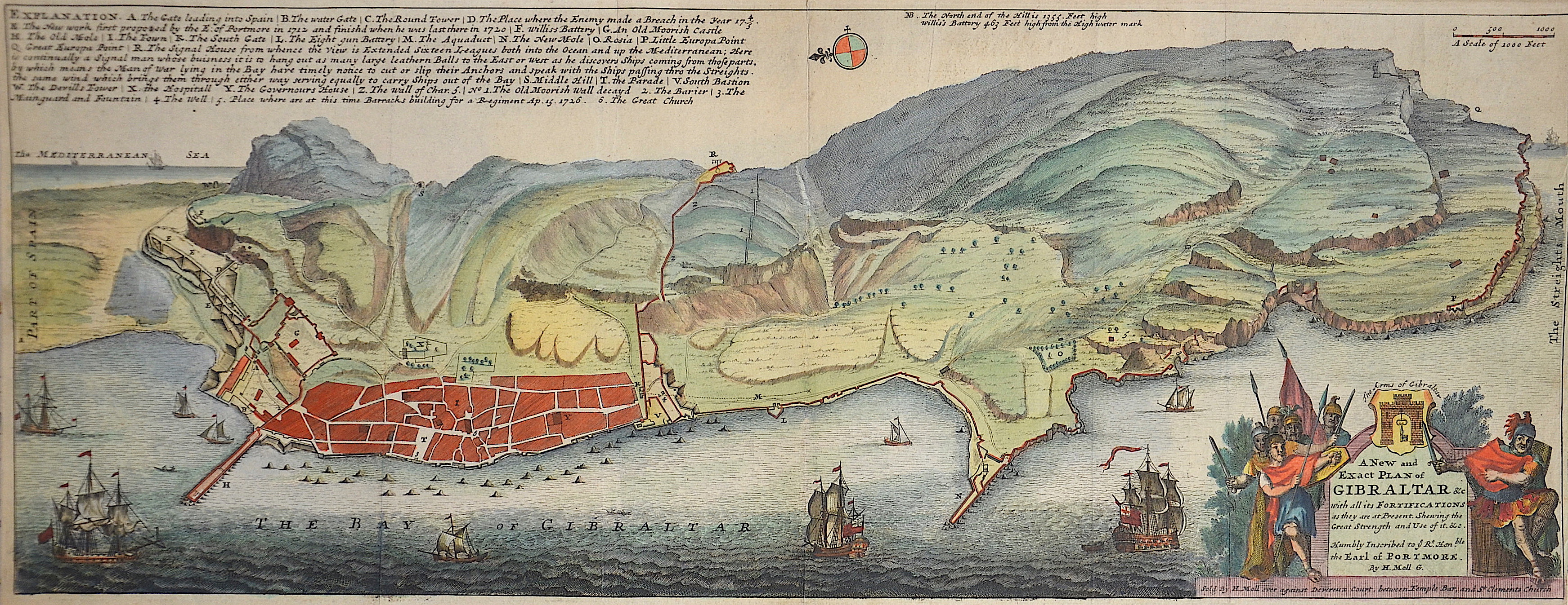
A New and Exact plan of Gibraltar with all its fortifications as they are at present….

| Article ID | EUE1675 |
Title | A New and Exact plan of Gibraltar with all its fortifications as they are at present…. |
Description | Map shows a city map city of Gibraltar, with beautiful cartouche. |
| Year | ca. 1711 |
Artist | Moll (1654-1732) |
Hermann Moll (1654–1732) was a London-based engraver, cartographer, and publisher known for his detailed maps of Europe and the Americas. He also created maps for Defoe’s Robinson Crusoe and Swift’s Gulliver’s Travels. His major works include the Atlas Geographus (1711–1717) and Atlas Minor (1719), both published in multiple editions. Moll collaborated with explorer William Dampier, whose travel reports provided valuable geographic data for Moll’s maps. Dampier’s popularity and the public’s growing interest in travel literature helped boost Moll’s success, leading other authors like Defoe and Swift to use his illustrations. | |
Historical Description | Gibraltar is a British Overseas Territory located on the southern end of the Iberian Peninsula. In 1704, during the War of the Spanish Succession, a combined Anglo-Dutch fleet, representing the Grand Alliance, captured the town of Gibraltar on behalf of the Archduke Charles of Austria in his campaign to become King of Spain. The occupation of the town by Alliance forces caused the exodus of the population to the surrounding area of the Campo de Gibraltar.As the Alliance's campaign faltered, the 1713 Treaty of Utrecht was negotiated and ceded control of Gibraltar to Britain to secure Britain's withdrawal from the war. Unsuccessful attempts by Spanish monarchs to regain Gibraltar were made with the siege of 1727 and again with the Great Siege of Gibraltar (1779 to 1783), during the American War of Independence. Gibraltar became a key base for the Royal Navy and played an important role prior to the Battle of Trafalgar. |
| Place of Publication | London |
| Dimensions (cm) | 23 x 60,5 |
| Condition | Very good |
| Coloring | original colored |
| Technique | Copper print |