

Adina Sommer
Antique and Contemporary Art
Winzerer Str. 154
80797 München
telephone
+49 89 304714
business hours:
by appointment
Email
![]()


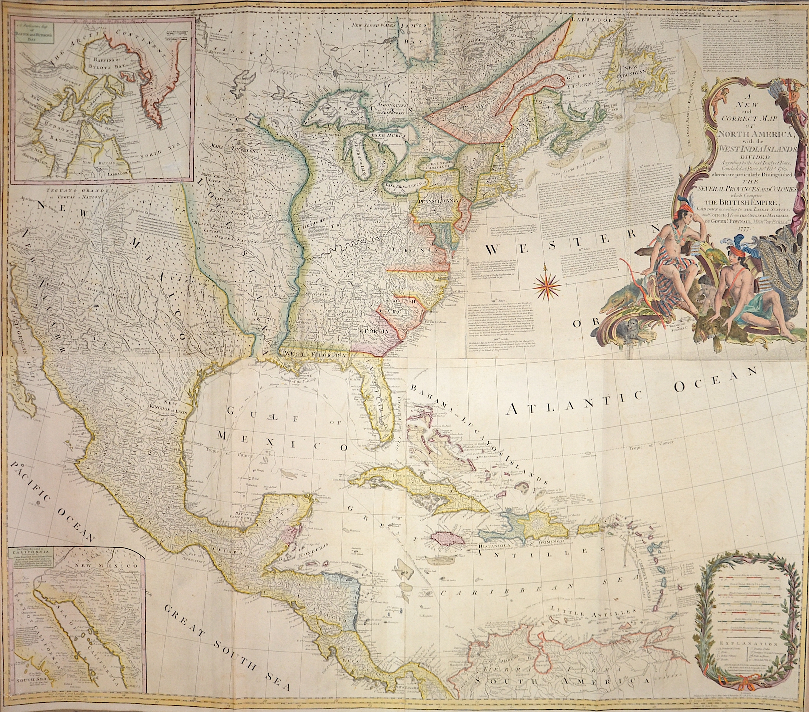
A New and Correct Map of North America, with the West India Islands.

| Article ID | AMU1497 |
Title | A New and Correct Map of North America, with the West India Islands. |
Description | Map shows the entire USA, Central America, the Caribbean, partly Canada and two partial maps "A particular map of Baffin and Hudson's Bay" and "The passage by land to California". Furthermore a magnificent title cartouche and a cartouche around the mileage indicator.This map was originally published in 1755 and underwent numerous additions and changes until 1798, based on Governor Pownall's surveys. This edition reflects the political boundaries established by the Treaty of Versailles of 1783 (or Peace of Paris), which most notably ended the American Revolutionary War. In the upper right corner is Article III of the Treaty, which established the fishing arrangements between the British and Americans in Canada. |
| Year | c. 1786 |
Artist | Pownall (1722-1805) |
Thomas Pownall (1722 – 1805) was a British politician and colonial official. He was governor of the Province of Massachusetts Bay from 1757 to 1760, and afterward served in the British Parliament. He travelled widely in the North American colonies prior to the American Revolutionary War, opposed Parliamentary attempts to tax the colonies, and was a minority advocate of colonial positions until the Revolution. Classically educated and well-connected to the colonial administration in London, Pownall first travelled to North America in 1753, and spent two years exploring the colonies before being appointed Lieutenant Governor of New Jersey in 1755. He became governor of Massachusetts in 1757 after helping engineer the recall of longtime Governor William Shirley. His administration was dominated by the French and Indian War, in which Pownall was instrumental in raising Massachusetts provincial militia for the war effort. He opposed military interference in colonial administration, including attempts to quarter British troops in private homes, and had a generally positive relationship with the colonial assembly. Returning to England in 1760, he continued to be interested in colonial affairs, publishing widely read materials on conditions in the colonies, including several editions of The Administration of the Colonies. As a Member of Parliament he regularly advocated for colonial positions without much success, but supported the war effort once the Revolutionary War began. In the early 19th century he became an early advocate of the reduction or removal of trade barriers, and the establishment of a solid relationship between Britain and the United States. Several writers have proposed that Pownall was Junius, a pseudonymous writer of letters critical of British governmental practices. | |
Historical Description | The first European settlement in what is now U.S. territory was established by the Spanish at St. Augustine in Florida in 1565. The first permanent English colony was Jamestown in Virginia, which came into existence in 1607, shortly after Frenchmen established a first colony in what later became Canada. The arrival of the emigrant ship "Mayflower" at Plymouth Colony in 1620 is considered an important symbolic date. Swedish colonies on the Delaware and Dutch settlements around New York (Nieuw Amsterdam) were taken over by England. Apart from the British, only the French and Spanish were able to achieve lasting political importance. For Spain, its colony of Florida had only a secondary function compared to its large possessions in Central and South America. France, on the other hand, limited its settlement to its core colonial territory on the St. Lawrence River (New France), while still retaining a strong economic interest in its remaining territories between the Mississippi River and the thirteen colonies of the British. To cover the fur trade routes, these territories, otherwise not settled by Europeans, were protected by a system of forts and alliances. The British colonies, on the other hand, were under high immigration pressure, which led to a constant westward shift of the settlement boundary. This occurred partly according to state plan (by a single colony) and partly in wild colonization against British and Indian resistance. The conflicting interests clashed in the French and Indian War of 1754 to 1763. The war was a sideshow in the global confrontation between Britain and France, the Seven Years War. Most Indian tribes fought on the side of the French. The British side was awarded all of the French territories east of the Mississippi River (except New Orleans) and the French-populated areas around Quebec and Montreal in the peace treaty of 1763. Spain had sided with its French kin during the war. After the war, it had to cede Florida to the British and received as compensation the previously French territory west of the Mississippi. The government in London demanded that the colonists bear a higher share of the costs of the postwar settlement. The colonies resisted taxation There were boycotts and acts of resistance, such as the Boston Tea Party, which found an initial climax in the Boston Massacre. London eventually stationed more soldiers, which further fueled secessionist tendencies in the thirteen colonies. In 1775, British soldiers sparked the War of Independence when they dug up a colonial arsenal. A Continental Congress convened, giving military supreme command to George Washington. On July 4, 1776, the thirteen colonies proclaimed the Declaration of Independence. |
| Place of Publication | London |
| Dimensions (cm) | 102 x 116 cm |
| Condition | Printed on 4 sheets joined together |
| Coloring | original colored |
| Technique | Copper print |