

Adina Sommer
Antique and Contemporary Art
Winzerer Str. 154
80797 München
telephone
+49 89 304714
business hours:
by appointment
Email
![]()


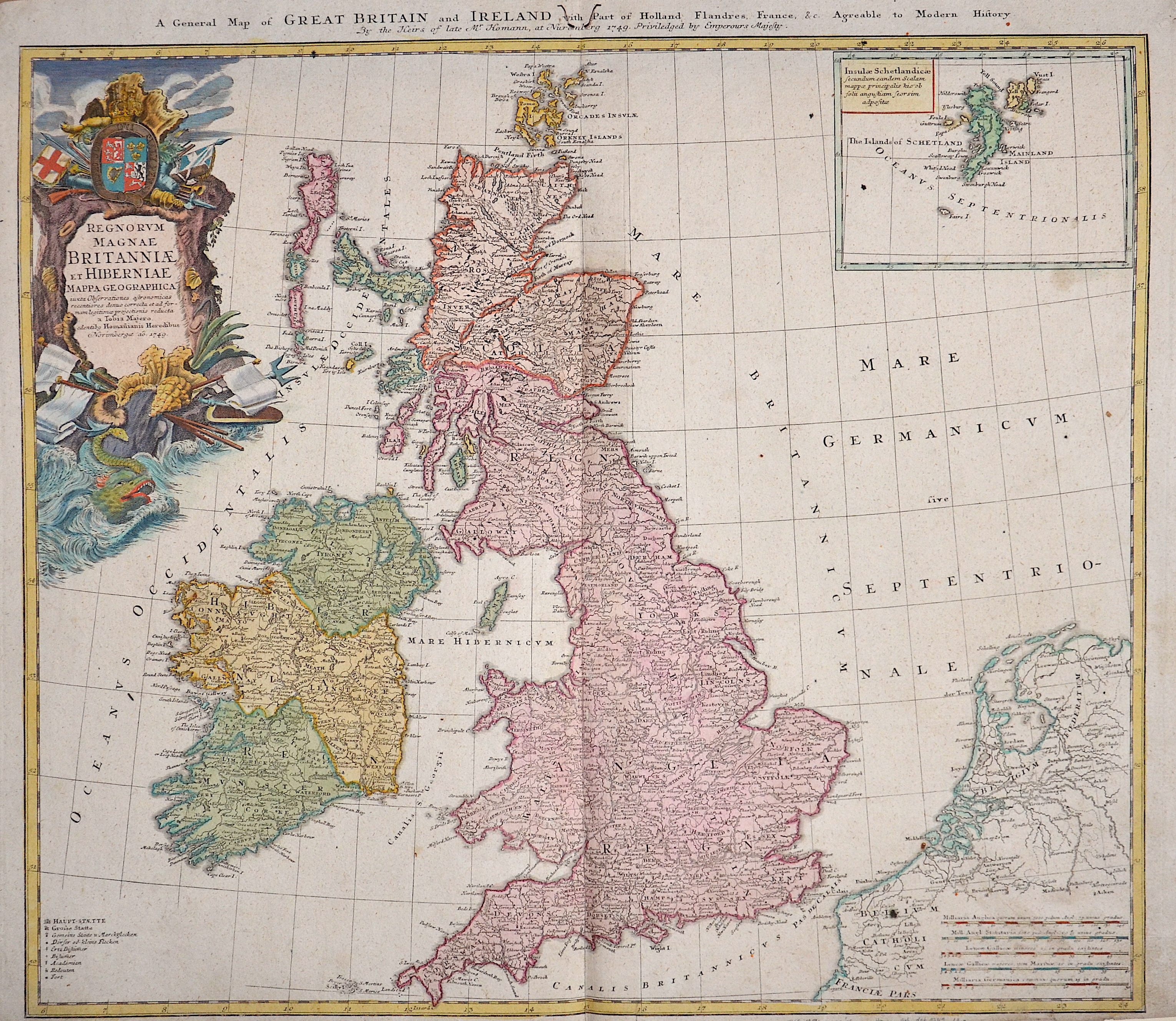
A general map of Great Britain and Ireland with part of Holland Flandres, France……

| Article ID | EUG1954 |
Title | A general map of Great Britain and Ireland with part of Holland Flandres, France…… |
Description | The map shows the whole of Great Britain with a partial map of the Shetland Islands and a title cartouche. |
| Year | dated 1749 |
Artist | Homann Erben (1724-1780) |
Johann Babtiste Homann (1664-1724) was born in Oberkammlach, the Electorate of Bavaria. Although educated at a Jesuit school, and preparing for an ecclesiastical career, he eventually converted to Protestantism and from 1687 worked as a civil law notary in Nuremberg. He soon turned to engraving and cartography; in 1702 he founded his own publishing house. Homann acquired renown as a leading German cartographer, and in 1715 was appointed Imperial Geographer by Emperor Charles VI. Giving such privileges to individuals was an added right that the Holy Roman Emperor enjoyed. In the same year he was also named a member of the Prussian Academy of Sciences in Berlin. Of particular significance to cartography were the imperial printing privileges (Latin: privilegia impressoria). These protected for a time the authors in all scientific fields such as printers, copper engravers, map makers and publishers. They were also very important as a recommendation for potential customers. In 1716 Homann published his masterpiece Grosser Atlas ueber die ganze Welt (Grand Atlas of all the World). Numerous maps were drawn up in cooperation with the engraver Christoph Weigel the Elder, who also published Siebmachers Wappenbuch. Homann died in Nuremberg. He was succeeded by the Homann heirs company, which was in business until 1848. The company was known as Homann Erben, Homanniani Heredes, or Heritiers de Homann abroad. | |
Historical Description | The Romans settled for the first time under the leadership of Caesar 55 and 54 BC. BC in England, but initially not as a conqueror. It was not until almost a century later that the Romans occupied England. Scottish ethnic groups repeatedly penetrated the power vacuum that emerged after the Roman withdrawal around 410 AD. Subsequently, groups of Anglers, Jutters and Saxons immigrated. This was the beginning of the early Middle Ages in Britain. The Danish Vikings finally sailed to England in the late 8th century. At first, they only carried out raids, but later they established themselves, asked for tribute payments and built their own villages. Wilhelm's victory in the High Middle Ages led to the introduction of the Normans' effective armrest system. A small Norman upper class almost completely replaced the established nobility. In the period from the middle of the 10th to the middle of the 14th century, the population tripled, and agriculture was intensified with the introduction of three-field farming and land reclamation. However, self-sufficiency with food only succeeded in climatically favorable and politically stable times. The Hundred Years War broke out in the late Middle Ages, the deposition of Richard II by later Henry IV and the failures in the Hundred Years War were the reasons for the outbreak of the subsequent Rose Wars. During the Tudor period, the Renaissance of England peaked through Italian courtiers who reintroduced the artistic, educational, and scientific debate from antiquity. England began to develop naval skills, and exploration of the West and Europe intensified. Henry VIII broke out of communion with the Catholic Church in connection with his divorce under the Acts of Supremacy of 1534, which proclaimed the monarch head of the Church of England. Unlike much of European Protestantism, the roots of the split were political rather than theological. There were internal religious conflicts during the reign of Henry's daughters Mary I and Elizabeth I. The former brought the country back to Catholicism, while the latter abandoned it and vigorously maintained the predominance of Anglicanism. The Elizabethan era began with Elizabeth I's accession to the throne in 1588. The new, Protestant queen was enthusiastically received by the people. From the beginning of her reign, a possible marriage of the queen was the dominant issue. Parliaments repeatedly asked them to obtain a male heir to the throne. She was responsible for the implementation of the Reformation, but also for the poorer relations with Spain. |
| Place of Publication | Nuremberg |
| Dimensions (cm) | 47,5 x 53,5 cm |
| Condition | Some restoration at lower centerfold |
| Coloring | colored |
| Technique | Copper print |