

Adina Sommer
Antique and Contemporary Art
Winzerer Str. 154
80797 München
telephone
+49 89 304714
business hours:
by appointment
Email
![]()


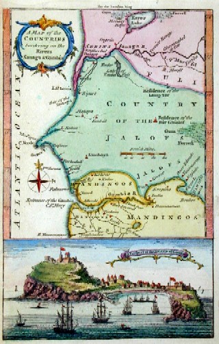
A map of the countries bordering on the Rivers Sanaga Gambia

| Article ID | AF0101 |
Title | A map of the countries bordering on the Rivers Sanaga Gambia |
Description | Map shows Senegal and Gambia with a view of the island of Gorée near Cap Verde. After Jacob van der Schley. |
| Year | ca. 1720 |
Artist | Bellin (1703-1772) |
Jacques-Nicolas Bellin (1703 Paris -1772 Versailles) was a French cartographer, engineer-geographer, marine hydrographer. As a contributor to the Encyclopédie, he wrote more than a thousand articles on maritime topics. As a cartographer, Bellin distinguished himself primarily in the field of sea cartography. From 1721 he worked for the Dépot des Cartes et Plans de la Marine, from 1741 until his death as an engineer-hydrograph of the Navy. In 1753 his atlas Neptune français, which covered all the coasts of France, was published, and in 1756 the hydrography françoise covering all seas of the earth. In 1764 the five-volume Petit Atlas maritime was published, which Bellin prepared on the orders of the Minister of the Navy, Choiseul. In addition, he wrote a number of geographical works and with Nouvelle méthode pour apprendre la geographie (1769) a geographic textbook for teaching. His maps illustrated, among other things, Bougainville's work Voyage autour du monde, published in 1771. As a co-author of the Encyclopédie edited by Diderot and d'Alembert, Bellin wrote more than a thousand articles in the field of shipping and navy. | |
Historical Description | In 1444, the first Portuguese ship reached the coast off what is now Senegal. The Portuguese were primarily interested in trading African gold, bypassing the Arabs. In the following centuries, the trade was carried on by lançados, descendants of Portuguese sailors and African women. Communities of Lançados existed in numerous places along the African coast; however, these were not initially colonies. Toward the end of the 15th century, a strong northern migration of Tukulor took place, finally destroying the state of Takrur and causing Jolof to break up into several kingdoms, namely Waalo, Cayor, Baol, Sine, and Saloum. These states were all unstable; nobles, kings, and members of the warrior caste of the old Mali Empire fought for influence. |
| Place of Publication | London |
| Dimensions (cm) | 18 x 11 cm |
| Condition | Very good |
| Coloring | colored |
| Technique | Copper print |