

Adina Sommer
Antique and Contemporary Art
Winzerer Str. 154
80797 München
telephone
+49 89 304714
business hours:
by appointment
Email
![]()


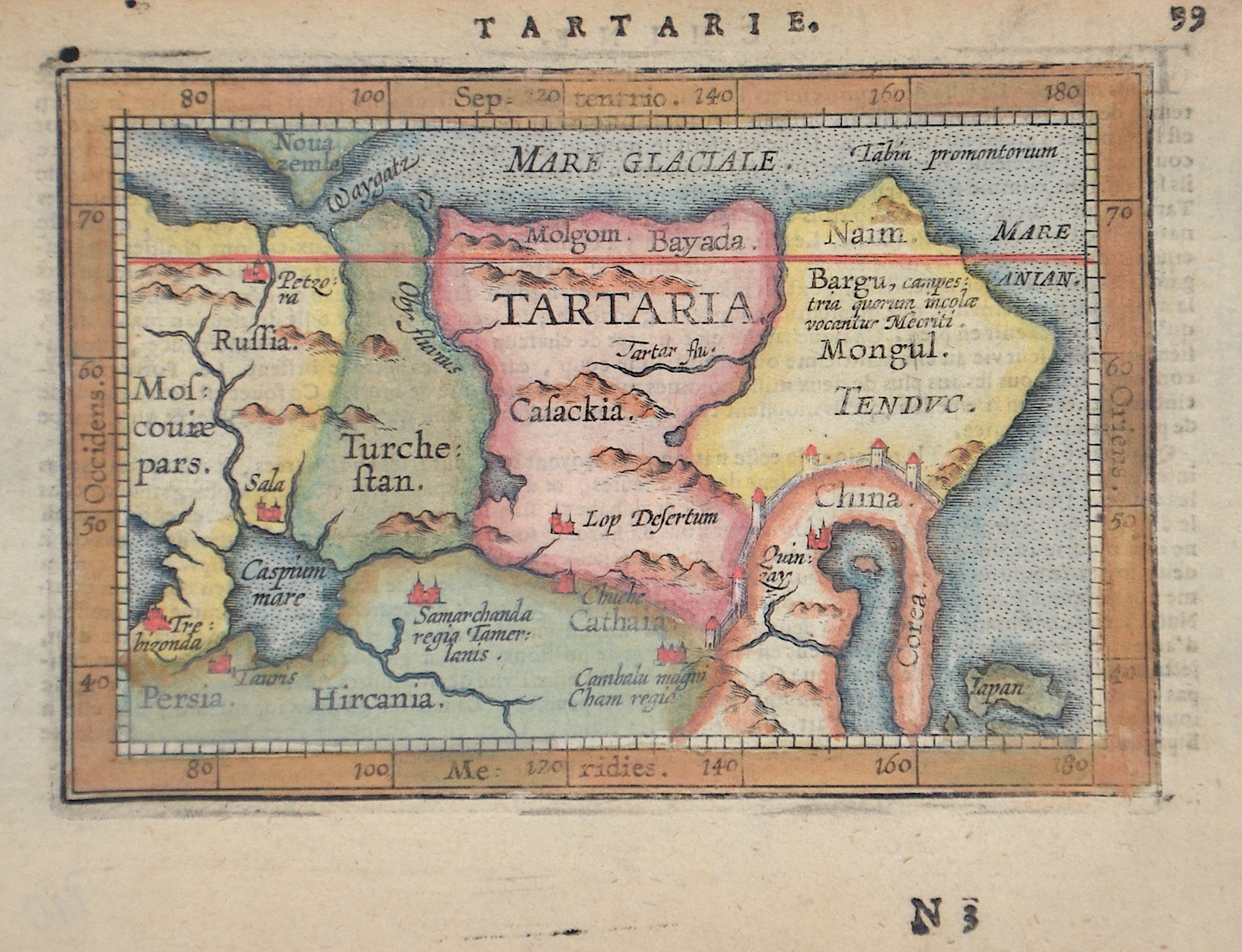
Tartarie. 99
| Article ID | EUO5301 |
Title | Tartarie. 99 |
Tartaria map shows all of Russia with its neighboring countries such as China, Korea, Japan, etc. From "Abraham Ortelius His epitome of the Theater of the Worlde." by Coignet Michel (1549-1623), cartographer Abraham Ortelius, printed by James Shawe, London. | |
| Year | ca. 1603 |
Artist | Ortelius (1527-1598) |
Abraham Ortelius (1527–1598) was a Flemish cartographer and publisher from Antwerp. Originally a map colorist, he became a major figure in cartography through his Theatrum Orbis Terrarum (1570), considered the first modern atlas—a uniform collection of reliable maps in book form. Influenced by Gerardus Mercator, Ortelius published several maps before compiling the Theatrum, which clearly showed America as a separate continent. The work was published in 42 editions and 7 languages by 1612. Unlike many of his peers, Ortelius cited his sources, and his atlas became a milestone in mapmaking and geographic knowledge. | |
Historical Description | Until the end of the 18th century, Tatarei was the name for a large region in Central Asia, Northern Asia and parts of Eastern Europe. This land was the homeland of the Tatars, as the Mongols and the Turkic peoples were generalized by Europeans. The territory of the Mongol Empire and its successor states covered large parts of the Tatarei.The historical name Tatarei were used by Europeans from the Middle Ages until the 19th century, but is no longer in use today. Tatarei gradually lost its importance as political and ethnic conditions changed with the expansion of the Russian Empire and Russian settlement, and the process of assimilation by the Russian Empire was completed with the dissolution of Free Tartarei in the early 19th century. |
| Place of Publication | London |
| Dimensions (cm) | 9 x 12 cm |
| Condition | Perfect condition |
| Coloring | original colored |
| Technique | Copper print |