

- Alsace
- Aquitaine
- Auvergne
- Bourgogne
- Bourgogne-Franche-Comte
- Brittany
- Centre
- Champagne
- Flandre
- France Islands
- Gascogne
- Gironde
- Hauts-de-France
- Ile de France
- Languedoc
- Lothringen
- Midi-Pyrénées
- Nivernais
- Nord-Pas-de-Calais
- Normandie
- Occitanie
- Pas-de-Calais
- Pays de la Loire
- Picardie
- Poitou-Charentes
- Provence-Alpes-Cote d Azur
- Pyrénées
- Rhone- Alpes
- Saintonge
- Savoyen
- Tourain
- Westcoast
Adina Sommer
Antique and Contemporary Art
Winzerer Str. 154
80797 München
telephone
+49 89 304714
business hours:
by appointment
Email
![]()


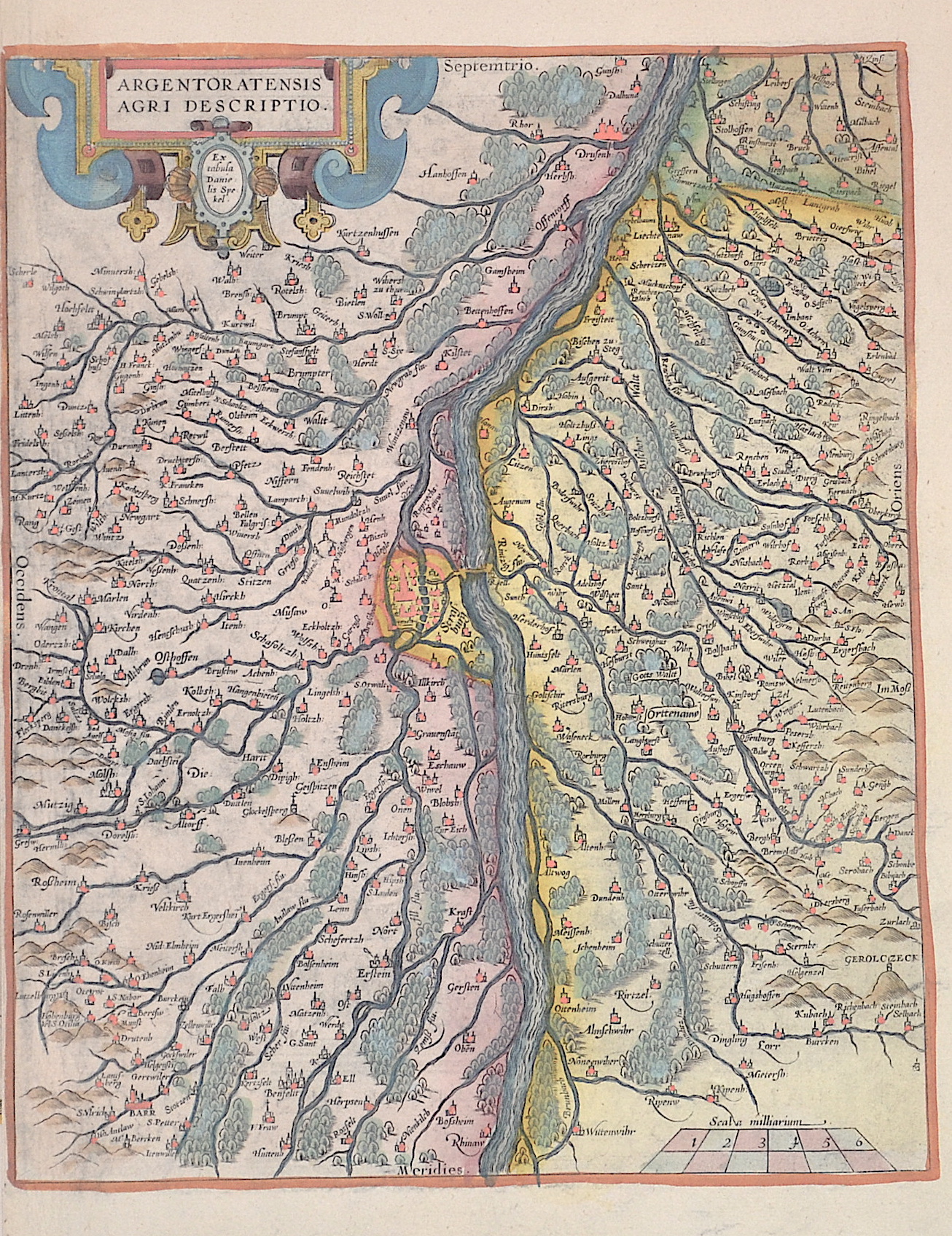
Argentoratensis agri descriptio.
| Article ID | EUF5147 |
Title | Argentoratensis agri descriptio. |
Map shows Strasbourg with the Rhine and the surrounding area with the towns of Barr, Benfeld, Osthoffen, Offendorf, Drusenheim, Offenburg, and many more. With a scroll title cartouche and a mileage indicator. The map is based on the 1576 map of Alsace by Daniel Specklin (Meurer pp. 243-244). | |
| Year | ca. 1590 |
Artist | Ortelius (1527-1598) |
Abraham Ortelius (1527–1598) was a Flemish cartographer and publisher from Antwerp. Originally a map colorist, he became a major figure in cartography through his Theatrum Orbis Terrarum (1570), considered the first modern atlas—a uniform collection of reliable maps in book form. Influenced by Gerardus Mercator, Ortelius published several maps before compiling the Theatrum, which clearly showed America as a separate continent. The work was published in 42 editions and 7 languages by 1612. Unlike many of his peers, Ortelius cited his sources, and his atlas became a milestone in mapmaking and geographic knowledge. | |
Historical Description | The history of Alsace, a region on the western edge of the German-speaking area, is shaped by the fruitful influence of two of Europe's great cultural areas: Germanic (German) and Romance (French). After the Great Migration, it was first Germanised and incorporated into the cultural currents of German history. Since modern times it has increasingly come under the political control of the French kingdom. Various forms emerged here, the Duchy of Alsace (7th – 8th centuries), the two landgravates of Alsace (12th – 17th centuries) and the early modern French province of Alsace (17th – 18th centuries). Today's Alsace was first settled by humans around 700,000 years ago and was one of the core regions of the Celts. After a period of unclear and changing power relations, Alsace became part of Alemannia until the 7th century, which was a more or less autonomous administrative district of the Franconian Empire. In 988 at the latest, Alsace became part of the Duchy of Swabia, with which it remained until the end of 1250. After 1250, a large number of different territories developed, most of which came under French rule between 1633 and 1697/1714. The French province of Alsace was established, its borders partially differing from those of the earlier landgravates. At the beginning of the French Revolution, all special political rights were abolished in 1789 and the two departments of Haut-Rhin and Bas-Rhin were created in 1790. Between 1871 and 1918, Alsace, as part of Alsace-Lorraine, belonged to the German Empire, which was led by Prussia. In 1918 the two Alsatian districts came back to France as departments. |
| Place of Publication | Antwerp |
| Dimensions (cm) | 30,5 x 25 cm |
| Condition | Perfect condition |
| Coloring | original colored |
| Technique | Copper print |