

Adina Sommer
Antique and Contemporary Art
Winzerer Str. 154
80797 München
telephone
+49 89 304714
business hours:
by appointment
Email
![]()


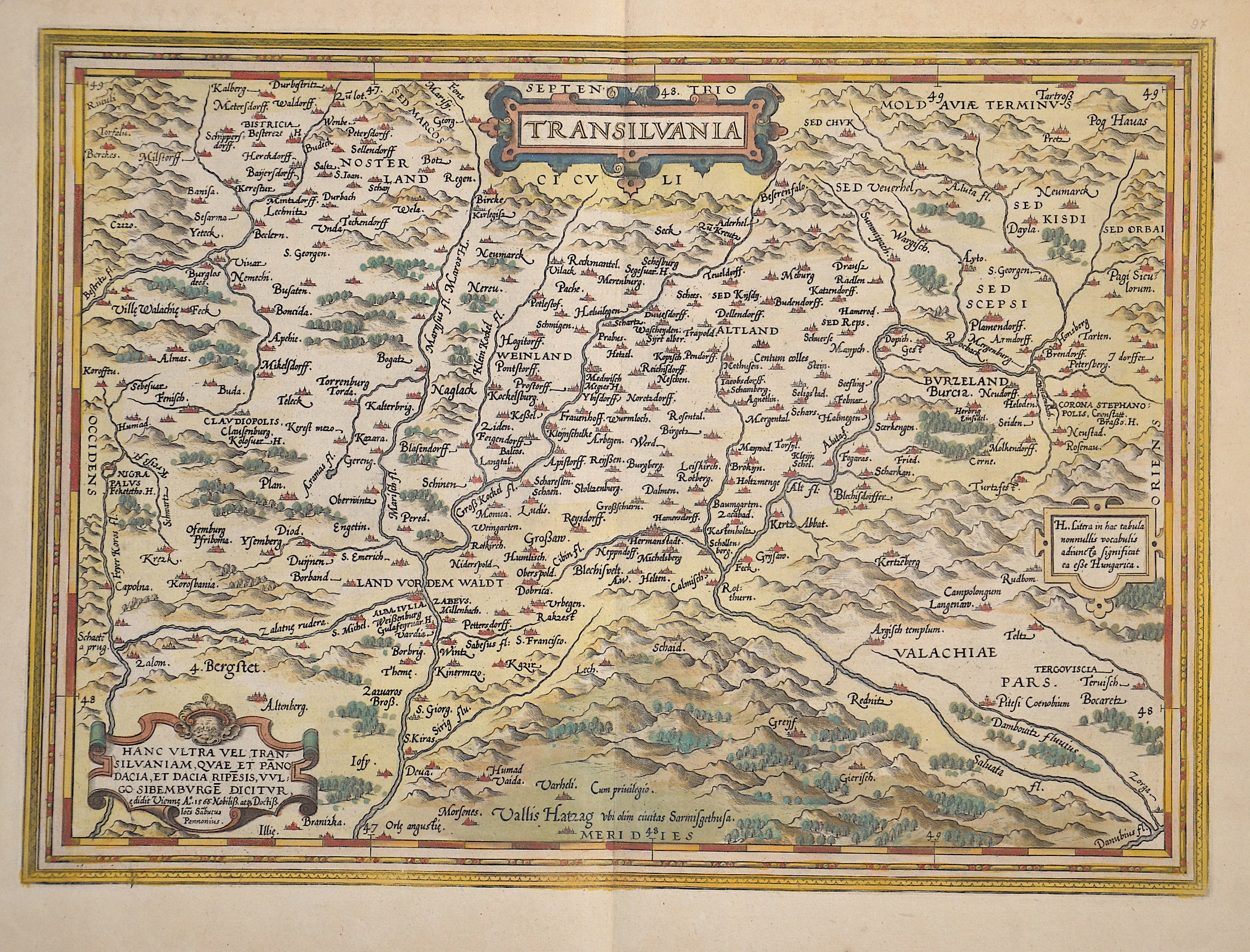
Transilvania

| Article ID | EUR812 |
Title | Transilvania |
Description | Map shows the entire Transylvania (Siebenbürgen) with parts of Wallachia. Detailed representation of all cities, forests, rivers, and mountains with 3 magnificent cartouches. |
| Year | dated 1566 |
Artist | Ortelius (1527-1598) |
Abraham Ortelius, (1527 - 1598) Antwerp, comes from an Augsburg family and was born in Antwerp, Spain, where he lived throughout his life. After thorough training, he joined the Antwerp Guild of St. Luke in 1547 as a card painter. In 1554 he took over an antiquarian bookshop that mainly deals with the coloring, distribution and publishing of maps. Basically he is more of a publisher than a scholar. And so he also made the acquaintance of another great man of his time, Gerhard Mercator (1512-1594), who encouraged him to draw cards and to make maps of the most varied of countries. His first cartographic work of his own is a large 8-sheet map of the world that appears in Antwerp in 1564. This is followed by a two-sheet map of Egypt (1565) and another of Asia (1567). The great achievement of Ortelius, who was one of the most famous European cartographers of his time, and the enthusiastic reception of his theater, mark a decisive turning point in the history of the world map. The new path is mapped out with the Theatrum. For the general view of the world, the appearance of Ortelius-Theatrum is important insofar as it emphatically confirms that America is a completely independent continent, which is also not connected to the Asian mainland mass at its northern tip. Ortelius was the first to come up with the idea of producing a handy collection of reliable maps, all kept in the same format and only by the same author for each country. These sheets could also be bound into a book for easy storage and use. Mercator, who also realized the idea of a world atlas from 1569, persuaded his friend to publish the famous Theatrum Orbis Terrarrum. Ortelius collected, traveled, corresponded and negotiated for 10 years before he could have his work printed in the best European printing house (Plantijn / Amsterdam). In addition to technical difficulties, Ortelius had to submit to the political / religious conditions, since maps were also subject to strict scrutiny during the Inquisition. Biblical scenes are pleasant, portraits of outstanding Catholics are welcome, but not family coats of arms or other emblems that could be politically suspect. On May 20, 1570, his first edition of the Theatrum Orbis Terrarum, the first collection of maps in book form, was published, financed and edited by Gillis Hooftman, an Antwerp merchant, banker and shipowner. Atlases did not yet have this name at that time. This collection was published between 1570 and 1612 in 42 editions and in 7 languages: Latin, German, Dutch, French, Spanish, English and Italian. Unlike his professional colleagues, he clearly referenced the sources of his maps and texts. The work contains, among other things, an illustration of the world known until 1492 and was therefore already looking back at the time the map was created. | |
Historical Description | The area where today's Transylvania is located was the political center of the Dacian Kingdom in ancient times. From about 895, in the course of their land seizures, the Hungarians settled the Carpathian Basin and thus also the area of present-day Transylvania. The political power in the Carpathian region fell to the Hungarians quite unresistingly compared to other land grabs of the Migration Period, as the population groups encountered there formed only some weak ruling structures. Between 1211 and 1225, the Order of Teutonic Knights was also present, which the Hungarian king Andrew II had called into the country to protect it from the Cumans in Burzenland. The Order settled its territory with German settlers. When the knights, encouraged by the Pope and the Grand Master, tried to establish their own state, they were expelled and the Burzenland was annexed to the king's territory. The region of Transylvania developed as a part of the medieval kingdom of Hungary. When the Hungarian army was devastatingly defeated by Suleyman I in the Battle of Mohács on August 29, 1526, an almost 200-year period of constant threat to the country began. The Turkish advance into Hungary (1526-1686) devastated central Hungary in particular. Suleyman I concluded a peace treaty with John Zápolya as early as 1528, counting on the weakening of the Habsburg Empire through what would later become the Principality of Transylvania. For Transylvania as a social and economic entity, the 17th century was a time of great upheaval and constant threat from outside and within. After the victory over the Ottomans at the Second Vienna Turkish Siege of 1683, Transylvania tried in vain to resist the growing influence of Austria. The Peace of Sathmar in 1711 finally established Austrian control over all of Hungary and Transylvania. Transylvania, which remained independent from the Kingdom of Hungary, was now administered by so-called gubernators under the supervision of the Viennese court. From 1733, the ethnic group of the so-called Transylvanian Landler was settled in southern Transylvania. In the meantime, the Romanians constituted the majority of the population of Transylvania. Due to their large numbers and proximity to the Kingdom of Romania, the Romanians resisted Magyarization and found themselves systematically disadvantaged by the ruling Hungarians on many levels. The takeover of Transylvania by Romania was enshrined in the Treaty of Trianon in 1920. |
| Place of Publication | Antwerp |
| Dimensions (cm) | 33 x 46 cm |
| Condition | Perfect condition |
| Coloring | original colored |
| Technique | Copper print |
Reproduction:
63.00 €
( A reproduction can be ordered individually on request. )