

Adina Sommer
Antique and Contemporary Art
Winzerer Str. 154
80797 München
telephone
+49 89 304714
business hours:
by appointment
Email
![]()


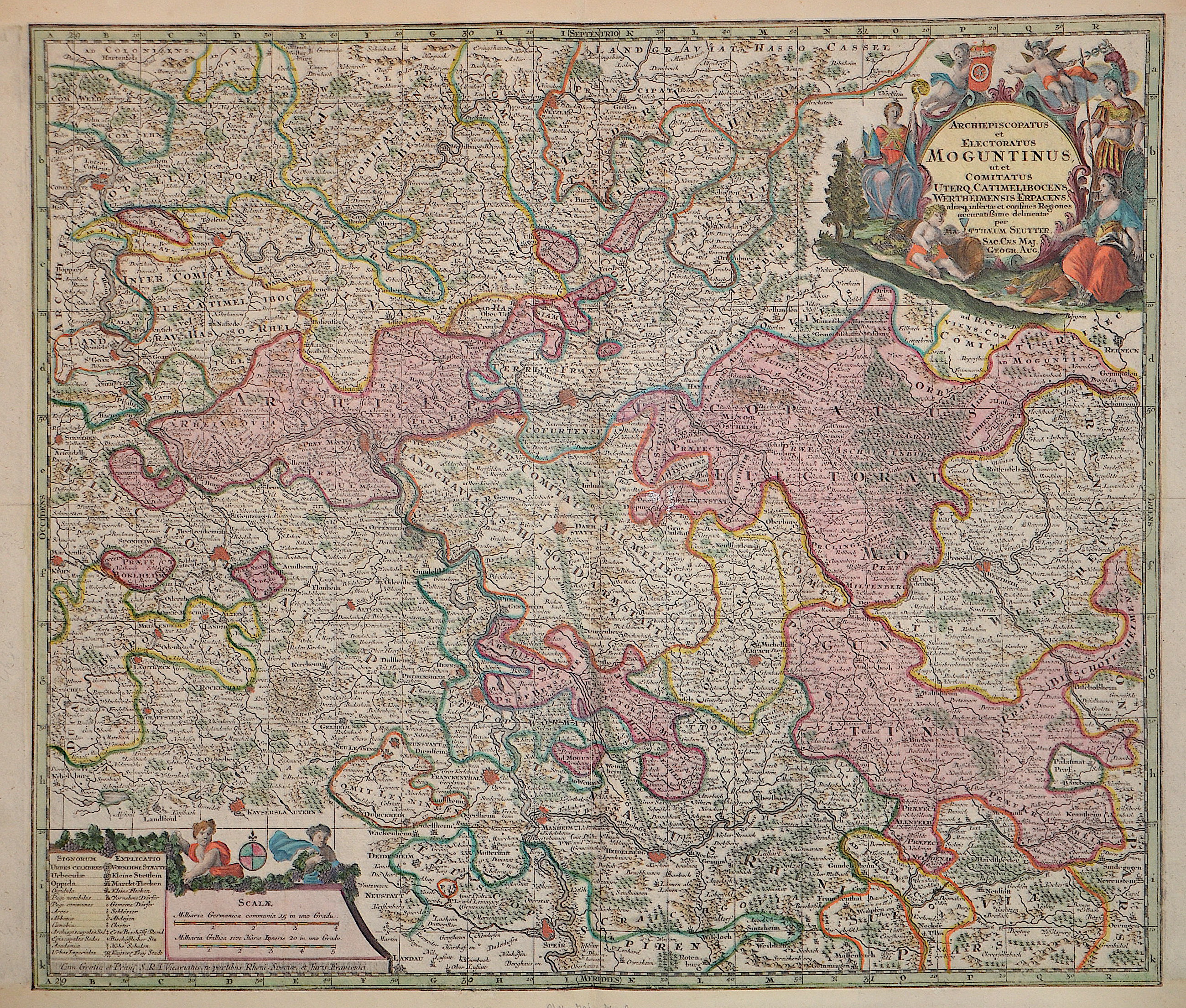
Archiepiscopatus et Electoratus Moguntinus ut et Comitatus Uterq. Catimelibocens. Wertheimensis Erpacens

| Article ID | EUD5324 |
Title | Archiepiscopatus et Electoratus Moguntinus ut et Comitatus Uterq. Catimelibocens. Wertheimensis Erpacens |
Description | Map shows the course of the Rhine from Koblenz via Mainz to Speyer and the course of the Main with Frankfurt am Main, Hanau Wertheim to Gemünden am Main. Furthermore, a title cartouche with the coat of arms of the Mainz diocese, the god of wine (Bacchus), the goddess of the hunt (Diana), Hermes, Ares and a mileage indicator cartouche with index. |
| Year | ca. 1740 |
Artist | Seutter (1678-1757) |
Matthias Seutter (1678- 1757) Augsburg was the son of a goldsmith in Augsburg. In 1697, Seutter began his studies in Nuremberg and subsequently worked in the publishing house of Jeremias Wolff in Augsburg. In 1710, he established his own publishing house and print shop. The Seutter publishing house produced a great number of maps, atlases, and globes. However, very few original maps were printed there, as Augsburg at that time had no university and no connection to the fields of mathematics or the natural sciences. Seutter therefore copied the work of other cartographers, making his own engravings based on their models. Over 500 maps were produced in his studio. Seutter's most well-known works are the 1725 "Geographical Atlas or an Accurate Depiction of the Whole World" ("Atlas Geographicus oder Accurate Vorstellung der ganzen Welt") with 46 maps, the 1734 "Large Atlas" ("Grosser Atlas") with 131 maps, and the 1744 pocket atlas "Small Atlas" ("Atlas minor") with 64 maps. Matthäus Seutter died in 1757. Seutter's son Albrecht Karl, his son-in-law Conrad Tobias Lotter, and his business partner Johann Michael Probst ran the printing business for five more years. | |
Historical Description | Rhineland-Palatinate is surrounded by the states of North Rhine-Westphalia, Saarland, Baden-Württemberg and Hesse. It also borders three foreign countries: France, Luxembourg and Belgium. Rhineland-Palatinate was established in 1946 after World War II, from territory of the historically separate regions of the Free State of Prussia, the People's State of Hesse and Bavaria, by the French military administration in Allied-occupied Germany. Rhineland-Palatinate became part of the Federal Republic of Germany in 1949 and shared the country's only border with the Saar Protectorate until it was returned to German control in 1957. Rhineland-Palatinate has since developed its own identity built on its natural and cultural heritage, including the extensive Palatinate winegrowing region, its picturesque landscapes, and its many castles and palaces. |
| Place of Publication | Augsburg |
| Dimensions (cm) | 49 x 57 cm |
| Condition | Upper and lower margin replaced and assembled |
| Coloring | original colored |
| Technique | Copper print |
Reproduction:
57.00 €
( A reproduction can be ordered individually on request. )