

Adina Sommer
Antique and Contemporary Art
Winzerer Str. 154
80797 München
telephone
+49 89 304714
business hours:
by appointment
Email
![]()


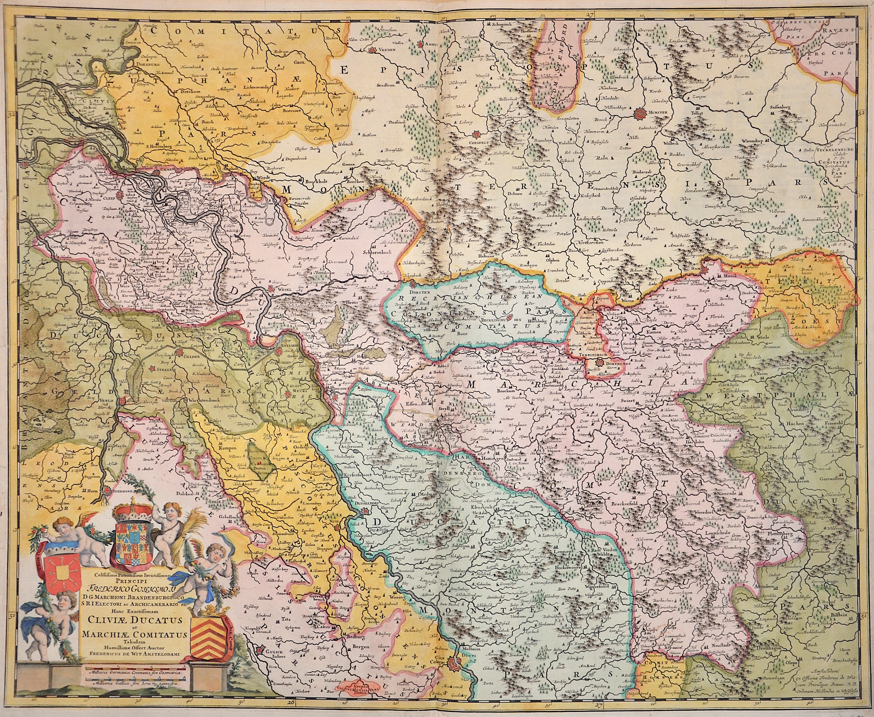
…Cliviae Ducatus et Marchiae Comitatus..

| Article ID | EUD0037 |
Title | …Cliviae Ducatus et Marchiae Comitatus.. |
Description | Map shows North Rhine-Westphalia with the Rhine, Emmerich, Düsseldorf and Cologne. There is also a magnificent title cartouche with three coats of arms and four putti.e |
| Year | ca. 1680 |
Artist | Wit, de (1610-1698) |
Frederik de Wit (1610 – 1698). His Atlas began to appear around 1662 and by 1671 included anywhere from 17 to 151 maps each. In the 1690s he began to use a new title page "Atlas Maior" but continued to use his old title page. His atlas of the Low Countries first published in 1667,was named Nieuw Kaertboeck van de XVII Nederlandse Provinciën and contained 14 to 25 maps. Frederik de Wit quickly expanded upon his first small folio atlas which contained mostly maps printed from plates that he had acquired, to an atlas with 27 maps engraved by or for him. By 1671 he was publishing a large folio atlas with as many as 100 maps. Smaller atlases of 17 or 27 or 51 maps could still be purchased and by the mid-1670s an atlas of as many as 151 maps and charts could be purchased from his shop. In ca.1675 Frederik de Wit released a new nautical atlas. The charts in this atlas replaced the earlier charts from 1664 that are known today in only four bound examples and a few loose copies. Frederik de Wit new charts were sold in a chart book and as part of his atlases. Frederik de Wit published no fewer than 158 land maps and 43 charts on separate folio sheets. In 1695 Frederik de Wit began to publish a town atlas of the Netherlands after he acquired a large number of city plans at the auction of the famous Blaeu publishing firm’s printing plates. Dating Frederik de Wit atlases is considered difficult because usually no dates were recorded on the maps and their dates of publication extended over many years. | |
Historical Description | The first written account of the area was by its conqueror, Julius Caesar, the territories west of the Rhine were occupied by the Eburones and east of the Rhine he reported the Ubii (across from Cologne) and the Sugambri to their north. The Ubii and some other Germanic tribes such as the Cugerni were later settled on the west side of the Rhine in the Roman province of Germania Inferior. Julius Caesar conquered the tribes on the left bank, and Augustus established numerous fortified posts on the Rhine, but the Romans never succeeded in gaining a firm footing on the right bank, where the Sugambri neighboured several other tribes including the Tencteri and Usipetes. North of the Sigambri and the Rhine region were the Bructeri. and by the end of the fifth century had conquered all the lands that had formerly been under Roman influence. By the eighth century, the Frankish dominion was firmly established in western Germany and northern Gaul, but at the same time, to the north, Westphalia was being taken over by Saxons pushing south. As the central power of the Holy Roman Emperor weakened, the Rhineland split into numerous small, independent, separate vicissitudes and special chronicles. Prussia first set foot on the Rhine in 1609 by the occupation of the Duchy of Cleves and about a century later Upper Guelders and Moers also became Prussian. At the peace of Basel in 1795, the whole of the left bank of the Rhine was resigned to France, and in 1806, the Rhenish princes all joined the Confederation of the Rhine. After the Congress of Vienna, Prussia was awarded the entire Rhineland, which included the Grand Duchy of Berg, the ecclesiastic electorates of Trier and Cologne, the free cities of Aachen and Cologne, and nearly a hundred small lordships and abbeys. The Prussian Rhine province was formed in 1822 and Prussia had the tact to leave them in undisturbed possession of the liberal institutions to which they had become accustomed under the republican rule of the French. In 1920, the districts of Eupen and Malmedy were transferred to Belgium (see German-speaking Community of Belgium). After the Congress of Vienna, the Kingdom of Prussia received a large amount of territory in the Westphalian region and created the province of Westphalia in 1815. The northernmost portions of the former kingdom, including the town of Osnabrück, had become part of the states of Hanover and Oldenburg. |
| Place of Publication | Amsterdam |
| Dimensions (cm) | 48 x 59 cm |
| Condition | Some restoration at lower centerfold |
| Coloring | colored |
| Technique | Copper print |
Reproduction:
70.50 €
( A reproduction can be ordered individually on request. )