

Adina Sommer
Antique and Contemporary Art
Winzerer Str. 154
80797 München
telephone
+49 89 304714
business hours:
by appointment
Email
![]()


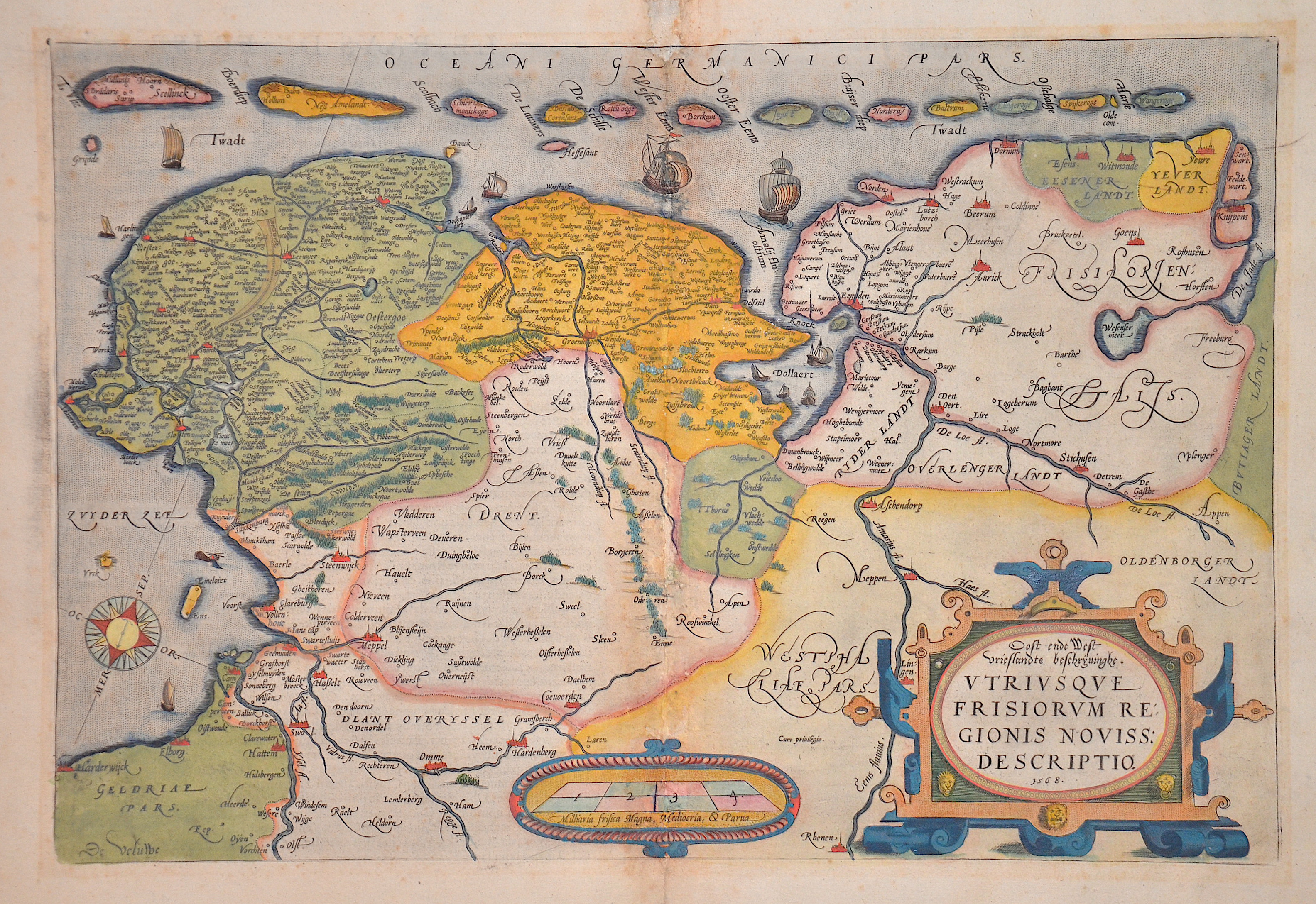
Le Pays de Frise. / Oost ende West vrieslandts beschryuinghe. Utriusque Frisiorum Regionis noviss. Descriptio. 1568

| Article ID | EUD5264 |
Title | Le Pays de Frise. / Oost ende West vrieslandts beschryuinghe. Utriusque Frisiorum Regionis noviss. Descriptio. 1568 |
Description | Map shows West and East Frisia and the offshore islands. Furthermore, several ship staffages, a compass rose, a mileage indicator and a scroll title cartouche. French edition |
| Year | ca. 1587 |
Artist | Ortelius (1527-1598) |
Abraham Ortelius, (1527 - 1598) Antwerp, comes from an Augsburg family and was born in Antwerp, Spain, where he lived throughout his life. After thorough training, he joined the Antwerp Guild of St. Luke in 1547 as a card painter. In 1554 he took over an antiquarian bookshop that mainly deals with the coloring, distribution and publishing of maps. Basically he is more of a publisher than a scholar. And so he also made the acquaintance of another great man of his time, Gerhard Mercator (1512-1594), who encouraged him to draw cards and to make maps of the most varied of countries. His first cartographic work of his own is a large 8-sheet map of the world that appears in Antwerp in 1564. This is followed by a two-sheet map of Egypt (1565) and another of Asia (1567). The great achievement of Ortelius, who was one of the most famous European cartographers of his time, and the enthusiastic reception of his theater, mark a decisive turning point in the history of the world map. The new path is mapped out with the Theatrum. For the general view of the world, the appearance of Ortelius-Theatrum is important insofar as it emphatically confirms that America is a completely independent continent, which is also not connected to the Asian mainland mass at its northern tip. Ortelius was the first to come up with the idea of producing a handy collection of reliable maps, all kept in the same format and only by the same author for each country. These sheets could also be bound into a book for easy storage and use. Mercator, who also realized the idea of a world atlas from 1569, persuaded his friend to publish the famous Theatrum Orbis Terrarrum. Ortelius collected, traveled, corresponded and negotiated for 10 years before he could have his work printed in the best European printing house (Plantijn / Amsterdam). In addition to technical difficulties, Ortelius had to submit to the political / religious conditions, since maps were also subject to strict scrutiny during the Inquisition. Biblical scenes are pleasant, portraits of outstanding Catholics are welcome, but not family coats of arms or other emblems that could be politically suspect. On May 20, 1570, his first edition of the Theatrum Orbis Terrarum, the first collection of maps in book form, was published, financed and edited by Gillis Hooftman, an Antwerp merchant, banker and shipowner. Atlases did not yet have this name at that time. This collection was published between 1570 and 1612 in 42 editions and in 7 languages: Latin, German, Dutch, French, Spanish, English and Italian. Unlike his professional colleagues, he clearly referenced the sources of his maps and texts. The work contains, among other things, an illustration of the world known until 1492 and was therefore already looking back at the time the map was created. | |
Historical Description | The name Saxony is derived from that of the Germanic confederation of tribes called Saxons. Before the late Middle Ages there was a single duchy of Saxony. The term "Lower Saxony" was used after the dissolution of the original duchy in the late 13th century to distinguish the parts of the former duchy that were ruled by the House of Welfare, on the one hand from the electorate of Saxony and from the duchy of Westphalia on the other. The name and coat of arms of today's state go back to the Germanic tribe of the Saxons. During the migration period, some of the Saxon peoples left their homeland in Holstein around the 3rd century and advanced south across the Elbe, where they expanded into the sparsely populated regions in the rest of the lowlands in today's northwestern Germany and the northeastern part of today's Netherlands. From the 7th century onwards, the Saxons occupied a settlement area that roughly corresponds to today's federal state of Lower Saxony, Westphalia and a number of areas in the east, for example in today's west and north Saxony-Anhalt. From the 14th century onwards it referred to the Duchy of Saxony-Lauenburg (as opposed to Saxony-Wittenberg). When the imperial districts were created in 1500, a distinction was made between a district in Lower Saxony and a district in Lower Rhine-Westphalia. The latter comprised the following areas, which today belong wholly or partially to the state of Lower Saxony: the Diocese of Osnabrück, the Diocese of Münster, the County of Bentheim, the County of Hoya, the Principality of East Friesland, the Principality of Verden, the district of Diepholz, the district of Oldenburg, the district of Schaumburg and the district of Spiegelberg .The close historical links between the domains of the Lower Saxon Circle now in modern Lower Saxony survived for centuries especially from a dynastic point of view. The majority of historic territories whose land now lies within Lower Saxony were sub-principalities of the medieval, Welf estates of the Duchy of Brunswick-Lüneburg. All the Welf princes called themselves dukes "of Brunswick and Lüneburg" despite often ruling parts of a duchy that was forever being divided and reunited as various Welf lines multiplied or died out. |
| Place of Publication | Antwerp |
| Dimensions (cm) | 34 x 51 cm |
| Condition | Restoration at centerfold and missing part replaced |
| Coloring | original colored |
| Technique | Copper print |
Reproduction:
93.00 €
( A reproduction can be ordered individually on request. )