

Adina Sommer
Antique and Contemporary Art
Winzerer Str. 154
80797 München
telephone
+49 89 304714
business hours:
by appointment
Email
![]()


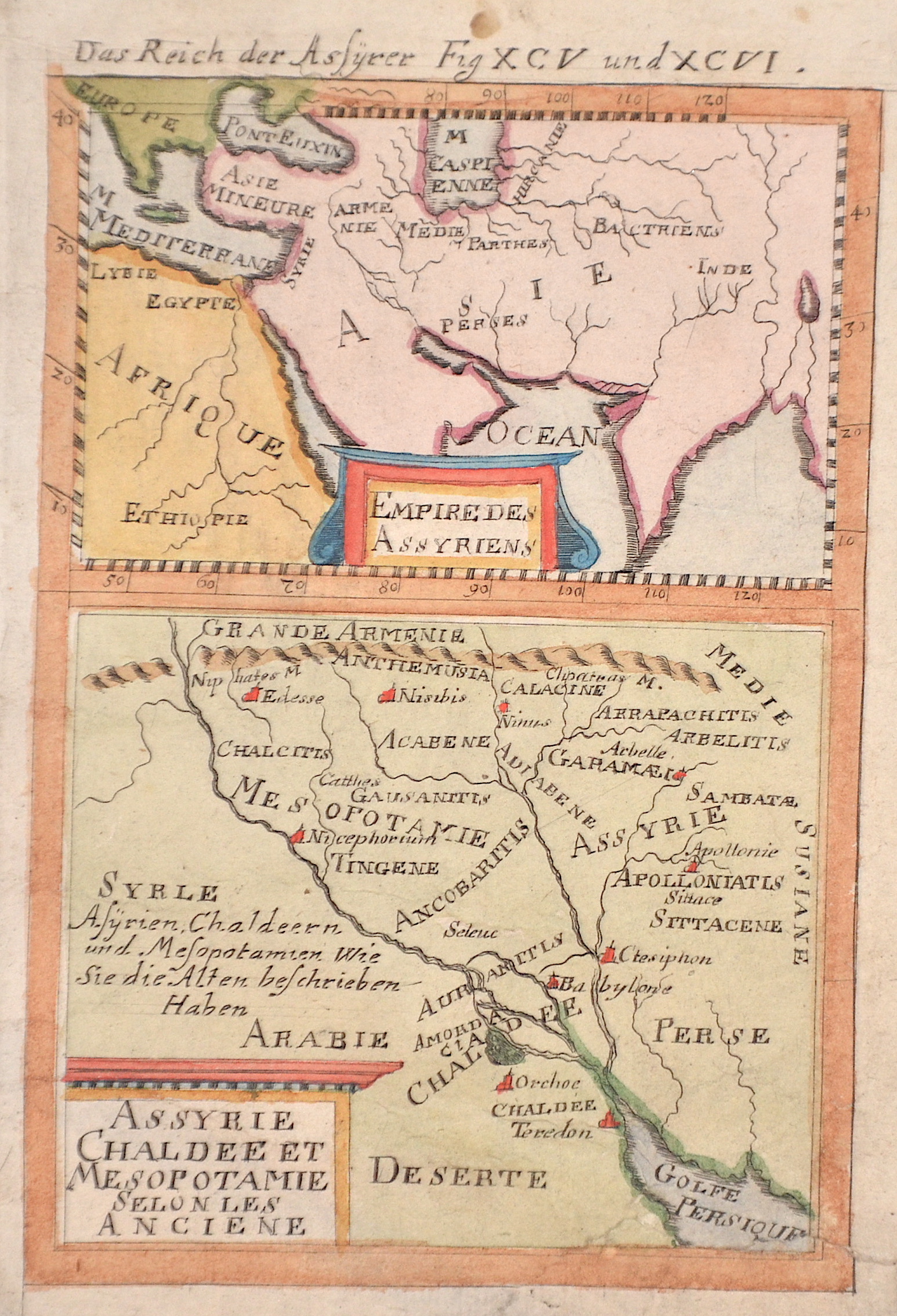
Das Reich der Assyrer Fig XCV und XCVI. / Empire des Assyriens / Assyrie Chaldee et Mesopotamie selon les Anciene

| Article ID | ASX1389 |
Title | Das Reich der Assyrer Fig XCV und XCVI. / Empire des Assyriens / Assyrie Chaldee et Mesopotamie selon les Anciene |
Description | Two maps on one sheet Upper map shows the south-east of Asia with title cartouche. The lower map shows Assyria (an ancient landscape in northern Mesopotamia) and Babylonia (a landscape on the lower reaches of the Euphrates and Tigris rivers, between the present-day Iraqi city of Baghdad and the Persian Gulf). |
| Year | ca. 1684 |
Artist | Mallet (1630-1706) |
Alain Manesson Mallet (1630- 1706 ) was a French cartographer and engineer. He started his career as a soldier in the army of Louis XIV, became a Sergeant-Major in the artillery and an Inspector of Fortifications. He also served under the King of Portugal, before returning to France, and his appointment to the court of Louis XIV. His military engineering and mathematical background led to his position teaching mathematics at court. His major publications were Description de L'Univers (1683) in 5 volumes, and Les Travaux de Mars ou l'Art de la Guerre (1684) in 3 volumes. His Description de L'Universe contains a wide variety of information, including star maps, maps of the ancient and modern world, and a synopsis of the customs, religion and government of the many nations included in his text. It has been suggested that his background as a teacher led to his being concerned with entertaining his readers. This concern manifested itself in the charming harbor scenes and rural landscapes that he included beneath his description of astronomical concepts and diagrams. Mallet himself drew most of the figures that were engraved for this book. | |
Historical Description | The Republic of Iraq is a state in the Middle East. Iraq borders Kuwait, Saudi Arabia, Jordan, Syria, Turkey, Iran and the Persian Gulf and encompasses most of Mesopotamia, the “land of two rivers” located between the Euphrates and Tigris rivers. From the 4th millennium BC, some of the earliest advanced civilizations of mankind emerged here (Sumer, Akkad, Assyria, Babylonia, Mittani, Media), which is why the region is seen by many today as the cradle of civilization. After the Battle of Kadesia in 636, the Arab Muslims took control of the region. Iraq became an important cultural center of the expanding Islam. In 762, Baghdad was founded by al-Mansur as the capital of the Abbasid Caliphate and soon developed into the most important city in the Islamic world. The following period is also known as the heyday of Islam, in which science and the arts in particular developed to a significantly higher level than in Europe, for example. Baghdad was devastated by Timur, and in 1534 the country fell to the Ottoman Empire. For a long time, Iraq remained an insignificant sideshow; however, its geostrategic position at the crossroads between Europe, British India, Central Asia, the Caucasus and southern Arabia made it an object of global political interest from the First World War onwards. |
| Place of Publication | Frankfurt on Main |
| Dimensions (cm) | 15,5 x 10,3 cm |
| Condition | Tear on lower right part perfectly restored |
| Coloring | colored |
| Technique | Copper print |
Reproduction:
10.50 €
( A reproduction can be ordered individually on request. )