

- Alsace
- Aquitaine
- Auvergne
- Bourgogne
- Bourgogne-Franche-Comté
- Brittany
- Centre
- Champagne
- Flandre
- France Islands
- Gascogne
- Gironde
- Hauts-de-France
- Ile de France
- Languedoc
- Lothringen
- Midi-Pyrénées
- Nivernais
- Nord-Pas-de-Calais
- Normandie
- Occitanie
- Paris
- Pas-de-Calais
- Pays de la Loire
- Picardie
- Poitou-Charentes
- Provence-Alpes-Cote d Azur
- Pyrénées
- Rhone- Alpes
- Saintonge
- Savoyen
- Tourain
- Westcoast
Adina Sommer
Antique and Contemporary Art
Winzerer Str. 154
80797 München
telephone
+49 89 304714
business hours:
by appointment
Email
![]()


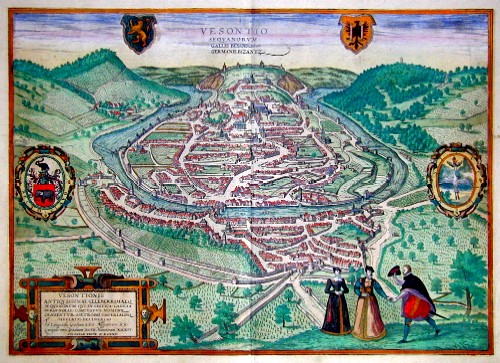
Vesontio sequanurum Gallis Besanson Germanis Byzantz

| Article ID | EUF1479 |
Title | Vesontio sequanurum Gallis Besanson Germanis Byzantz |
Description | Map shows the sity of Besanco as bird´s eye view. The town, which was founded in a bend of the Doubs river, played an important role during the Roman Empire under the name Vesontio. In the Middle Ages, Besançon succeeded in gaining and maintaining its status as an imperial city in the Holy Roman Empire. During the 17th century, the region that is now Franche-Comté was fiercely contested, and Besançon only became part of France in 1678. |
| Year | ca. 1595 |
Artist | Braun/Hogenberg (1572-1618) |
Frans Hogenberg (1535 – 1590) was a Flemish and German painter, engraver, and mapmaker. Hogenberg was born in Mechelen as the son of Nicolaas Hogenberg In 1568 he was banned from Antwerp by the Duke of Alva. He travelled to London, where he stayed a few years before emigrating to Cologne. He is known for portraits and topographical views as well as historical allegories. He also produced scenes of contemporary historical events. George Braun (1541-1622), a cleric of Cologne, was the principal editor of the "Civitates Orbis Terrarum". The first volume of the Civitates Orbis Terrarum was published in Cologne in 1572. The sixth and the final volume appeared in 1617. This great city atlas, edited by Georg Braun and largely engraved by Franz Hogenberg, eventually contained 546 prospects, bird-eye views and map views of cities from all over the world. Braun (1541-1622), a cleric of Cologne, was the principal editor of the work, and was greatly assisted in his project by the close, and continued interest of Abraham Ortelius, whose Theatrum Orbis Terrarum of 1570 was, as a systematic and comprehensive collection of maps of uniform style, the first true atlas. | |
Historical Description | Franche-Comté, the Free County of Burgundy, is a historical province in eastern France and was an administrative region of the Fifth French Republic from 1960 to 2015. n the early historical period, Franche-Comté was settled by the Sequans tribe. Their capital Vesontio was located on the site of modern-day Besançon. Barbarossa separated the region from the rest of Burgundy in 1169 and elevated it to a county palatine. The French name for the free county was la Franche-Comté. The area was of enormous economic importance to the Confederates, as most salt and metal imports came from there - especially from Salins-les-Bains - and salt was also essential for cheese production. Louis XIV occupied the Free County militarily during the War of Devolution in 1668 and the Dutch War in 1674. In the Peace of Nijmegen in 1678, Spain had to cede the Free County to France. Until 1790 (French Revolution), Franche-Comté was one of the historical provinces of France. The area around Belfort is not historically part of Franche-Comté, but used to belong to Alsace. The Franche-Comté region was created with the establishment of the regions in 1960. |
| Place of Publication | Cologne |
| Dimensions (cm) | 35,5 x 49,5 |
| Condition | Very good |
| Coloring | original colored |
| Technique | Copper print |
Reproduction:
87.00 €
( A reproduction can be ordered individually on request. )