

Adina Sommer
Antique and Contemporary Art
Winzerer Str. 154
80797 München
telephone
+49 89 304714
business hours:
by appointment
Email
![]()


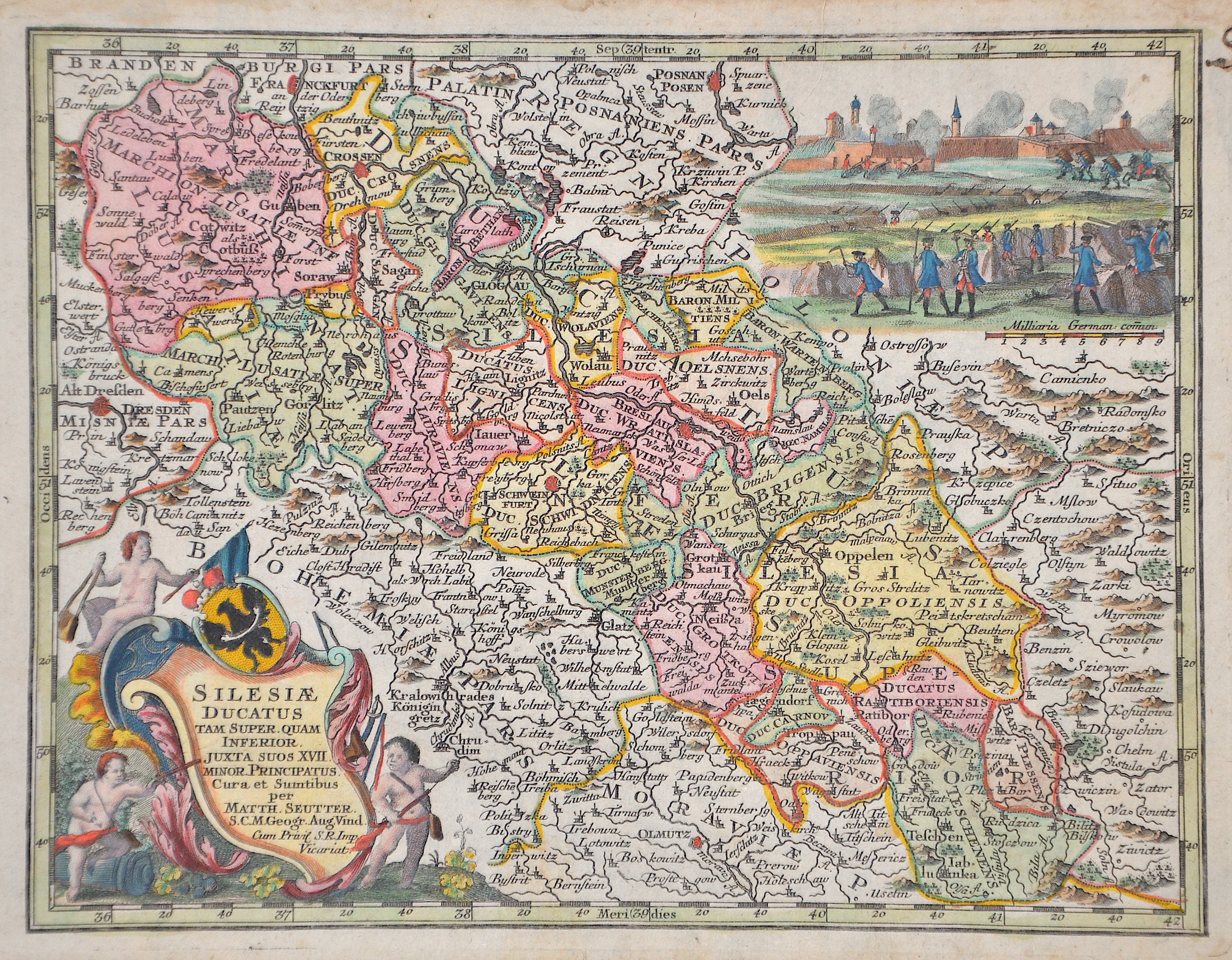
Silesiae Ducatus tam super. Quam inferior.

| Article ID | EUP5210 |
Title | Silesiae Ducatus tam super. Quam inferior. |
Description | Map shows the whole of Silesia with 2 splendid cartouches. |
| Year | ca. 1744 |
Artist | Seutter (1678-1757) |
Matthias Seutter (1678- 1757) Augsburg was the son of a goldsmith in Augsburg. In 1697, Seutter began his studies in Nuremberg and subsequently worked in the publishing house of Jeremias Wolff in Augsburg. In 1710, he established his own publishing house and print shop. The Seutter publishing house produced a great number of maps, atlases, and globes. However, very few original maps were printed there, as Augsburg at that time had no university and no connection to the fields of mathematics or the natural sciences. Seutter therefore copied the work of other cartographers, making his own engravings based on their models. Over 500 maps were produced in his studio. Seutter's most well-known works are the 1725 "Geographical Atlas or an Accurate Depiction of the Whole World" ("Atlas Geographicus oder Accurate Vorstellung der ganzen Welt") with 46 maps, the 1734 "Large Atlas" ("Grosser Atlas") with 131 maps, and the 1744 pocket atlas "Small Atlas" ("Atlas minor") with 64 maps. Matthäus Seutter died in 1757. Seutter's son Albrecht Karl, his son-in-law Conrad Tobias Lotter, and his business partner Johann Michael Probst ran the printing business for five more years. | |
Historical Description | Silesia is a region in Central Europe on both sides of the upper and middle reaches of the Oder and extends in the south along the Sudetes and Beskids. Most of Silesia lies in what is now Poland. A small part in the west of Lower Silesia belongs to East Germany, a southern part of Upper Silesia to the Czech Republic. Between 1289 and 1292, Bohemian king Wenceslaus II became suzerain of some of the Upper Silesian duchies. Polish kings had not renounced their hereditary rights to Silesia until 1335. The province became part of the Bohemian Crown under the Holy Roman Empire, and passed with that crown to the Habsburg Monarchy of Austria in 1526. In the 15th century, several changes were made to Silesia's borders. Parts of the territories which had been transferred to the Silesian Piasts in 1178 were bought by the Polish kings in the second half of the 15th century. From 1526 to 1742 the Habsburgs, as kings of Bohemia, were also dukes of Silesia. Almost all of Silesia became Protestant in the 16th century. Well-known Silesian reformers were among others Johann Heß and Caspar von Schwenckfeld, whose theology was invoked by the Schwenkfeldians, who were represented in Silesia until the 17th century. After the First Silesian War it was agreed in the preliminary peace of Breslau (1742) that Austria had to cede Lower and Upper Silesia to the Oppa as well as the Bohemian County of Glatz to Prussia. Frederick the Great was able to defend this acquisition in the Second Silesian War and also in the Third Silesian War (1756 to 1763). A smaller part of Upper Silesia around Troppau, Jägerndorf, Teschen and Bielitz as well as the southern part of the Principality of Neisse, which belongs to Lower Silesia (= the political district of Freiwaldau until 1938) remained as Austrian Silesia (officially: "Duchy of Upper and Lower Silesia") until 1918 of the Austro-Hungarian monarchy. First (until 1782) as part of the Kingdom of Bohemia, then (until 1849 and 1860–1861) Moravia. According to a decree of March 4, 1849, all peoples of the Austrian Empire, including Silesians, were given equal rights. |
| Place of Publication | Augsburg |
| Dimensions (cm) | 20 x 26 cm |
| Condition | Perfect condition |
| Coloring | original colored |
| Technique | Copper print |
Reproduction:
39.00 €
( A reproduction can be ordered individually on request. )