

Adina Sommer
Antique and Contemporary Art
Winzerer Str. 154
80797 München
telephone
+49 89 304714
business hours:
by appointment
Email
![]()


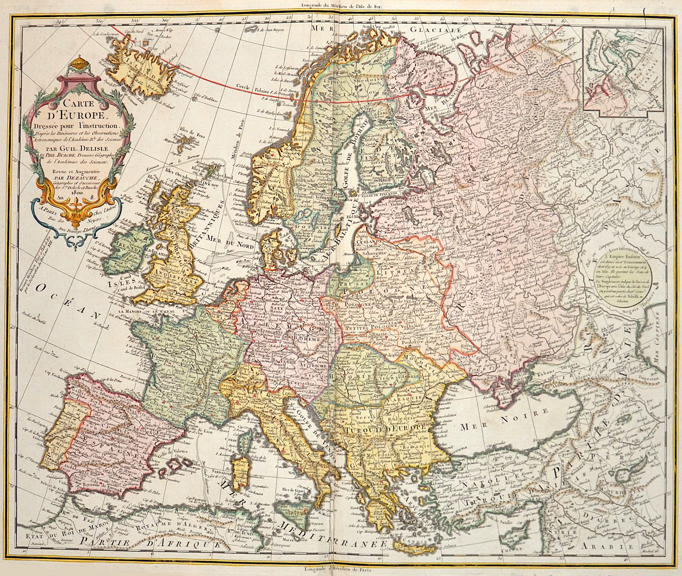
Carte d´Europe. dresse pour l ´instruction…..

| Article ID | EUX2744 |
Title | Carte d´Europe. dresse pour l ´instruction….. |
Description | Map shows total Europe with a small instet map of Nova Zembla |
| Year | dated 1800 |
Artist | Dezauche (1780-1838) |
Jean-Claude Dezauche (1780-1838) was the successor to Guillaume De L'Isle and Philipe Buache. Guillaume De L´Isle (1675- 1726) Paris, was a French cartographer known for his popular and accurate maps of Europe and the newly explored Americas and Africa. De L´Isle was admitted into the French Académie Royale des Sciences, an institution financed by the French state. After that date, he signed his maps with the title of “Géographe de l’Académie”. Five years later, he moved to the Quai de l’Horloge in Paris, a true publishing hub where his business prospered. De L´Isle’s ascension through the ranks culminated in 1718 when he received the title of Premier Géographe du Roi. His new office consisted in teaching geography to the Dauphin, King Louis XIV’s son, a task for which he received a salary. De L´Isle’s reputation as a man of science probably helped .This supports the claim of the historian Mary Sponberg Pedley, who says “once authority was established, a geographer’s name might retain enough value to support two or three generations of mapmakers”. In De L´Isle’s case, it could be said that his accomplishments surpassed his father’s. Up to that point, he had drawn maps not only of European countries, such as Italy, Spain, Germany, Great Britain, Poland, and regions such as the Duchy of Burgundy, but he had also contributed to the empire’s claims to recently explored continents of Africa and the Americas. Like many cartographers of these days, De L´Isle did not travel with the explorers and elaborated the maps mostly in his office. The quality of his maps depended on a solid network that would provide him first-hand information. Given the family’s reputation and his own, De L´Isle had access to fairly recent accounts of travellers who were coming back from the New World, which gave him an advantage over his competitors. Being a member of the Académie, he was also aware of recent discoveries, especially in astronomy and measurement. When he could not confirm the accuracy of his source, he would indicate it clearly on his maps. For instance, his Carte de la Louisiane shows a river that the baron of Lahontan claimed he discovered, but no one else could validate it, so De L`lsle warned the viewer that its actual existence was in doubt. De L´Isle 's search for exactitude and intellectual honesty entangled him in a legal dispute in 1700 with Jean-Baptiste Nolin, a fellow cartographer. Noticing Nolin had used details that were considered original from his Map of the World, De L´isle dragged Nolin in court to prove his plagiarism. In the end, Delisle managed to convince the jury of scientists that Nolin only knew the old methods of cartography and therefore that he had stolen the information from his manuscript. Nolin's maps were confiscated and he was forced to pay the court costs.The scientificity of the work produced by the De L´Isle family contrasted with the workshop of Sanson. While Sanson knowingly published outdated facts and mistakes, De L´Isle strived to present up-to-date knowledge. | |
Historical Description | The history of Europe from the 15th to the 19th century was shaped by profound political, social, and cultural changes that formed modern Europe. At the beginning of the 15th century, Europe was marked by the effects of the Middle Ages and the feudal structure. A significant event was the Renaissance, which began around 1400 in Italy and marked a revival of classical ancient culture, art, and sciences. The invention of the printing press by Johannes Gutenberg around 1440 was also revolutionary and promoted the spread of knowledge. By the end of the century, European explorers, such as Christopher Columbus, began finding new trade routes, which led to the discovery of the New World. The 16th century was defined by the Reformation, when Martin Luther published his 95 Theses in 1517, challenging the Catholic Church. This led to religious conflicts and the division of Western Christianity into Catholics and Protestants. Politically, Europe saw the rise of the Habsburg Empire and the development of nation-states such as France and England. The age of exploration continued, leading to a new wave of colonization. The 17th century was a time of wars and political instability, including the Thirty Years' War (1618–1648), which devastated much of Europe. These conflicts resulted in significant territorial changes and the establishment of the modern Treaty of Westphalia in 1648. During this time, Absolutism took root, with monarchs like Louis XIV of France exercising absolute power. The 18th century was marked by the ideas of the Enlightenment, which emphasized reason, science, and individual freedom. This led to profound political and social reforms. At the same time, major wars such as the War of Spanish Succession (1701–1714) and the Seven Years' War (1756–1763) took place. The century ended with the events of the French Revolution (1789), which overthrew the monarchy and established the Republic. This paved the way for the Napoleonic Wars and the Napoleonic Era, which triggered political and social upheavals throughout Europe. The 19th century was shaped by the aftermath of the French Revolution and the Napoleonic Wars, which reshaped Europe's political system. After Napoleon's defeat in 1815, Europe was reorganized at the Congress of Vienna. Nationalism and Liberalism grew, leading to significant political upheavals, including the German Confederation, the unification of Italy, and the formation of the German Empire in 1871. At the same time, industrialization and urbanization began, significantly altering Europe's economic and social structure. The 19th century ended with the outbreak of World War I in 1914, which shattered the entire European power structure and many social systems. |
| Place of Publication | Paris |
| Dimensions (cm) | 50,5 x 61,5 |
| Condition | Some restoration at centerfold |
| Coloring | original colored |
| Technique | Copper print |
Reproduction:
60.00 €
( A reproduction can be ordered individually on request. )