

Adina Sommer
Antique and Contemporary Art
Winzerer Str. 154
80797 München
telephone
+49 89 304714
business hours:
by appointment
Email
![]()


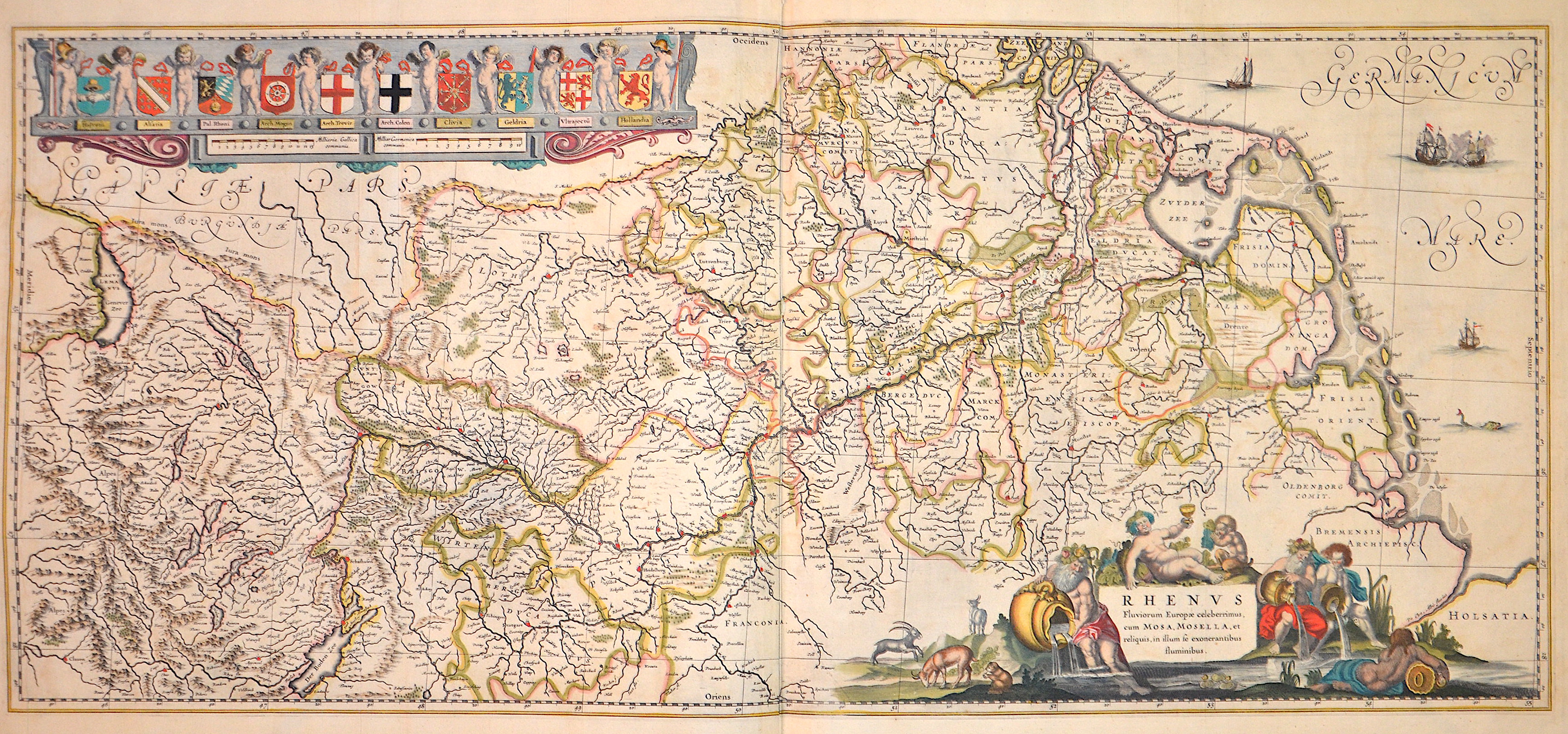
Rhenus Fluviorum Europae celeberrimus, cum Mosa, Mosella, et reliquis, in illum se exonarantibus fluminibus

| Article ID | EUX2003 |
Title | Rhenus Fluviorum Europae celeberrimus, cum Mosa, Mosella, et reliquis, in illum se exonarantibus fluminibus |
Description | Map shows the course of the Rhine from Lake Constance to its mouth in the North Sea. At the bottom right is a title cartouche with the river gods Rhine, Moselle, Mosa and Bacchus, the god of wine. At the top left a decorative cartouche with ten coats of arms held in a row by 11 putti, below two mileage scales. |
| Year | ca. 1640 |
Artist | Janssonius (1588-1664) |
Johannes Janssonius (Jansson)( 1588- 1664) Amsterdam, was born in Arnhem, the son of Jan Janszoon the Elder, a publisher and bookseller. In 1612 he married Elisabeth de Hondt, the daughter of Jodocus Hondius. He produced his first maps in 1616 of France and Italy. In 1623 Janssonius owned a bookstore in Frankfurt am Main, later also in Danzig, Stockholm, Copenhagen, Berlin, Königsberg, Geneva and Lyon. In the 1630s he formed a partnership with his brother in law Henricus Hondius, and together they published atlases as Mercator/Hondius/Janssonius. Under the leadership of Janssonius the Hondius Atlas was steadily enlarged. Renamed Atlas Novus, it had three volumes in 1638, one fully dedicated to Italy. 1646 a fourth volume came out with ""English County Maps"", a year after a similar issue by Willem Blaeu. Janssonius' maps are similar to those of Blaeu, and he is often accused of copying from his rival, but many of his maps predate those of Blaeu and/or covered different regions. By 1660, at which point the atlas bore the appropriate name ""Atlas Major"", there were 11 volumes, containing the work of about a hundred credited authors and engravers. It included a description of ""most of the cities of the world"" (Townatlas), of the waterworld (Atlas Maritimus in 33 maps), and of the Ancient World (60 maps). The eleventh volume was the Atlas of the Heavens by Andreas Cellarius. Editions were printed in Dutch, Latin, French, and a few times in German. | |
Historical Description | The Rhine is one of the most important rivers in Europe and has played a significant role in the history and development of the region. It connects several countries, including Switzerland, Germany, France, and the Netherlands. In ancient Europe, the Rhine was an important border, separating the Roman Empire from the Germanic tribes to the north. The Romans used the Rhine as a trade and transport route and built several fortresses along the river to secure their border, including the well-known Limes (border fortifications). The Rhine played a central role in the spread of Roman culture and civilization in the areas along the river. In the Middle Ages, the Rhine was not only an important trade route but also a strategic political point. Cities like Cologne, Mainz, and Speyer along the Rhine developed into important commercial centers. The river was a central part of the Holy Roman Empire and played a key role in the political power dynamics of the region. In the late 18th and early 19th centuries, the Rhine underwent profound changes. During the French Revolution and the Napoleonic Wars, the Rhineland came under French control, and after Napoleon's downfall, it was controlled by Prussia and other German states, becoming an important part of the newly formed German Confederation. In the 19th century, the Rhine experienced significant economic transformation. With the expansion of the railway network and industrialization, the river became an important trade route for raw materials such as coal and iron. Cities like Düsseldorf, Leverkusen, and Mannheim experienced enormous growth and became industrial centers that directly benefited from access to the Rhine. Thus, the course of the Rhine has not only geographical significance but also a profound political, cultural, and economic impact that spans thousands of years. It has shaped both conflict and cooperation and remains a key resource for the countries through which it flows. |
| Place of Publication | Amsterdam |
| Dimensions (cm) | 41,5 x 93 cm |
| Condition | Some restorations along the orig. outline colours |
| Coloring | original colored |
| Technique | Copper print |
Reproduction:
94.50 €
( A reproduction can be ordered individually on request. )